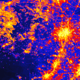
O conjunto de dados global de modificação humana (gHM, na sigla em inglês) fornece uma medida cumulativa da modificação humana de terras terrestres em todo o mundo com resolução de 1 km². Os valores de gHM variam de 0,0 a 1,0 e são calculados estimando a proporção de um determinado local (pixel) que é modificado, a intensidade estimada…
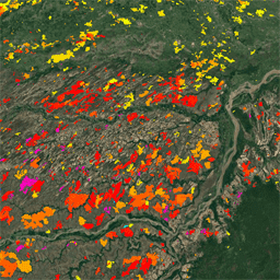
O produto de pixel de área queimada do MODIS Fire_cci, versão 5.1 (FireCCI51), é um conjunto de dados mensais globais com resolução espacial de aproximadamente 250 m que contém informações sobre a área queimada e dados auxiliares. Ele é baseado na refletância da superfície na banda do infravermelho próximo (NIR) do instrumento MODIS a bordo…
[[["Fácil de entender","easyToUnderstand","thumb-up"],["Meu problema foi resolvido","solvedMyProblem","thumb-up"],["Outro","otherUp","thumb-up"]],[["Não contém as informações de que eu preciso","missingTheInformationINeed","thumb-down"],["Muito complicado / etapas demais","tooComplicatedTooManySteps","thumb-down"],["Desatualizado","outOfDate","thumb-down"],["Problema na tradução","translationIssue","thumb-down"],["Problema com as amostras / o código","samplesCodeIssue","thumb-down"],["Outro","otherDown","thumb-down"]],[],[[["\u003cp\u003eThe Global Human Modification (gHM) dataset provides a cumulative measure of human impact on land, ranging from 0.0 to 1.0, by assessing the proportion and intensity of modification at a 1 sq km resolution.\u003c/p\u003e\n"],["\u003cp\u003eFireCCI51 offers monthly global data on burned areas at approximately 250m resolution using MODIS NIR reflectance, including supplementary information.\u003c/p\u003e\n"]]],[],null,["# Datasets tagged landscape-gradient in Earth Engine\n\n-\n\n |-----------------------------------------------------------------------------------------------------------------------------------------------------------------------------------------------------------------------------------------------------------------------------------------------------------------------------------------------------|\n | [### CSP gHM: Global Human Modification](/earth-engine/datasets/catalog/CSP_HM_GlobalHumanModification) |\n | The global Human Modification dataset (gHM) provides a cumulative measure of human modification of terrestrial lands globally at 1 square-kilometer resolution. The gHM values range from 0.0-1.0 and are calculated by estimating the proportion of a given location (pixel) that is modified, the estimated intensity ... |\n | [csp](/earth-engine/datasets/tags/csp) [fragmentation](/earth-engine/datasets/tags/fragmentation) [human-modification](/earth-engine/datasets/tags/human-modification) [landcover](/earth-engine/datasets/tags/landcover) [landscape-gradient](/earth-engine/datasets/tags/landscape-gradient) [population](/earth-engine/datasets/tags/population) |\n\n-\n\n |-------------------------------------------------------------------------------------------------------------------------------------------------------------------------------------------------------------------------------------------------------------------------------------------------------|\n | [### FireCCI51: MODIS Fire_cci Burned Area Pixel Product, Version 5.1](/earth-engine/datasets/catalog/ESA_CCI_FireCCI_5_1) |\n | The MODIS Fire_cci Burned Area pixel product version 5.1 (FireCCI51) is a monthly global \\~250m spatial resolution dataset containing information on burned area as well as ancillary data. It is based on surface reflectance in the Near Infrared (NIR) band from the MODIS instrument onboard ... |\n | [burn](/earth-engine/datasets/tags/burn) [climate-change](/earth-engine/datasets/tags/climate-change) [copernicus](/earth-engine/datasets/tags/copernicus) [esa](/earth-engine/datasets/tags/esa) [fire](/earth-engine/datasets/tags/fire) [fragmentation](/earth-engine/datasets/tags/fragmentation) |"]]