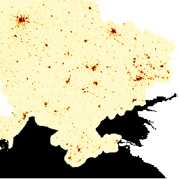
הנתונים של LandScan High Definition (HD) מספקים אומדנים של אוכלוסייה ברזולוציה של 3 שניות קשת (~100m). הערכים בכל תא של LandScan HD מייצגים אומדן של מספר האנשים בסביבה (כלומר, ממוצע של 24 שעות). כך הנתונים משקפים את כל הפעילות הפוטנציאלית של אנשים במהלך הקורס…
מערך הנתונים של LandScan, שמסופק על ידי Oak Ridge National Laboratory (ORNL), מציע מערך נתונים מקיף ברזולוציה גבוהה של התפלגות האוכלוסייה בעולם, שמשמש כמשאב חשוב למגוון רחב של אפליקציות. LandScan משתמש בטכניקות מתקדמות של מידול מרחבי ובמקורות מתקדמים של נתונים גיאו-מרחביים, ומספק מידע מפורט על…
[[["התוכן קל להבנה","easyToUnderstand","thumb-up"],["התוכן עזר לי לפתור בעיה","solvedMyProblem","thumb-up"],["סיבה אחרת","otherUp","thumb-up"]],[["חסרים לי מידע או פרטים","missingTheInformationINeed","thumb-down"],["התוכן מורכב מדי או עם יותר מדי שלבים","tooComplicatedTooManySteps","thumb-down"],["התוכן לא עדכני","outOfDate","thumb-down"],["בעיה בתרגום","translationIssue","thumb-down"],["בעיה בדוגמאות/בקוד","samplesCodeIssue","thumb-down"],["סיבה אחרת","otherDown","thumb-down"]],[],[],["LandScan HD provides population estimates for Ukraine at a 3 arc-second (~100m) resolution, representing a 24-hour average population count per cell. LandScan Global, from Oak Ridge National Laboratory, offers a high-resolution global population distribution dataset. It utilizes spatial modeling and geospatial data to provide detailed population information for diverse applications. Both datasets are tagged with \"landscan\" and \"population,\" indicating their focus on population distribution analysis.\n"]]