Page Summary
-
The 2000 Greenland Mosaic dataset provides a complete 15m resolution image mosaic of the Greenland ice sheet from 1999-2002, derived from Landsat 7 and RADARSAT-1 imagery.
-
The ASTER L1T Radiance dataset comes from a multispectral imager but currently has a data collection gap between November 2024 and January 2025.
-
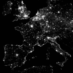
The CCNL dataset is a reprocessed version of DMSP-OLS data, improved to mitigate inconsistencies and saturation effects in nighttime light imagery from 1992-2013.
-
The DMSP OLS: Global Radiance-Calibrated Nighttime Lights dataset offers global nighttime lights images without sensor saturation, detecting visible and near-infrared emission sources.
-
The DMSP OLS: Nighttime Lights Time Series dataset provides cloud-free composites of global nighttime lights using archived DMSP-OLS data.
-
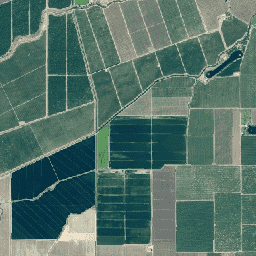
The NAIP dataset consists of aerial imagery acquired during agricultural growing seasons in the continental U.S. on a cyclical basis.
-
2000 Greenland Mosaic - Greenland Ice Mapping Project (GIMP)
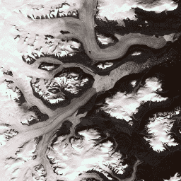
This dataset provides a complete 15 m resolution image mosaic of the Greenland ice sheet derived from Landsat 7 ETM+ and RADARSAT-1 SAR imagery from the years 1999 to 2002. The methods include a combination of image cloud masking, pan sharpening, image sampling and resizing, … arctic gimp greenland imagery nasa polar -
ASTER L1T Radiance
Note: There is a gap in data collection between November 28, 2024 and January 16, 2025 due to technical issues with the ASTER instrument. See the USGS announcement for more information. The Advanced Spaceborne Thermal Emission and Reflection Radiometer (ASTER) is a multispectral imager that … aster imagery nasa nir radiance satellite-imagery -
Brazil Forest Imagery Dataset 2008: Analytic Basemap
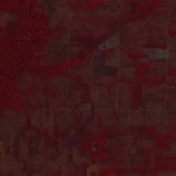
This dataset provides up to a 10-meter resolution multispectral (green, red, and near-infrared) basemap of Brazil, primarily captured in 2008, to support implementation of the Brazil Forest Code. The mosaic is synthesized from SPOT 2, 4, and 5 satellite data. It serves as a higher-resolution … brazil forest-code google imagery multispectral satellite-imagery -
CCNL: Consistent and Corrected Nighttime Light Dataset from DMSP-OLS (1992-2013) v1
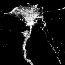
The Consistent and Corrected Nighttime Lights (CCNL) dataset is a reprocessed version of the Defense Meteorological Program (DMSP) Operational Line-Scan System (OLS) Version 4. A series of methods was used to mitigate the impact of inter-annual inconsistency, saturation, and blooming effects and to improve data … dmsp eog imagery lights nighttime ols -
DMSP OLS: Global Radiance-Calibrated Nighttime Lights Version 4, Defense Meteorological Program Operational Linescan System
The Defense Meteorological Program (DMSP) Operational Line-Scan System (OLS) has a unique capability to detect visible and near-infrared (VNIR) emission sources at night. This collection contains global nighttime lights images with no sensor saturation. The sensor is typically operated at a high-gain setting to enable … dmsp eog imagery lights nighttime ols -
DMSP OLS: Nighttime Lights Time Series Version 4, Defense Meteorological Program Operational Linescan System

The Defense Meteorological Program (DMSP) Operational Line-Scan System (OLS) has a unique capability to detect visible and near-infrared (VNIR) emission sources at night. Version 4 of the DMSP-OLS Nighttime Lights Time Series consists of cloud-free composites made using all the available archived DMSP-OLS smooth resolution … dmsp eog imagery lights nighttime ols -
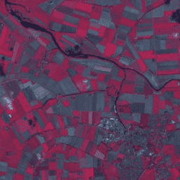
NAIP: National Agriculture Imagery Program
The National Agriculture Imagery Program (NAIP) acquires aerial imagery during the agricultural growing seasons in the continental U.S. NAIP projects are contracted each year based upon available funding and the imagery acquisition cycle. Beginning in 2003, NAIP was acquired on a 5-year cycle. 2008 was … agriculture highres imagery orthophotos usda -
SPOT Panchromatic Imagery 5-10m, Brazil
This collection contains the raw panchromatic (PAN) bands from the SPOT 2, 4, and 5 satellites for Brazil circa 2008. The panchromatic sensor provides the highest native spatial resolution of the missions, capturing light across a broad visible spectrum (0.51-0.73 µm for SPOT 2, 0.61-0.68 … brazil forest-code google imagery satellite-imagery spot