-
NAIP: National Agriculture Imagery Program
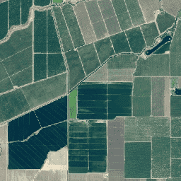
โปรแกรมภาพถ่ายทางอากาศแห่งชาติเพื่อการเกษตร (National Agriculture Imagery Program หรือ NAIP) จะจัดหาภาพถ่ายทางอากาศในช่วงฤดูเพาะปลูกในสหรัฐอเมริกาภาคพื้นทวีป โดยจะมีการทำสัญญาโครงการ NAIP ในแต่ละปีตามงบประมาณที่มีและวงจรการจัดหาภาพ ตั้งแต่ปี 2003 เป็นต้นมา NAIP ได้รับการจัดซื้อตามรอบ 5 ปี ปี 2008 เป็นปีที่ … agriculture highres imagery orthophotos usda -
แบบจำลองความสูงของเรือนยอด NEON (CHM)

ความสูงของยอดเรือนยอดเหนือพื้นดิน (แบบจำลองความสูงของเรือนยอด หรือ CHM) CHM ได้มาจากกลุ่มจุด LiDAR ของ NEON และสร้างขึ้นโดยการสร้างพื้นผิวต่อเนื่องของค่าประมาณความสูงของเรือนยอดทั่วทั้งโดเมนเชิงพื้นที่ของการสำรวจ LiDAR The … airborne canopy forest forest-biomass highres lidar -
ปริมาณไนโตรเจนในเรือนยอดของ NEON (CNC)
ความเข้มข้นของไนโตรเจนในเรือนยอดที่จำลองขึ้นโดยปรับเทียบกับการสังเกตทางเคมีของใบไม้ในพืชของ NEON และคาดการณ์ด้วยการสะท้อนแบบทิศทางของพื้นผิว L1 ซึ่งได้มาจากสเปกโทรมิเตอร์แบบถ่ายภาพ (NIS) ของ NEON แถบประกอบด้วย 1) เปอร์เซ็นต์ไนโตรเจนของเรือนยอด 2) ความไม่แน่นอนของโมเดลไนโตรเจนของเรือนยอด 3) ผลการจัดประเภทสำหรับโมเดลเข็มเทียบกับโมเดลที่ไม่ใช่เข็ม และอื่นๆ airborne canopy forest highres hyperspectral neon -
แบบจำลองระดับความสูงเชิงเลข (DEM) ของ NEON

แบบจำลองดิจิทัลของพื้นผิว (DSM) และภูมิประเทศ (DTM) ที่ได้มาจากข้อมูล LiDAR ของ NEON DSM: ลักษณะพื้นผิว (ข้อมูลภูมิประเทศที่มีพืชพรรณและโครงสร้างที่มนุษย์สร้างขึ้น) DTM: ระดับความสูงของพื้นดินเปล่า (ข้อมูลภูมิประเทศที่นำพืชพรรณและโครงสร้างที่มนุษย์สร้างขึ้นออกแล้ว) รูปภาพแสดงเป็นเมตรเหนือระดับน้ำทะเลโดยเฉลี่ย … airborne dem elevation-topography forest highres lidar -
ภาพจากกล้อง RGB ของ NEON

ภาพจากกล้องความละเอียดสูงแบบ Red-Green-Blue (RGB) ที่ผ่านการปรับแก้ภาพให้ตั้งฉากแล้วนำมาต่อกันเป็นภาพโมเสกและส่งออกไปยังตารางเชิงพื้นที่แบบคงที่และสม่ำเสมอโดยใช้การสุ่มตัวอย่างใหม่แบบเพื่อนบ้านที่ใกล้ที่สุด ความละเอียดเชิงพื้นที่คือ 0.1 ม. กล้องดิจิทัลเป็นส่วนหนึ่งของชุดเครื่องมือบนแพลตฟอร์มการสังเกตการณ์ทางอากาศ (AOP) ของ NEON ซึ่งรวมถึง … airborne forest highres neon neon-prod-earthengine orthophoto -
การสะท้อนแบบ 2 ทิศทางของพื้นผิว NEON

การสะท้อนแบบสองทิศทางของพื้นผิว AOP ของ NEON เป็นผลิตภัณฑ์ข้อมูลไฮเปอร์สเปกตรัล VSWIR (อินฟราเรดที่มองเห็นได้ถึงคลื่นสั้น) ซึ่งมี 426 แถบที่ครอบคลุมความยาวคลื่นตั้งแต่ ~380 นาโนเมตรถึง 2510 นาโนเมตร การสะท้อนแสงจะปรับขนาดตามปัจจัย 10000 ความยาวคลื่นระหว่าง 1340-1445 นาโนเมตร และ 1790-1955 นาโนเมตร จะตั้งค่าเป็น … airborne forest highres hyperspectral neon neon-prod-earthengine -
ภาพออร์โธสีจริงสาธารณะของดาวเทียม SkySat

ข้อมูลนี้จากดาวเทียม SkySat ของ Planet Labs Inc. รวบรวมขึ้นสำหรับโปรแกรมทดลอง "Skybox for Good Beta" ในปี 2015 รวมถึงสำหรับเหตุการณ์การรับมือภาวะวิกฤตต่างๆ และโปรเจ็กต์อื่นๆ อีก 2-3 โปรเจ็กต์ ข้อมูลนี้พร้อมใช้งานทั้งในคอลเล็กชันมัลติสเปกตรัม/แพน 5 แบนด์ และ … highres multispectral pansharpened planet satellite-imagery skysat -
ภาพออร์โธ RGB สาธารณะของ Planet SkySat

ข้อมูลนี้จากดาวเทียม SkySat ของ Planet Labs Inc. รวบรวมขึ้นสำหรับโปรแกรมทดลอง "Skybox for Good Beta" ในปี 2015 รวมถึงสำหรับเหตุการณ์การรับมือภาวะวิกฤตต่างๆ และโปรเจ็กต์อื่นๆ อีก 2-3 โปรเจ็กต์ ข้อมูลนี้พร้อมใช้งานทั้งในคอลเล็กชันมัลติสเปกตรัม/แพน 5 แบนด์ และ … highres pansharpened planet rgb satellite-imagery skysat