Page Summary
-
CHIRPS Daily and Pentad are 30+ year quasi-global rainfall datasets with 0.05° resolution satellite imagery and in-situ station data for trend analysis and drought monitoring.
-
CHIRTS-daily is a quasi-global, high-resolution gridded dataset (0.05° resolution) providing daily minimum and maximum 2-meter temperatures and four derived variables.
-
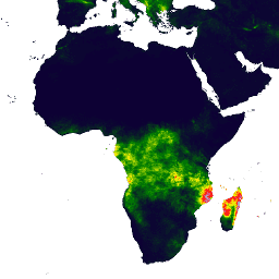
CHIRPS Precipitation Daily: Climate Hazards Center InfraRed Precipitation With Station Data (Version 2.0 Final)

Climate Hazards Center InfraRed Precipitation with Station data (CHIRPS) is a 30+ year quasi-global rainfall dataset. CHIRPS incorporates 0.05° resolution satellite imagery with in-situ station data to create gridded rainfall time series for trend analysis and seasonal drought monitoring. chg climate geophysical precipitation ucsb weather -
CHIRPS Precipitation Pentad: Climate Hazards Center InfraRed Precipitation With Station Data (Version 2.0 Final)
Climate Hazards Center InfraRed Precipitation with Station data (CHIRPS) is a 30+ year quasi-global rainfall dataset. CHIRPS incorporates 0.05° resolution satellite imagery with in-situ station data to create gridded rainfall time series for trend analysis and seasonal drought monitoring. chg climate geophysical precipitation ucsb weather -
CHIRPS Precipitation Pentad: Climate Hazards Center InfraRed Precipitation With Station Data (Version 3.0)
The Climate Hazards Center Infrared Precipitation with Stations (CHIRPS v3) is a 40+ year, high-resolution quasi-global rainfall dataset. It spans 60°N to 60°S and covers all longitudes, providing data from 1981 to near-present. CHIRPS v3 combines satellite-based thermal infrared rainfall estimates with in-situ station observations … chc chg climate geophysical precipitation ucsb -
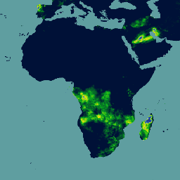
CHIRTS Temperature Daily: Climate Hazards Center InfraRed Temperature with Stations daily data product

The Climate Hazards Center InfraRed Temperature with Stations daily temperature data product (CHIRTS-daily; Verdin et al. 2020) is a quasi global, high-resolution gridded dataset (0.05° × 0.05° resolution, 60°S - 70°N) that provides daily minimum (Tmin) and maximum 2-meter temperatures (Tmax) and four derived variables: saturation vapor … chg climate daily era5 geophysical reanalysis