Page Summary
-
Several datasets offer insights into actual and reference evapotranspiration and interception rates.
-
Crop inventory and land cover data are available for Canada, the European Union, China, and the United States, including specific maps for terraces, oil palm, and irrigated lands.
-
Probability models estimate the likelihood of areas being occupied by specific agricultural commodities such as cocoa, coffee, palm, and rubber trees.
-
Datasets exist for analyzing drained organic soils and their greenhouse gas emissions related to agricultural activities.
-
Information on forest-proximate and tree-proximate populations, as well as global drivers of forest loss, is provided.
-
Actual Evapotranspiration for Australia (CMRSET Landsat V2.2)

This dataset provides accurate actual evapotranspiration (AET or ETa) for Australia using the CMRSET algorithm. The AET band (named 'ETa') contains the average daily value from the CMRSET model for all cloud-free Landsat observations in that month (indicated with value 3 in the AET Data … agriculture australia csiro evaporation evapotranspiration landsat-derived -
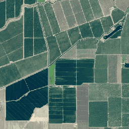
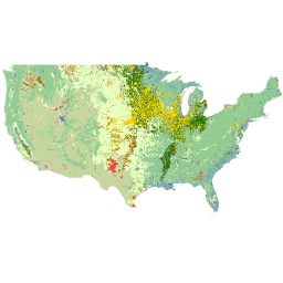
Canada AAFC Annual Crop Inventory
Starting in 2009, the Earth Observation Team of the Science and Technology Branch (STB) at Agriculture and Agri-Food Canada (AAFC) began the process of generating annual crop type digital maps. Focusing on the Prairie Provinces in 2009 and 2010, a Decision Tree (DT) based methodology … agriculture canada crop landcover -
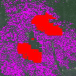
Cocoa Probability model 2025a

This image collection provides estimated per-pixel probability that the underlying area is occupied by the commodity. The probability estimates are provided at 10 meter resolution, and have been generated by a machine learning model. For details, see the technical documentation on the Forest Data Partnership … agriculture biodiversity cocoa conservation crop eudr -
Cocoa Probability model 2025b
This image collection provides estimated per-pixel probability that the underlying area is occupied by the commodity. The probability estimates are provided at 10 meter resolution, and have been generated by a machine learning model. For details, see the technical documentation on the Forest Data Partnership … agriculture alphaearth-derived biodiversity cocoa conservation crop -
Coffee Probability model 2025a

This image collection provides estimated per-pixel probability that the underlying area is occupied by the commodity. The probability estimates are provided at 10 meter resolution, and have been generated by a machine learning model. For details, see the technical documentation on the Forest Data Partnership … agriculture biodiversity coffee conservation crop eudr -
Coffee Probability model 2025b
This image collection provides estimated per-pixel probability that the underlying area is occupied by the commodity. The probability estimates are provided at 10 meter resolution, and have been generated by a machine learning model. For details, see the technical documentation on the Forest Data Partnership … agriculture alphaearth-derived biodiversity coffee conservation crop -
DESS China Terrace Map v1
This dataset is a China terrace map at 30 m resolution in 2018. It was developed through supervised pixel-based classification using multisource and multi-temporal data based on the Google Earth Engine platform. The overall accuracy and kappa coefficient achieved 94% and 0.72, respectively. This first … agriculture landcover landuse landuse-landcover tsinghua -
Drained Organic Soils Emissions (Annual) 1.0
The two related FAO datasets on Drained Organic Soils provide estimates of: DROSA-A: area of Organic Soils (in hectares) drained for agricultural activities (cropland and grazed grassland) DROSE-A: carbon (C) and nitrous oxide (N2O) estimates (in gigagrams) from the agricultural drainage of organic soils under … agriculture climate climate-change emissions fao ghg -
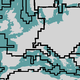
ESA WorldCereal 10 m v100

The European Space Agency (ESA) WorldCereal 10 m 2021 product suite consists of global-scale annual and seasonal crop maps and their related confidence. They were generated as part of the ESA-WorldCereal project. More information on the content of these products and the methodology used to … agriculture copernicus crop esa global landcover -
ESA WorldCereal AEZ v100
The European Space Agency (ESA) WorldCereal classification system aims for product generation within one month after the end of a particular growing season. Due to the dynamic nature of these growing seasons across the globe, a global stratification into Agro-Ecological Zones (AEZ) was performed based … agriculture boundaries crop esa global table -
ESA WorldCereal Active Cropland 10 m v100
The European Space Agency (ESA) WorldCereal Active Cropland 10 m 2021 product suite contains global-scale seasonal active cropland markers. They were generated as part of the ESA-WorldCereal project. The active cropland products indicate whether or not a pixel identified as temporary crops has been actively … agriculture copernicus crop esa global landcover -
EUCROPMAP
European crop type maps based on Sentinel-1 and LUCAS Copernicus 2018 in-situ observations for 2018, and a combination of Sentinel-1, Sentinel-2, and auxiliary data with LUCAS Copernicus 2022 observations for 2022. Based on the unique LUCAS 2018 Copernicus in-situ survey, this dataset represents the first … agriculture crop eu jrc lucas sentinel1-derived -
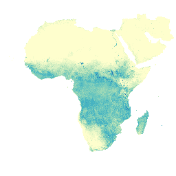
Forest proximate people (FPP) 1.0
The "Forest Proximate People" (FPP) dataset is one of the data layers contributing to the development of indicator #13, "number of forest-dependent people in extreme poverty," of the Collaborative Partnership on Forests (CPF) Global Core Set of forest-related indicators (GCS). The FPP dataset provides an … agriculture fao forest global plant-productivity population -
GFSAD1000: Cropland Extent 1km Multi-Study Crop Mask, Global Food-Support Analysis Data
The GFSAD is a NASA-funded project to provide high-resolution global cropland data and their water use that contributes towards global food security in the twenty-first century. The GFSAD products are derived through multi-sensor remote sensing data (e.g., Landsat, MODIS, AVHRR), secondary data, and field-plot data … agriculture crop landcover usgs -
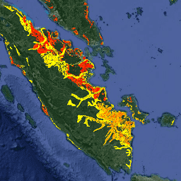
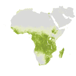
Global Map of Oil Palm Plantations
The dataset is a 10m global industrial and smallholder oil palm map for 2019. It covers areas where oil palm plantations were detected. The classified images are the output of a convolutional neural network based on Sentinel-1 and Sentinel-2 half-year composites. See article for additional … agriculture biodiversity conservation crop global landuse -
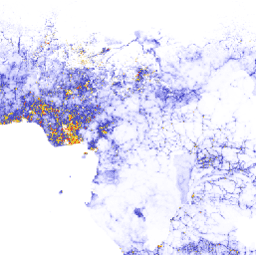
IrrMapper Irrigated Lands, Version 1.2
IrrMapper is an annual classification of irrigation status in the 11 Western United States made at Landsat scale (i.e., 30 m) using the Random Forest algorithm, covering years 1986 - present. While the IrrMapper paper describes classification of four classes (i.e., irrigated, dryland, uncultivated, wetland), … agriculture landsat-derived -
NAIP: National Agriculture Imagery Program
The National Agriculture Imagery Program (NAIP) acquires aerial imagery during the agricultural growing seasons in the continental U.S. NAIP projects are contracted each year based upon available funding and the imagery acquisition cycle. Beginning in 2003, NAIP was acquired on a 5-year cycle. 2008 was … agriculture highres imagery orthophotos usda -
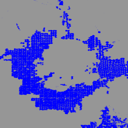
Palm Probability model 2025a

This image collection provides estimated per-pixel probability that the underlying area is occupied by the commodity. The probability estimates are provided at 10 meter resolution, and have been generated by a machine learning model. For details, see the technical documentation on the Forest Data Partnership … agriculture biodiversity conservation crop eudr forestdatapartnership -
Palm Probability model 2025b
This image collection provides estimated per-pixel probability that the underlying area is occupied by the commodity. The probability estimates are provided at 10 meter resolution, and have been generated by a machine learning model. For details, see the technical documentation on the Forest Data Partnership … agriculture alphaearth-derived biodiversity conservation crop eudr -
Rubber Probability model 2025b
This image collection provides estimated per-pixel probability that the underlying area is occupied by the commodity. The probability estimates are provided at 10 meter resolution, and have been generated by a machine learning model. For details, see the technical documentation on the Forest Data Partnership … agriculture alphaearth-derived biodiversity conservation crop eudr -
Rubber Tree Probability model 2025a

This image collection provides estimated per-pixel probability that the underlying area is occupied by the commodity. The probability estimates are provided at 10 meter resolution, and have been generated by a machine learning model. For details, see the technical documentation on the Forest Data Partnership … agriculture biodiversity conservation crop eudr forestdatapartnership -
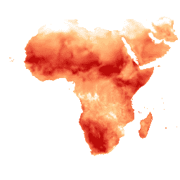
Tree proximate people (TPP) 1.0
The "Tree Proximate People" (TPP) is one of the datasets contributing to the development of indicator #13, number of forest-dependent people in extreme poverty, of the Collaborative Partnership on Forests (CPF) Global Core Set of forest-related indicators (GCS). The TPP dataset provides 4 different estimates … agriculture fao forest global plant-productivity population -
UN FAO Drained Organic Soils Area (Annual) 1.0

The two related FAO datasets on Drained Organic Soils provide estimates of: DROSA-A: area of Organic Soils (in hectares) drained for agricultural activities (cropland and grazed grassland) DROSE-A: carbon (C) and nitrous oxide (N2O) estimates (in gigagrams) from the agricultural drainage of organic soils under … agriculture climate climate-change emissions fao ghg -
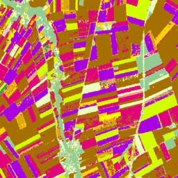
USDA NASS Cropland Data Layers
The Cropland Data Layer (CDL) is a crop-specific land cover data layer created annually for the continental United States using moderate resolution satellite imagery and extensive agricultural ground truth. The CDL is created by the USDA, National Agricultural Statistics Service (NASS), Research and Development Division, … agriculture crop landcover usda -
WAPOR Actual Evapotranspiration and Interception 2.0
The actual evapotranspiration and interception (ETIa) (dekadal, in mm/day) is the sum of the soil evaporation (E), canopy transpiration (T), and evaporation from rainfall intercepted by leaves (I). The value of each pixel represents the average daily ETIa in a given dekad. agriculture fao wapor water water-vapor -
WAPOR Actual Evapotranspiration and Interception 3.0

The actual evapotranspiration and interception (ETIa) (dekadal, in mm/day) is the sum of the soil evaporation (E), canopy transpiration (T), and evaporation from rainfall intercepted by leaves (I). The value of each pixel represents the average daily ETIa in a given dekad. agriculture fao wapor water water-vapor -
WAPOR Daily Reference Evapotranspiration 2.0
Reference evapotranspiration (RET) is defined as the evapotranspiration from a hypothetical reference crop and it simulates the behaviour of a well-watered grass surface. Each pixel represents the daily reference evapotranspiration in mm. agriculture fao wapor water water-vapor -
WAPOR Daily Reference Evapotranspiration 3.0

Reference evapotranspiration (RET) is defined as the evapotranspiration from a hypothetical reference crop and it simulates the behaviour of a well-watered grass surface. Each pixel represents the daily reference evapotranspiration in mm. agriculture fao wapor water water-vapor -
WAPOR Dekadal Evaporation 2.0
The evaporation (E) data component (dekadal, in mm/day) is the actual evaporation of the soil surface. The value of each pixel represents the average daily actual evaporation for that specific dekad. agriculture fao wapor water water-vapor -
WAPOR Dekadal Evaporation 3.0

The evaporation (E) data component (dekadal, in mm/day) is the actual evaporation of the soil surface. The value of each pixel represents the average daily actual evaporation for that specific dekad. agriculture fao wapor water water-vapor -
WAPOR Dekadal Interception 2.0
The interception (I) data component (dekadal, in mm/day) represents the evaporation of intercepted rainfall from the vegetation canopy. Interception is the process where rainfall is captured by the leaves. Part of this captured rainfall will evaporate again. The value of each pixel represents the average … agriculture fao wapor water water-vapor -
WAPOR Dekadal Interception 3.0

The interception (I) data component (dekadal, in mm/day) represents the evaporation of intercepted rainfall from the vegetation canopy. Interception is the process where rainfall is captured by the leaves. Part of this captured rainfall will evaporate again. The value of each pixel represents the average … agriculture fao wapor water water-vapor -
WAPOR Dekadal Net Primary Production 2.0
Net primary production (NPP) is a fundamental characteristic of an ecosystem, expressing the conversion of carbon dioxide into biomass driven by photosynthesis. The pixel value represents the mean daily NPP for that specific dekad. agriculture fao plant-productivity wapor water -
WAPOR Dekadal Reference Evapotranspiration 2.0
Reference evapotranspiration (RET) is defined as the evapotranspiration from a hypothetical reference crop and it simulates the behaviour of a well-watered grass surface. The value of each pixel represents the average of the daily reference evapotranspiration for that specific dekad. agriculture fao wapor water water-vapor -
WAPOR Dekadal Reference Evapotranspiration 3.0

Reference evapotranspiration (RET) is defined as the evapotranspiration from a hypothetical reference crop and it simulates the behaviour of a well-watered grass surface. The value of each pixel represents the average of the daily reference evapotranspiration for that specific dekad. agriculture fao wapor water water-vapor -
WAPOR Dekadal Transpiration 2.0
The transpiration (T) data component (dekadal, in mm/day) is the actual transpiration of the vegetation canopy. The value of each pixel represents the average daily actual transpiration for that specific dekad. agriculture fao wapor water water-vapor -
WAPOR Dekadal Transpiration 3.0

The transpiration (T) data component (dekadal, in mm/day) is the actual transpiration of the vegetation canopy. The value of each pixel represents the average daily actual transpiration for that specific dekad. agriculture fao global wapor water water-vapor -
WRI/Google DeepMind Global Drivers of Forest Loss 2001-2022 v1.0

This dataset maps the dominant driver of tree cover loss from 2001-2022 globally at 1 km resolution. Produced by the World Resources Institute (WRI) and Google DeepMind, the data were developed using a global neural network model (ResNet) trained on a set of samples collected … agriculture deforestation forest forest-biomass google landandcarbon -
WRI/Google DeepMind Global Drivers of Forest Loss 2001-2023 v1.1

This dataset maps the dominant driver of tree cover loss from 2001-2023 globally at 1 km resolution. Produced by the World Resources Institute (WRI) and Google DeepMind, the data were developed using a global neural network model (ResNet) trained on a set of samples collected … agriculture deforestation forest forest-biomass google landandcarbon -
WRI/Google DeepMind Global Drivers of Forest Loss 2001-2024 v1.2

This dataset maps the dominant driver of tree cover loss from 2001-2024 globally at 1 km resolution. Produced by the World Resources Institute (WRI) and Google DeepMind, the data were developed using a global neural network model (ResNet) trained on a set of samples collected … agriculture deforestation forest forest-biomass google landandcarbon -
WRI/Google DeepMind Global Drivers of Forest Loss 2001-2025 v1.3
This dataset maps the dominant driver of tree cover loss from 2001-2025 globally at 1 km resolution. Produced by the World Resources Institute (WRI) and Google DeepMind, the data were developed using a global neural network model (ResNet) trained on a set of samples collected … agriculture deforestation forest forest-biomass google landandcarbon