Geoscience Australia 為決策者提供地球觀測服務、專家建議和資訊。計畫目標如下:
- 確保持續取得遙測資訊,以支援政府優先事項。
- 在政府、產業和更廣大的社群中,推廣衛星影像的使用方式和價值。
- 透過充分發揮地球觀測衛星的潛力,進而提升遙測科學
- 提供資料管理服務,確保資料存取權。
- 協調全國的圖像資料,以便在災難和緊急情況中提供支援。
-
國家間潮間數位地形模型 25 公尺 1.0.0 版 [已淘汰]
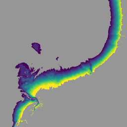
國家間歇帶數位高程模型 (NIDEM;Bishop-Taylor 等人,2018、2019 年) 是澳洲露出間歇帶的大陸規模高程資料集。NIDEM 提供澳洲潮間帶沙灘和海岸、潮間帶和岩岸,以及 25 公尺深的珊瑚礁,這是首次以三維方式呈現這些地形。 australia dem ga geoscience-aus-cat landsat-derived publisher-dataset -
DEA 幾何中位數和中位數絕對偏差 - Landsat 5 3.1.0 [已淘汰]

這項產品提供統計工具,可利用 Digital Earth Australia 提供的 Landsat 5 時序資料,提供一般情況的年度圖像,以及特定年份的區域變化情形。產品的區域中位數部分提供「平均」無雲區的… 澳洲 ga 地理科學-澳洲-貓咪 Landsat 衍生 出版商-資料集 -
DEA 幾何中位數和中位數絕對偏差 - Landsat 7 3.1.0 [已淘汰]

這項產品提供統計工具,可利用 Digital Earth Australia 提供的 Landsat 7 時序資料,提供一般情況的年度圖像,以及特定年份的區域變化情形。產品的區域中位數部分提供「平均」無雲區的… 澳洲 ga 地理科學-澳洲-貓咪 Landsat 衍生 出版商-資料集 -
DEA 幾何中位數和中位數絕對偏差 - Landsat 8 和 9 4.0.0 版 [已淘汰]
這項產品提供統計工具,可利用 Digital Earth Australia 提供的 Landsat 8 和 9 資料時序資料,提供一般情況的年度圖像,以及特定年份的區域變化情形。自 2022 年起,Landsat 8 和 Landsat 9 的 australia ga geoscience-aus-cat landsat-derived publisher-dataset -
DEA Land Cover 1.0.0 [已淘汰]

Digital Earth Australia (DEA) Land Cover 使用糧農組織土地覆蓋類別分類系統第 2 版 (Di Gregorio and Jansen, 1998; 2005),為澳洲提供年度土地覆蓋類別分類。DEA Land Cover 將 30 多年的衛星圖像轉譯成 … australia ga geoscience-aus-cat landcover landsat-derived publisher-dataset -
DEA Water Observations Statistics 3.1.6 [deprecated]

Digital Earth Australia (DEA) Water Observations 會使用演算法,將 Landsat 衛星圖像的每個像素分類為「濕」、「乾」或「無效」。水文觀測統計資料會提供以下資訊:Landsat 衛星每年可清楚看到某個區域的次數、可清楚看到該區域的 Landsat 衛星數量,以及每個 Landsat 衛星可清楚看到該區域的次數。 澳洲 ga 地質科學-澳洲-貓 Landsat 衍生 發布者-資料集 水