Geoscience Australia は、意思決定者向けに地球観測サービス、専門家のアドバイス、情報を提供しています。プログラムの目標は次のとおりです。
- 政府の優先事項をサポートするために、リモートセンシング情報へのアクセスを継続的に確保する。
- 政府、産業、幅広いコミュニティにおける衛星画像の使用と価値を促進する。
- EOS の価値を最大限に引き出し、その価値を活用することでリモート センシング科学を進歩させる
- データへのアクセスを確保するためのデータ管理を提供します。
- 災害や緊急事態に対応する全国的な画像調整を提供します。
-
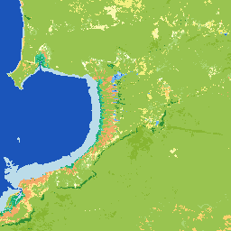
国立干潟デジタル標高モデル 25 m 1.0.0 [非推奨]
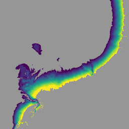
ナショナル インタータイド デジタル標高モデル(NIDEM、Bishop-Taylor 他 2018、2019)は、オーストラリアの露出している干潮帯の大陸規模の標高データセットです。NIDEM は、オーストラリアの干潮時の砂浜や海岸、干潟、岩場、サンゴ礁を 25 m の解像度で初めて立体的に表現しています。 australia dem ga geoscience-aus-cat landsat-derived publisher-dataset -
DEA 幾何平均と中央絶対偏差 - Landsat 5 3.1.0 [非推奨]
このプロダクトには、Digital Earth Australia で利用可能な Landsat 5 データの時系列を利用する統計ツールが用意されており、一般的な状況と特定の年における地域の変化を示す年次画像を提供します。プロダクトの地理的な中央値は、雲のない「平均的な」… australia ga geoscience-aus-cat landsat-derived publisher-dataset -
DEA 幾何平均と中央絶対偏差 - Landsat 7 3.1.0 [非推奨]
このプロダクトには、Digital Earth Australia で利用可能な Landsat 7 データの時系列を活用するための統計ツールが用意されており、一般的な状況と特定の年における地域の変化を示す年次画像を提供します。プロダクトの地理的な中央値は、雲のない「平均的な」… australia ga geoscience-aus-cat landsat-derived publisher-dataset -
DEA 幾何学的中央値と中央絶対偏差 - Landsat 8 および 9 v4.0.0 [非推奨]
このプロダクトには、Digital Earth Australia で利用可能な Landsat 8 と Landsat 9 のタイムシリーズ データを利用するための統計ツールが用意されており、一般的な状況と特定の年における地域の変化を示す年間画像を提供します。2022 年以降は、Landsat 8 と … australia ga geoscience-aus-cat landsat-derived publisher-dataset -
DEA 土地被覆 1.0.0 [非推奨]
Digital Earth Australia(DEA)Land Cover は、Food and Agriculture Organisation Land Cover Classification System 分類バージョン 2(Di Gregorio and Jansen, 1998; 2005)を使用して、オーストラリアの土地被覆を年ごとに分類しています。DEA 土地被覆は、30 年以上にわたる衛星画像を以下のような証拠に変換します。 australia ga geoscience-aus-cat landcover landsat-derived publisher-dataset -
DEA 水質観測統計 3.1.6 [非推奨]

Digital Earth Australia(DEA)の水域観測では、アルゴリズムを使用して、Landsat 衛星画像の各ピクセルを「湿地」、「乾地」、「無効」に分類します。水域観測統計情報には、Landsat 衛星が対象地域を鮮明に撮影できた回数、撮影できた回数のうち、雲が … australia ga geoscience-aus-cat landsat-derived publisher-dataset water