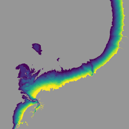
National Intertidal Digital Elevation Model(NIDEM; Bishop-Taylor 他 2018、2019)は、オーストラリアの干潟の標高を大陸規模で示すデータセットです。NIDEM は、オーストラリアの潮間帯の砂浜と海岸、干潟、岩礁とサンゴ礁を 25 m の解像度で 3 次元で表現した最初のデータセットです。
[[["わかりやすい","easyToUnderstand","thumb-up"],["問題の解決に役立った","solvedMyProblem","thumb-up"],["その他","otherUp","thumb-up"]],[["必要な情報がない","missingTheInformationINeed","thumb-down"],["複雑すぎる / 手順が多すぎる","tooComplicatedTooManySteps","thumb-down"],["最新ではない","outOfDate","thumb-down"],["翻訳に関する問題","translationIssue","thumb-down"],["サンプル / コードに問題がある","samplesCodeIssue","thumb-down"],["その他","otherDown","thumb-down"]],[],[],["The datasets provide various models and data for Australia. These include Digital Elevation Models (DEMs) at 5m resolution from LiDAR surveys and hydrologically enforced/smoothed DEMs derived from SRTM data. The National Intertidal DEM represents Australia's intertidal zone at 25m. Also featured are Landsat-derived products like annual land cover classifications, water observation statistics, and geometric median/median absolute deviation datasets. These Landsat products utilize Landsat 5, 7, 8, and 9 data to provide insights into annual conditions and changes.\n"]]