- 目录所有者
- MapBiomas
- 数据集可用时间
- 1985-01-01T00:00:00Z–2024-12-31T00:00:00Z
- 数据集生产者
- MapBiomas
- 联系人
- contato@mapbiomas.org
- 标签
说明
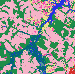
巴西 MapBiomas 土地利用和土地覆盖 (LULC) 数据集由 MapBiomas 项目每年使用 Landsat 卫星图像和机器学习分类技术生成。该数据集以 30 米的分辨率提供一致的、主题详细的地图,涵盖数十年,并且每年更新一次。
该集合中的每个图像都包含年度土地覆盖分类,像素值表示分类土地覆盖类别,例如森林、农业、牧场、水体和城市区域。 分类图例在所有年份中都是标准化和维护的,从而可以对土地利用变化、森林砍伐、植树造林和其他景观动态进行多时态分析。
该分类基于 Landsat 5 (TM)、Landsat 7 (ETM+)、Landsat 8 和 9 (OLI/TIRS) 地表反射率数据,这些数据经过预处理和镶嵌,可为每年生成无云合成图像。 分类过程包括使用参考样本训练的自动决策树,以及区域专家进行的人工验证。
每个图像都包含一个名为“classification”的频段,表示该特定年份、版本和集合 ID 的土地覆盖分类。
如需了解详情、分类图例、方法和准确性评估,请访问 MapBiomas 网站。
建议您查阅分类图例来解读类别值。 请注意,MapBiomas 提供的是离散分类地图,而不是概率。 这些地图最适合地图转换、时序分析和土地政策监控应用。
频段
频段
像素大小:30 米(所有频段)
| 名称 | 像元大小 | 说明 |
|---|---|---|
classification |
30 米 | 土地利用和土地覆盖分类,整数值对应于 MapBiomas 图例类别。 |
classification 类表
| 值 | 颜色 | 说明 |
|---|---|---|
| 1 | #1f8d49 | 森林 |
| 3 | #1f8d49 | 森林形成 |
| 4 | #7dc975 | 稀树草原形成 |
| 5 | #04381d | Mangrove |
| 6 | #007785 | 可淹没的森林 |
| 9 | #7a5900 | 森林种植园 |
| 10 | #d6bc74 | 草本和灌木植被 |
| 11 | #519799 | 湿地 |
| 12 | #d6bc74 | 草地 |
| 14 | #ffefc3 | 农业 |
| 15 | #edde8e | 牧场 |
| 18 | #e974ed | 农业 |
| 19 | #c27ba0 | 临时作物 |
| 20 | #db7093 | 甘蔗 |
| 21 | #ffefc3 | 用途组合 |
| 22 | #d4271e | 无植被区域 |
| 23 | #ffa07a | 沙滩、沙丘和沙地 |
| 24 | #d4271e | 市区 |
| 25 | #db4d4f | 其他无植被区域 |
| 26 | #2532e4 | 水 |
| 29 | #ffaa5f | 岩石露头 |
| 30 | #9c0027 | 矿业 |
| 31 | #091077 | 水产业 |
| 32 | #fc8114 | 高盐度潮滩 |
| 33 | #2532e4 | 河流、湖泊和海洋 |
| 35 | #9065d0 | 棕榈油 |
| 36 | #d082de | 多年生作物 |
| 39 | #f5b3c8 | 大豆 |
| 40 | #c71585 | Rice |
| 41 | #f54ca9 | 其他临时作物 |
| 46 | #d68fe2 | 咖啡 |
| 47 | #9932cc | Citrus |
| 48 | #e6ccff | 其他多年生作物 |
| 49 | #02d659 | 林地沙洲植被 |
| 50 | #ad5100 | 草本沙洲植被 |
| 62 | #ff69b4 | 棉(Beta 版) |
| 75 | #c12100 | 光伏发电站(Beta 版) |
图像属性
图像属性
| 名称 | 类型 | 说明 |
|---|---|---|
| 年 | INT | 土地利用和土地覆盖分类的年份。 |
| 版本 | STRING | 土地利用和土地覆盖分类的版本。 |
| collection_id | 双精度 | 土地利用和土地覆盖分类的集合标识符。 |
使用条款
使用条款
引用
Souza 等人 (2020) - Reconstructing Three Decades of Land Use and Land Cover Changes in Brazilian Biomes with Landsat Archive and Earth Engine - Remote Sensing, Volume 12, Issue 17, 10.3390/rs12172735.
DOI
通过 Earth Engine 探索
代码编辑器 (JavaScript)
/**
  MapBiomas Collection 10 - LULC Visualization for 2024
*/

// Define the asset path for MapBiomas Collection 10
var assetPath = 'projects/mapbiomas-public/assets/brazil/lulc/v1';

// Define the year for visualization
var year = 2024;

// Load the classified image for the year 2024 from Collection 10
var collection = ee.ImageCollection(assetPath)
	.filter(ee.Filter.eq('collection_id', 10.0))
	.filter(ee.Filter.eq('version', 'v1'))
	.filter(ee.Filter.eq('year', year));

// Define visualization parameters
var visParams = {
	min: 0,
	max: 75,  // Maximum class value in Collection 10
	palette: [
		'ffffff',  // [0] Not Observed
		'32a65e',  // [1] --
		'32a65e',  // [2] --
		'1f8d49',  // [3] Forest Formation
		'7dc975',  // [4] Savanna Formation
		'04381d',  // [5] Mangrove
		'026975',  // [6] Floodable Forest
		'000000',  // [7] --
		'000000',  // [8] --
		'7a6c00',  // [9] Forest Plantation
		'ad975a',  // [10] --
		'519799',  // [11] Wetland
		'd6bc74',  // [12] Grassland
		'd89f5c',  // [13] Other Non Forest Formations
		'FFFFB2',  // [14] --
		'edde8e',  // [15] Pasture
		'000000',  // [16] --
		'000000',  // [17] --
		'f5b3c8',  // [18] Agriculture
		'C27BA0',  // [19] --
		'db7093',  // [20] Sugar Cane
		'ffefc3',  // [21] Mosaic of Uses
		'db4d4f',  // [22] Non vegetated area
		'ffa07a',  // [23] Beach, Dune and Sand Spot
		'd4271e',  // [24] Urban Area
		'db4d4f',  // [25] Other Non Vegetated Areas
		'0000FF',  // [26] --
		'000000',  // [27] --
		'000000',  // [28] --
		'ffaa5f',  // [29] Rocky Outcrop
		'9c0027',  // [30] Mining
		'091077',  // [31] Aquaculture
		'fc8114',  // [32] Hypersaline Tidal Flat
		'2532e4',  // [33] Rivers, Lakes and Ocean
		'93dfe6',  // [34] Glacier
		'9065d0',  // [35] --
		'd082de',  // [36] --
		'000000',  // [37] --
		'000000',  // [38] --
		'f5b3c8',  // [39] Soybean
		'c71585',  // [40] Rice
		'f54ca9',  // [41] Other Temporary Crops
		'cca0d4',  // [42] --
		'dbd26b',  // [43] --
		'807a40',  // [44] --
		'e04cfa',  // [45] --
		'd68fe2',  // [46] Coffee
		'9932cc',  // [47] Citrus
		'e6ccff',  // [48] Other Perennial Crops
		'02d659',  // [49] Wooded Sandbank Vegetation
		'ad5100',  // [50] Herbaceous Sandbank Vegetation
		'000000',  // [51] --
		'000000',  // [52] --
		'000000',  // [53] --
		'000000',  // [54] --
		'000000',  // [55] --
		'000000',  // [56] --
		'CC66FF',  // [57] --
		'FF6666',  // [58] --
		'006400',  // [59] --
		'8d9e8b',  // [60] --
		'f5d5d5',  // [61] Salt Flats
		'ff69b4',  // [62] Cotton
		'ebf8b5',  // [63] --
		'000000',  // [64] --
		'000000',  // [65] --
		'91ff36',  // [66] --
		'7dc975',  // [67] --
		'e97a7a',  // [68] --
		'0fffe3',  // [69] Coral Reefs
		'000000',  // [70] --
		'000000',  // [71] --
		'000000',  // [72] --
		'000000',  // [73] --
		'000000',  // [74] --
		'c12100',  // [75] Photovoltaic Power Plant
	]
};

// Add the layer to the map
Map.addLayer(collection, visParams, 'MapBiomas LULC 2024');

// Center the map on the image with a zoom level of 5 (covers Brazil)
Map.centerObject(collection, 5);