- カタログの所有者
- MapBiomas
- 利用可能なデータセットの期間
- 1985-01-01T00:00:00Z–2024-12-31T00:00:00Z
- データセットの作成者
- MapBiomas
- 連絡先
- contato@mapbiomas.org
- タグ
説明
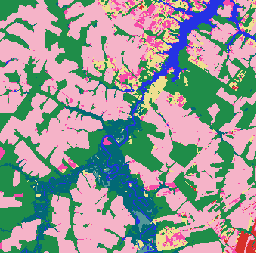
ブラジルの MapBiomas 土地利用と土地被覆(LULC)のデータセットは、MapBiomas プロジェクトが Landsat 衛星画像と機械学習分類手法を使用して毎年作成しています。このデータセットは、30 メートルの解像度で、複数の 10 年間にわたって、テーマ別に詳細なマップを継続的に提供し、毎年更新されます。
コレクション内の各画像には、森林、農業、牧草地、水域、都市部などのカテゴリ別の土地被覆クラスを表すピクセル値を含む、年間の土地被覆分類が含まれています。 分類凡例はすべての年で標準化され、維持されているため、土地利用の変化、森林破壊、森林再生、その他の景観の動態を多時相で分析できます。
分類は、Landsat 5(TM)、Landsat 7(ETM+)、Landsat 8、9(OLI/TIRS)の地表反射率データに基づいており、前処理とモザイク処理を行って、各年の雲のない合成画像が生成されます。 分類プロセスには、参照サンプルでトレーニングされた自動決定木と、地域の専門家による手動検証が含まれます。
各画像には「classification」という名前のバンドが 1 つ含まれており、特定の年、バージョン、コレクション ID の土地被覆分類を表します。
詳細、分類凡例、方法論、精度評価については、MapBiomas のウェブサイトをご覧ください。
クラス値を解釈するには、分類凡例を参照することをおすすめします。 MapBiomas は、確率ではなく、離散的な分類マップを提供します。 これらのマップは、マップの遷移、時系列分析、土地政策のモニタリング アプリケーションに最適です。
バンド
バンド
ピクセルサイズ: 30 メートル(すべてのバンド)
| 名前 | ピクセルサイズ | 説明 |
|---|---|---|
classification |
30 メートル | 土地利用と土地被覆の分類。MapBiomas の凡例クラスに対応する整数値。 |
分類クラス表
| 値 | 色 | 説明 |
|---|---|---|
| 1 | #1f8d49 | 森林 |
| 3 | #1f8d49 | 森林の形成 |
| 4 | #7dc975 | サバンナの形成 |
| 5 | #04381d | Mangrove |
| 6 | #007785 | 浸水林 |
| 9 | #7a5900 | 森林プランテーション |
| 10 | #d6bc74 | 草本植物と低木植物 |
| 11 | #519799 | 湿地帯 |
| 12 | #d6bc74 | 草原 |
| 14 | #ffefc3 | 農業 |
| 15 | #edde8e | 牧草地 |
| 18 | #e974ed | 農業 |
| 19 | #c27ba0 | 一時的な作物 |
| 20 | #db7093 | サトウキビ |
| 21 | #ffefc3 | 用途のモザイク |
| 22 | #d4271e | 植生のないエリア |
| 23 | #ffa07a | ビーチ、砂丘、砂地 |
| 24 | #d4271e | 市街地 |
| 25 | #db4d4f | その他の植生のないエリア |
| 26 | #2532e4 | 水 |
| 29 | #ffaa5f | 岩の露出 |
| 30 | #9c0027 | 鉱山 |
| 31 | #091077 | 養殖業 |
| 32 | #fc8114 | 高塩分干潟 |
| 33 | #2532e4 | 河川、湖、海 |
| 35 | #9065d0 | パーム油 |
| 36 | #d082de | 多年生作物 |
| 39 | #f5b3c8 | 大豆 |
| 40 | #c71585 | 米 |
| 41 | #f54ca9 | その他の一時的な作物 |
| 46 | #d68fe2 | コーヒー |
| 47 | #9932cc | 柑橘類 |
| 48 | #e6ccff | その他の多年生作物 |
| 49 | #02d659 | 樹木のある砂州の植生 |
| 50 | #ad5100 | 草本植物の砂州の植生 |
| 62 | #ff69b4 | コットン(ベータ版) |
| 75 | #c12100 | 太陽光発電所(ベータ版) |
画像プロパティ検出
画像プロパティ検出
| 名前 | タイプ | 説明 |
|---|---|---|
| 年 | INT | 土地利用と土地被覆の分類の年。 |
| version | STRING | 土地利用と土地被覆の分類のバージョン。 |
| collection_id | DOUBLE | 土地利用と土地被覆の分類のコレクション識別子。 |
利用規約
利用規約
引用
Souza et al.(2020 年)– Reconstructing Three Decades of Land Use and Land Cover Changes in Brazilian Biomes with Landsat Archive and Earth Engine – Remote Sensing, Volume 12, Issue 17, 10.3390/rs12172735
DOI
Earth Engine で探索する
コードエディタ(JavaScript)
/**
  MapBiomas Collection 10 - LULC Visualization for 2024
*/

// Define the asset path for MapBiomas Collection 10
var assetPath = 'projects/mapbiomas-public/assets/brazil/lulc/v1';

// Define the year for visualization
var year = 2024;

// Load the classified image for the year 2024 from Collection 10
var collection = ee.ImageCollection(assetPath)
	.filter(ee.Filter.eq('collection_id', 10.0))
	.filter(ee.Filter.eq('version', 'v1'))
	.filter(ee.Filter.eq('year', year));

// Define visualization parameters
var visParams = {
	min: 0,
	max: 75,  // Maximum class value in Collection 10
	palette: [
		'ffffff',  // [0] Not Observed
		'32a65e',  // [1] --
		'32a65e',  // [2] --
		'1f8d49',  // [3] Forest Formation
		'7dc975',  // [4] Savanna Formation
		'04381d',  // [5] Mangrove
		'026975',  // [6] Floodable Forest
		'000000',  // [7] --
		'000000',  // [8] --
		'7a6c00',  // [9] Forest Plantation
		'ad975a',  // [10] --
		'519799',  // [11] Wetland
		'd6bc74',  // [12] Grassland
		'd89f5c',  // [13] Other Non Forest Formations
		'FFFFB2',  // [14] --
		'edde8e',  // [15] Pasture
		'000000',  // [16] --
		'000000',  // [17] --
		'f5b3c8',  // [18] Agriculture
		'C27BA0',  // [19] --
		'db7093',  // [20] Sugar Cane
		'ffefc3',  // [21] Mosaic of Uses
		'db4d4f',  // [22] Non vegetated area
		'ffa07a',  // [23] Beach, Dune and Sand Spot
		'd4271e',  // [24] Urban Area
		'db4d4f',  // [25] Other Non Vegetated Areas
		'0000FF',  // [26] --
		'000000',  // [27] --
		'000000',  // [28] --
		'ffaa5f',  // [29] Rocky Outcrop
		'9c0027',  // [30] Mining
		'091077',  // [31] Aquaculture
		'fc8114',  // [32] Hypersaline Tidal Flat
		'2532e4',  // [33] Rivers, Lakes and Ocean
		'93dfe6',  // [34] Glacier
		'9065d0',  // [35] --
		'd082de',  // [36] --
		'000000',  // [37] --
		'000000',  // [38] --
		'f5b3c8',  // [39] Soybean
		'c71585',  // [40] Rice
		'f54ca9',  // [41] Other Temporary Crops
		'cca0d4',  // [42] --
		'dbd26b',  // [43] --
		'807a40',  // [44] --
		'e04cfa',  // [45] --
		'd68fe2',  // [46] Coffee
		'9932cc',  // [47] Citrus
		'e6ccff',  // [48] Other Perennial Crops
		'02d659',  // [49] Wooded Sandbank Vegetation
		'ad5100',  // [50] Herbaceous Sandbank Vegetation
		'000000',  // [51] --
		'000000',  // [52] --
		'000000',  // [53] --
		'000000',  // [54] --
		'000000',  // [55] --
		'000000',  // [56] --
		'CC66FF',  // [57] --
		'FF6666',  // [58] --
		'006400',  // [59] --
		'8d9e8b',  // [60] --
		'f5d5d5',  // [61] Salt Flats
		'ff69b4',  // [62] Cotton
		'ebf8b5',  // [63] --
		'000000',  // [64] --
		'000000',  // [65] --
		'91ff36',  // [66] --
		'7dc975',  // [67] --
		'e97a7a',  // [68] --
		'0fffe3',  // [69] Coral Reefs
		'000000',  // [70] --
		'000000',  // [71] --
		'000000',  // [72] --
		'000000',  // [73] --
		'000000',  // [74] --
		'c12100',  // [75] Photovoltaic Power Plant
	]
};

// Add the layer to the map
Map.addLayer(collection, visParams, 'MapBiomas LULC 2024');

// Center the map on the image with a zoom level of 5 (covers Brazil)
Map.centerObject(collection, 5);