- Catalog Owner
- MapBiomas
- Dataset Availability
- 1985-01-01T00:00:00Z–2024-12-31T00:00:00Z
- Dataset Producer
- MapBiomas
- Contact
- contato@mapbiomas.org
- Tags
Description
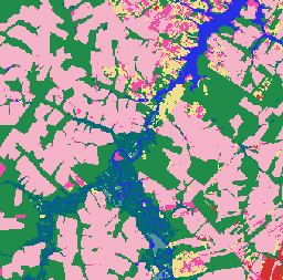
MapBiomas Land Use and Land Cover (LULC) dataset for Brazil is produced annually by the MapBiomas Project using Landsat satellite imagery and machine learning classification techniques. The dataset provides consistent, thematically detailed maps at 30-meter resolution, covering multiple decades and updated each year.
Each image in the collection contains annual land cover classifications with pixel values representing categorical land cover classes, such as forest, agriculture, pasture, water bodies, and urban areas. The classification legend is standardized and maintained across all years, enabling multi-temporal analyses of land use change, deforestation, reforestation, and other landscape dynamics.
The classification is based on Landsat 5 (TM), Landsat 7 (ETM+), Landsat 8 and 9 (OLI/TIRS) surface reflectance data, preprocessed and mosaicked to generate cloud-free composites for each year. The classification process includes automated decision trees trained with reference samples, along with manual validation by regional experts.
Each image contains one band named "classification", representing the land cover classification for that specific year, version and collection id.
For more information, classification legend, methodology, and accuracy assessments, visit the MapBiomas website.
It is recommended to consult the classification legend to interpret the class values. Note that MapBiomas provides discrete classification maps, not probabilities. These maps are most appropriate for map transitions, time series analysis, and land policy monitoring applications.
Bands
Bands
Pixel size: 30 meters (all bands)
| Name | Pixel Size | Description |
|---|---|---|
classification |
30 meters | Land use and land cover classification, with integer values corresponding to MapBiomas legend classes. |
classification Class Table
| Value | Color | Description |
|---|---|---|
| 1 | #1f8d49 | Forest |
| 3 | #1f8d49 | Forest Formation |
| 4 | #7dc975 | Savanna Formation |
| 5 | #04381d | Mangrove |
| 6 | #007785 | Floodable Forest |
| 9 | #7a5900 | Forest Plantation |
| 10 | #d6bc74 | Herbaceous and Shrubby Vegetation |
| 11 | #519799 | Wetland |
| 12 | #d6bc74 | Grassland |
| 14 | #ffefc3 | Farming |
| 15 | #edde8e | Pasture |
| 18 | #e974ed | Agriculture |
| 19 | #c27ba0 | Temporary Crop |
| 20 | #db7093 | Sugar cane |
| 21 | #ffefc3 | Mosaic of Uses |
| 22 | #d4271e | Non vegetated area |
| 23 | #ffa07a | Beach, Dune and Sand Spot |
| 24 | #d4271e | Urban Area |
| 25 | #db4d4f | Other non Vegetated Areas |
| 26 | #2532e4 | Water |
| 29 | #ffaa5f | Rocky Outcrop |
| 30 | #9c0027 | Mining |
| 31 | #091077 | Aquaculture |
| 32 | #fc8114 | Hypersaline Tidal Flat |
| 33 | #2532e4 | River, Lake and Ocean |
| 35 | #9065d0 | Palm Oil |
| 36 | #d082de | Perennial Crop |
| 39 | #f5b3c8 | Soybean |
| 40 | #c71585 | Rice |
| 41 | #f54ca9 | Other Temporary Crops |
| 46 | #d68fe2 | Coffee |
| 47 | #9932cc | Citrus |
| 48 | #e6ccff | Other Perennial Crops |
| 49 | #02d659 | Wooded Sandbank Vegetation |
| 50 | #ad5100 | Herbaceous Sandbank Vegetation |
| 62 | #ff69b4 | Cotton (beta) |
| 75 | #c12100 | Photovoltaic Power Plant (beta) |
Image Properties
Image Properties
| Name | Type | Description |
|---|---|---|
| year | INT | Year of the land use and land cover classification. |
| version | STRING | Version of the land use and land cover classification. |
| collection_id | DOUBLE | Collection identifier of the land use and land cover classification. |
Terms of Use
Terms of Use
Citations
Souza et al. (2020) – Reconstructing Three Decades of Land Use and Land Cover Changes in Brazilian Biomes with Landsat Archive and Earth Engine – Remote Sensing, Volume 12, Issue 17, 10.3390/rs12172735.
DOIs
Explore with Earth Engine
Code Editor (JavaScript)
/**
  MapBiomas Collection 10 - LULC Visualization for 2024
*/

// Define the asset path for MapBiomas Collection 10
var assetPath = 'projects/mapbiomas-public/assets/brazil/lulc/v1';

// Define the year for visualization
var year = 2024;

// Load the classified image for the year 2024 from Collection 10
var collection = ee.ImageCollection(assetPath)
	.filter(ee.Filter.eq('collection_id', 10.0))
	.filter(ee.Filter.eq('version', 'v1'))
	.filter(ee.Filter.eq('year', year));

// Define visualization parameters
var visParams = {
	min: 0,
	max: 75,  // Maximum class value in Collection 10
	palette: [
		'ffffff',  // [0] Not Observed
		'32a65e',  // [1] --
		'32a65e',  // [2] --
		'1f8d49',  // [3] Forest Formation
		'7dc975',  // [4] Savanna Formation
		'04381d',  // [5] Mangrove
		'026975',  // [6] Floodable Forest
		'000000',  // [7] --
		'000000',  // [8] --
		'7a6c00',  // [9] Forest Plantation
		'ad975a',  // [10] --
		'519799',  // [11] Wetland
		'd6bc74',  // [12] Grassland
		'd89f5c',  // [13] Other Non Forest Formations
		'FFFFB2',  // [14] --
		'edde8e',  // [15] Pasture
		'000000',  // [16] --
		'000000',  // [17] --
		'f5b3c8',  // [18] Agriculture
		'C27BA0',  // [19] --
		'db7093',  // [20] Sugar Cane
		'ffefc3',  // [21] Mosaic of Uses
		'db4d4f',  // [22] Non vegetated area
		'ffa07a',  // [23] Beach, Dune and Sand Spot
		'd4271e',  // [24] Urban Area
		'db4d4f',  // [25] Other Non Vegetated Areas
		'0000FF',  // [26] --
		'000000',  // [27] --
		'000000',  // [28] --
		'ffaa5f',  // [29] Rocky Outcrop
		'9c0027',  // [30] Mining
		'091077',  // [31] Aquaculture
		'fc8114',  // [32] Hypersaline Tidal Flat
		'2532e4',  // [33] Rivers, Lakes and Ocean
		'93dfe6',  // [34] Glacier
		'9065d0',  // [35] --
		'd082de',  // [36] --
		'000000',  // [37] --
		'000000',  // [38] --
		'f5b3c8',  // [39] Soybean
		'c71585',  // [40] Rice
		'f54ca9',  // [41] Other Temporary Crops
		'cca0d4',  // [42] --
		'dbd26b',  // [43] --
		'807a40',  // [44] --
		'e04cfa',  // [45] --
		'd68fe2',  // [46] Coffee
		'9932cc',  // [47] Citrus
		'e6ccff',  // [48] Other Perennial Crops
		'02d659',  // [49] Wooded Sandbank Vegetation
		'ad5100',  // [50] Herbaceous Sandbank Vegetation
		'000000',  // [51] --
		'000000',  // [52] --
		'000000',  // [53] --
		'000000',  // [54] --
		'000000',  // [55] --
		'000000',  // [56] --
		'CC66FF',  // [57] --
		'FF6666',  // [58] --
		'006400',  // [59] --
		'8d9e8b',  // [60] --
		'f5d5d5',  // [61] Salt Flats
		'ff69b4',  // [62] Cotton
		'ebf8b5',  // [63] --
		'000000',  // [64] --
		'000000',  // [65] --
		'91ff36',  // [66] --
		'7dc975',  // [67] --
		'e97a7a',  // [68] --
		'0fffe3',  // [69] Coral Reefs
		'000000',  // [70] --
		'000000',  // [71] --
		'000000',  // [72] --
		'000000',  // [73] --
		'000000',  // [74] --
		'c12100',  // [75] Photovoltaic Power Plant
	]
};

// Add the layer to the map
Map.addLayer(collection, visParams, 'MapBiomas LULC 2024');

// Center the map on the image with a zoom level of 5 (covers Brazil)
Map.centerObject(collection, 5);