- Catalog Owner
- Oya
- Dataset Availability
- 2004-01-01T00:00:00Z–2026-05-17T02:30:00Z
- Dataset Producer
- Cadence
- 30 Minutes
- Tags
Description
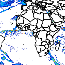
Oya is a quasi-global, high-resolution precipitation estimation dataset derived from geostationary (GEO) satellite observations.
The Oya model utilizes the full spectrum of visible and infrared (VIS-IR) channels from a constellation of GEO satellites — including GOES-16/18, Meteosat-9/10, and Himawari-8/9 — to generate precipitation estimates covering 60°N to 60°S.
To address the inherent data imbalance between rain and no-rain events, Oya employs a two-stage deep learning approach. It combines two U-Net models: one specialized for precipitation detection and another for Quantitative Precipitation Estimation (QPE). The models are trained using high-resolution GPM Combined Radar-Radiometer Algorithm (CORRA) v07 data as ground truth and are pre-trained on IMERG-Final retrievals to enhance robustness.
Oya demonstrates superior performance compared to existing operational GEO-based baselines, such as the PERSIANN DynamicInfrared Rain Rate (PDIR-Now) and the Convective Rainfall Rate (CRR), across all precipitation intensities. It also outperforms Passive Microwave (PMW) based products like the Integrated Multisatellite Retrievals for GPM (IMERG) Early and is competitive with research-grade products like IMERG Final, which has a 3.5-month latency. This dataset includes a half-hourly historical record generated from 2004 with a spatial resolution of 5km.
Limitations:
- Geographic Decline: Retrieval accuracy is highest in tropical zones and degrades at higher latitudes. This is attributed to geostationary satellite viewing angle effects, specifically limb darkening and parallax shift.
- Topographic Challenges: The model shows reduced performance in arid and high-altitude regions, notably the Tibetan Plateau.
- Indirect Observation: As an IR/VIS-based product, Oya infers precipitation from cloud-top properties rather than directly sensing raindrops (as radar or passive microwave instruments do).
Google makes no commitment about future updates to this dataset.
Note: The associated paper, Oya: Deep Learning for Accurate Global Precipitation Estimation, has not yet gone through formal peer review. It would be released on arxiv soon.
Bands
Bands
Pixel size: 5000 meters (all bands)
| Name | Units | Pixel Size | Description |
|---|---|---|---|
precipitation |
mm/hr | 5000 meters | Precipitation estimate |
Image Properties
Image Properties
| Name | Type | Description |
|---|---|---|
| ingestion_time_utc | STRING | The time of ingestion. |
Terms of Use
Terms of Use
Explore with Earth Engine
Code Editor (JavaScript)
var imageCollection = ee.ImageCollection(
  "projects/global-precipitation-nowcast/assets/global_estimation"
);

// Select a single estimate.
var singleEstimate = imageCollection.filterDate('2022-12-30T12-00').first();
// mask to remove 0 values
var masked = singleEstimate.selfMask();


// Display on map.
var visParams = {
  min: 0,
  max: 15,
  palette: [
    '000096','0064ff', '00b4ff', '33db80', '9beb4a',
    'ffeb00', 'ffb300', 'ff6400', 'eb1e00', 'af0000'
  ]
};

Map.addLayer(
  masked,
  visParams,
  "Preciptation retrieval for 2022-12-30T12-00 in mm/hr"
);