Page Summary
-
The dataset contains 30m resolution raster files for 2020 Canadian forest data, including land cover, canopy height, crown closure, aboveground tree biomass, and species composition.
-
SCANFI was developed using National Forest Inventory photo-plot data and Landsat imagery with a k-nearest neighbours and random forest imputation method.
-
Data for Arctic ecozones were predicted using a single random forest model and could not be rigorously validated.
-
The dataset has limitations regarding pest-disturbed areas, open stand class estimates, tree species cover predictions, and reliability in Yukon.
-
The dataset is licensed under the Open Government Licence - Canada and can be downloaded from Canada's "Open Government" website.

- Catalog Owner
- Canadian Forest Earth Observation Products
- Dataset Availability
- 2020-01-01T00:00:00Z–2021-01-01T00:00:00Z
- Dataset Producer
- NRCan
- Contact
- Laurentian Forestry Center, Remote Sensing Lab
- Tags
Description
This data publication contains a set of 30m resolution raster files representing 2020 Canadian wall-to-wall maps of broad land cover type, forest canopy height, degree of crown closure and aboveground tree biomass, along with species composition of several major tree species. The Spatialized CAnadian National Forest Inventory data product (SCANFI) was developed using the newly updated National Forest Inventory photo-plot dataset, which consists of a regular sample grid of photo-interpreted high-resolution imagery covering all of Canada’s non-arctic landmass. SCANFI was produced using temporally harmonized summer and winter Landsat spectral imagery along with hundreds of tile-level regional models based on a novel k-nearest neighbours and random forest imputation method.
A full description of all methods and validation analyses can be found in Guindon et al. (2024). As the Arctic ecozones are outside NFI’s covered areas, the vegetation attributes in these regions were predicted using a single random forest model. The vegetation attributes in these arctic areas could not be rigorously validated. The "articExtrapolationArea" band identifies these zones.
Data limitations:
The spectral disturbances of some areas disturbed by pests are not comprehensively represented in the training set, thus making it impossible to predict all defoliation cases. One such area, severely impacted by the recent eastern spruce budworm outbreak, is located on the North Shore of the St-Lawrence River. These forests are misrepresented in our training data, there is therefore an imprecision in the estimates.
Attributes of open stand classes, namely shrub, herbs, rock and bryoid, are more difficult to estimate through the photointerpretation of aerial images. Therefore, these estimates could be less reliable than the forest attribute estimates.
As reported in the manuscript, the uncertainty of tree species cover predictions is relatively high. This is particularly true for less abundant tree species, such as ponderosa pine and tamarack. The tree species layers are therefore suitable for regional and coarser scale studies. Also, the broadleaf proportion are slightly underestimated in this product version.
Our validation indicates that the areas in Yukon exhibit a notably lower R2 value. Consequently, estimates within these regions are less dependable.
Urban areas and roads are classified as rock, according to the 2020 Agriculture and Agri-Food Canada land-use classification map. Even though those areas contain mostly buildings and infrastructure, they may also contain trees. Forested urban parks are usually classified as forested areas. Vegetation attributes are also predicted for forested areas in agricultural regions.
This dataset can also be downloaded from Canada's "Open Government" website.
Contains information licensed under the Open Government Licence - Canada
Bands
Pixel Size
30 meters
Bands
| Name | Units | Pixel Size | Description |
|---|---|---|---|
biomass |
tonnes/hectare | meters | Aboveground tree biomass: biomass derived from total merchantable volume estimates produced by provincial agencies |
closure |
% | meters | Crown closure (%): percentage of pixel covered by the tree canopy |
height |
m | meters | Height (meters): vegetation height |
nfiLandCover |
meters | NFI land cover class values: Land cover classes include Bryoid (1), Herbs (2), Rock (3), Shrub (4), Treed broadleaf (5), Treed conifer (6), Treed mixed (7) and Water (8) |
|
balsamFir |
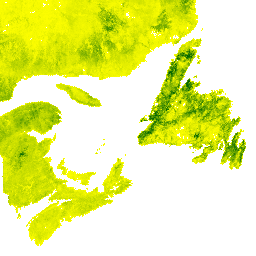
% | meters | Balsam fir (%): estimated as the proportion of the canopy covered by Abies balsamea |
blackSpruce |
% | meters | Black spruce (%): estimated as the proportion of the canopy covered by Picea mariana |
douglasFir |
% | meters | Douglas fir (%): estimated as the proportion of the canopy covered by Pseudotsuga menziesii |
jackPine |
% | meters | Jack pine (%): estimated as the proportion of the canopy covered by Pinus banksiana |
lodgepolePine |
% | meters | Lodgepole pine (%): estimated as the proportion of the canopy covered by Pinus contorta |
ponderosaPine |
% | meters | Ponderosa pine (%): estimated as the proportion of the canopy covered by Pinus ponderosa |
prcB |
% | meters | Broadleaf tree cover in percentage (PrcB) |
prcC |
% | meters | Other coniferous tree cover in percentage (PrcC) |
tamarack |
% | meters | Tamarack_tree (%): estimated as the proportion of the canopy covered by Larix laricina |
whiteRedPine |
% | meters | White and red pine (%): estimated as the proportion of the canopy covered by Pinus strobus and Pinus resinosa |
articExtrapolationArea |
meters | Flag for marking Arctic unreliable extrapolated pixels |
nfiLandCover Class Table
| Value | Color | Description |
|---|---|---|
| 1 | #e64bfa | Bryoid |
| 2 | #e7e56c | Herbs |
| 3 | #000000 | Rock |
| 4 | #bd0006 | Shrub |
| 5 | #95ea4b | Treed broadleaf |
| 6 | #048e4e | Coniferous |
| 7 | #16d132 | Treed mixed |
| 8 | #3be5ff | Water |
articExtrapolationArea Class Table
| Value | Color | Description |
|---|---|---|
| 1 | #000000 | Artic Extrapolation Area |
Terms of Use
Terms of Use
Licensed under the Open Government Licence - Canada.
Citations
Guindon L., Villemaire P., Correia D.L.P., Manka F., Lacarte S., Smiley B. 2023. SCANFI: Spatialized CAnadian National Forest Inventory data product. Natural Resources Canada, Canadian Forest Service, Laurentian Forestry Centre, Quebec, Canada. https://doi.org/10.23687/18e6a919-53fd-41ce-b4e2-44a9707c52dc
Guindon, L., Manka, F., Correia, D.L.P., Villemaire, P., Smiley, B., Bernier, P., Gauthier, S., Beaudoin, A., Boucher, J., and Boulanger, Y. 2024. A new approach for Spatializing the Canadian National Forest Inventory (SCANFI) using Landsat dense time series. Can. J. For. Res. https://doi.org/10.1139/cjfr-2023-0118
Explore with Earth Engine
Code Editor (JavaScript)
var dataset = ee.Image("projects/gcpm041u-lemur/assets/scanfi_v12/SCANFI_v1_2");
var balsamFir = dataset.select('balsamFir').selfMask();
var vis = {
  min: 0,
  max: 100,
  palette: ['yellow', 'darkgreen']
};
Map.setCenter(-94, 56, 5);
Map.addLayer(balsamFir, vis, 'Balsam Fir Percentage')
