- ความพร้อมใช้งานของชุดข้อมูล
- 2003-01-01T00:00:00Z–2018-12-31T00:00:00Z
- ผู้ผลิตชุดข้อมูล
- ศูนย์สังเกตการณ์โลกของเยล (Yale Center for Earth Observation หรือ YCEO)
- แท็ก
คำอธิบาย
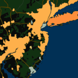
ชุดข้อมูลนี้ประกอบด้วยความเข้มของเกาะความร้อนในเมือง (SUHI) ที่พื้นผิวในฤดูร้อนและฤดูหนาวประจำปีสำหรับกลางวันและกลางคืนสำหรับกลุ่มเมืองกว่า 10,000 กลุ่มทั่วโลก ชุดข้อมูลนี้สร้างขึ้นโดยใช้ผลิตภัณฑ์อุณหภูมิพื้นผิวดิน (LST) ของ TERRA และ AQUA แบบ 8 วันของ MODIS, ฐานข้อมูลขอบเขตเมือง Landscan, ข้อมูลระดับความสูงของภูมิประเทศแบบหลายความละเอียดทั่วโลกปี 2010 และข้อมูล การปกคลุมของพื้นดินจากโครงการริเริ่มด้านการเปลี่ยนแปลงสภาพภูมิอากาศ (CCI) ขององค์การอวกาศยุโรป (ESA) โดยใช้อัลกอริทึมขอบเขตเมืองแบบย่อ ผลิตภัณฑ์นี้มีให้บริการทั้งในระดับพิกเซล (ที่ความละเอียด 300 ม. หลังจากลดขนาด) และเป็นกลุ่มเมือง ตั้งแต่ปี 2003 ถึง 2018 ข้อมูลผสมรายเดือนจะใช้ได้เฉพาะในรูปแบบของคลัสเตอร์ในเมือง เท่านั้น
สรุปเวอร์ชันเก่า รวมถึงการเปลี่ยนแปลงจากชุดข้อมูลที่สร้างและวิเคราะห์ในต้นฉบับที่เผยแพร่ ครั้งแรกสามารถดูได้ในเว็บไซต์ของ Yale Center for Earth Observation นอกจากนี้ คุณยังสำรวจชุดข้อมูลได้โดยใช้เว็บแอปพลิเคชัน Global Surface UHI Explorer
ชุดข้อมูลแบ่งออกเป็น 6 องค์ประกอบต่อไปนี้
UHI_all_averaged: รูปภาพที่มีความเข้มของ SUHI ในช่วงกลางวันและกลางคืนแบบคอมโพสิตที่มีค่าเฉลี่ยของคลัสเตอร์ สำหรับฤดูร้อน ฤดูหนาว และทั้งปี
UHI_monthly_averaged: รูปภาพที่มีค่าเฉลี่ยคลัสเตอร์ คอมโพสิตรายเดือนของความเข้ม SUHI ในเวลากลางวันและกลางคืน
UHI_yearly_averaged: คอลเล็กชันรูปภาพของค่าเฉลี่ยคลัสเตอร์ แบบรายปีของความเข้ม SUHI ในเวลากลางวันและกลางคืนตั้งแต่ปี 2003 ถึง 2018
UHI_yearly_pixel: คอลเล็กชันรูปภาพของความเข้ม SUHI ในช่วงกลางวันและกลางคืนรายปีที่แยกตามพื้นที่ (มาตราส่วนที่กำหนด 300 ม.) ตั้งแต่ปี 2003 ถึง 2018
Summer_UHI_yearly_pixel: คอลเล็กชันรูปภาพของความเข้ม SUHI ในช่วงกลางวันและกลางคืนของฤดูร้อนที่แยกตามพื้นที่ (มาตราส่วนที่กำหนด 300 ม.) ตั้งแต่ปี 2003 ถึง 2018
Winter_UHI_yearly_pixel: คอลเล็กชันรูปภาพของความเข้มของ SUHI ในช่วงกลางวันและกลางคืนของฤดูหนาวที่แยกตามพื้นที่ (มาตราส่วนที่กำหนด 300 ม.) ตั้งแต่ปี 2003 ถึง 2018
เนื้อหานี้เป็นคอมโพเนนต์ที่ 2
ย่านความถี่
ย่านความถี่
ขนาดพิกเซล: 300 เมตร (ทุกแถบความถี่)
| ชื่อ | หน่วย | ขนาดพิกเซล | คำอธิบาย |
|---|---|---|---|
Jan_day_UHI |
°C | 300 เมตร | UHI ในเวลากลางวันของเดือนมกราคม |
Jan_night_UHI |
°C | 300 เมตร | UHI ในช่วงกลางคืนของเดือนมกราคม |
Feb_day_UHI |
°C | 300 เมตร | UHI ในช่วงกลางวันของเดือนกุมภาพันธ์ |
Feb_night_UHI |
°C | 300 เมตร | UHI ในเวลากลางคืนของเดือนกุมภาพันธ์ |
Mar_day_UHI |
°C | 300 เมตร | UHI ในช่วงกลางวันของเดือนมีนาคม |
Mar_night_UHI |
°C | 300 เมตร | UHI ในเวลากลางคืนของเดือนมีนาคม |
Apr_day_UHI |
°C | 300 เมตร | UHI ช่วงกลางวันในเดือนเมษายน |
Apr_night_UHI |
°C | 300 เมตร | UHI ในเวลากลางคืนของเดือนเมษายน |
May_day_UHI |
°C | 300 เมตร | UHI ช่วงกลางวันในเดือนพฤษภาคม |
May_night_UHI |
°C | 300 เมตร | UHI ในช่วงกลางคืนของเดือนพฤษภาคม |
Jun_day_UHI |
°C | 300 เมตร | UHI ในเวลากลางวันของเดือนมิถุนายน |
Jun_night_UHI |
°C | 300 เมตร | UHI ในช่วงกลางคืนของเดือนมิถุนายน |
Jul_day_UHI |
°C | 300 เมตร | UHI ตอนกลางวันในเดือนกรกฎาคม |
Jul_night_UHI |
°C | 300 เมตร | UHI ในช่วงกลางคืนของเดือนกรกฎาคม |
Aug_day_UHI |
°C | 300 เมตร | UHI ในช่วงกลางวันของเดือนสิงหาคม |
Aug_night_UHI |
°C | 300 เมตร | UHI ในเวลากลางคืนของเดือนสิงหาคม |
Sep_day_UHI |
°C | 300 เมตร | UHI ในช่วงกลางวันของเดือนกันยายน |
Sep_night_UHI |
°C | 300 เมตร | UHI ในช่วงกลางคืนของเดือนกันยายน |
Oct_day_UHI |
°C | 300 เมตร | UHI ในช่วงกลางวันของเดือนตุลาคม |
Oct_night_UHI |
°C | 300 เมตร | UHI ในช่วงกลางคืนของเดือนตุลาคม |
Nov_day_UHI |
°C | 300 เมตร | UHI ในช่วงกลางวันของเดือนพฤศจิกายน |
Nov_night_UHI |
°C | 300 เมตร | UHI ในช่วงกลางคืนของเดือนพฤศจิกายน |
Dec_day_UHI |
°C | 300 เมตร | UHI ในช่วงกลางวันของเดือนธันวาคม |
Dec_night_UHI |
°C | 300 เมตร | UHI ในเวลากลางคืนของเดือนธันวาคม |
ข้อกำหนดในการใช้งาน
ข้อกำหนดในการใช้งาน
การอ้างอิง
Chakraborty, T., & Lee, X. (2019). อัลกอริทึมขอบเขตเมืองแบบง่าย เพื่อระบุลักษณะเกาะความร้อนในเมืองบนพื้นผิวในระดับโลกและตรวจสอบ การควบคุมพืชพรรณในความแปรปรวนเชิงพื้นที่และเวลา International Journal of Applied Earth Observation and Geoinformation, 74, 269-280. doi:10.1016/j.jag.2018.09.015
สำรวจด้วย Earth Engine
ตัวแก้ไขโค้ด (JavaScript)
var dataset = ee.Image('YALE/YCEO/UHI/UHI_monthly_averaged/v4');

var visualization = {
  bands: ['Jan_day_UHI'],
  min: -1.5,
  max: 7.5,
  palette: [
    '313695', '74add1', 'fed976', 'feb24c', 'fd8d3c', 'fc4e2a', 'e31a1c',
    'b10026']
};

Map.setCenter(-74.7, 40.6, 7);

Map.addLayer(dataset, visualization, 'January Daytime UHI');