A. Baccini, S J. Goetz, W.S. Walker, N. T. Laporte, M. Sun, D.
Sulla-Menashe, J. Hackler, P.S.A. Beck, R. Dubayah, M.A. Friedl, S. Samanta 和 R. A. 霍顿。利用碳密度地图改进了热带森林砍伐的二氧化碳排放量估算。2012 年《自然气候变化》,doi:10.1038/NCLIMATE1354
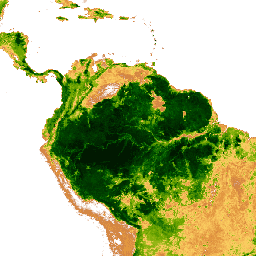
[[["易于理解","easyToUnderstand","thumb-up"],["解决了我的问题","solvedMyProblem","thumb-up"],["其他","otherUp","thumb-up"]],[["没有我需要的信息","missingTheInformationINeed","thumb-down"],["太复杂/步骤太多","tooComplicatedTooManySteps","thumb-down"],["内容需要更新","outOfDate","thumb-down"],["翻译问题","translationIssue","thumb-down"],["示例/代码问题","samplesCodeIssue","thumb-down"],["其他","otherDown","thumb-down"]],[],[],["The WHRC provides a dataset of above-ground live woody biomass density for tropical countries, captured on January 29, 2012, at a 500-meter pixel resolution. The data, derived from field measurements, LiDAR, and MODIS imagery, is available through Google Earth Engine using the `ee.Image(\"WHRC/biomass/tropical\")` snippet. Users are allowed to use the dataset for scientific, conservation, and educational purposes while providing feedbacks on errors. The dataset is measured in Megagrams per hectare (Mg/ha) with values from 0 to 503.\n"]]