- Доступность набора данных
- 2012-02-07T00:00:00Z–2012-02-07T00:00:00Z
- Производитель наборов данных
- Геологическая служба США
- Теги
- дем
Описание
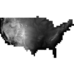
Национальный набор данных о высотах (NED) ранее был* основным продуктом данных о высотах Геологической службы США (USGS). NED представляет собой единый набор данных, содержащий лучшие доступные растровые данные о высотах континентальной части Соединенных Штатов, частей Аляски, Гавайев и некоторых территориальных островов. NED формируется из различных исходных данных, которые обрабатываются в единую систему координат и единицу вертикального измерения. Данные NED распространяются в соответствии с Североамериканской системой координат 1983 года (NAD 83). Все значения высоты указаны в метрах и на территории континентальной части Соединенных Штатов привязаны к Североамериканской вертикальной системе координат 1988 года (NAVD 88). Вертикальная привязка может отличаться в других районах.
*Более 15 лет NED был основным продуктом данных о высотах на Национальной карте Геологической службы США. Однако после начала работы Программы 3D-моделирования высот он был переименован и теперь рассматривается лишь как один из компонентов данных о высотах на Национальной карте.
Группы
Группы
Размер пикселя: 10,2 метра (все диапазоны)
| Имя | Единицы | Мин | Макс | Размер пикселя | Описание |
|---|---|---|---|---|---|
elevation | м | -85.61* | 4414.22* | 10,2 метра | Высота |
Условия эксплуатации
Условия эксплуатации
Большая часть информации Геологической службы США (USGS) находится в открытом доступе и может использоваться без ограничений. Дополнительная информация о том, как указывать USGS в качестве источника информации, доступна по ссылке.
Цитаты
Национальный набор данных о высотах Геологической службы США предоставлен Геологической службой США.
Исследуйте мир с помощью Earth Engine.
Редактор кода (JavaScript)
var dataset = ee.Image('USGS/NED');
var elevation = dataset.select('elevation');
var elevationVis = {
  min: 0.0,
  max: 4000.0,
  gamma: 1.6,
};
Map.setCenter(-100.55, 40.71, 5);
Map.addLayer(elevation, elevationVis, 'Elevation');