- Ketersediaan Set Data
- 2010-01-01T00:00:00Z–2010-01-01T00:00:00Z
- Produsen Set Data
- USGS
- Tag
Deskripsi
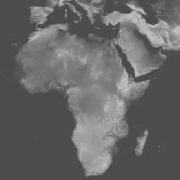
Set data Global Multi-resolution Terrain Elevation Data 2010 (GMTED2010) berisi data elevasi untuk seluruh dunia yang dikumpulkan dari berbagai sumber. Versi set data yang tersedia di sini adalah Breakline Emphasis, resolusi 7,5 detik busur. Penekanan garis batas mempertahankan fitur topografi penting (sungai atau punggung bukit) dalam lanskap dengan mempertahankan nilai elevasi minimum atau nilai elevasi maksimum pada garis batas yang melewati jendela analisis yang ditentukan. Detail selengkapnya tersedia di laporan set data.
Kumpulan data sumber utama untuk GMTED2010 adalah Data Ketinggian Medan Digital SRTM NGA (DTED®, https://www2.jpl.nasa.gov/srtm/) (diisi dengan data yang tidak valid) 1 detik busur. Untuk area geografis di luar area cakupan SRTM dan untuk mengisi lubang yang tersisa dalam data SRTM, sumber berikut digunakan: DTED® non-SRTM, Canadian Digital Elevation Data (CDED) pada dua resolusi, Satellite Pour l''Observation de la Terre (SPOT 5) Reference3D, National Elevation Dataset (NED) untuk Amerika Serikat kontinental dan Alaska, model elevasi digital (DEM) 9 detik GEODATA untuk Australia, DEM altimeter laser dan radar satelit Antartika, serta DEM altimeter radar satelit Greenland.
Set data ini menggantikan Model Ketinggian GTOPO30.
Band
Band
Ukuran piksel: 231,92 meter (semua band)
| Nama | Unit | Min | Maks | Ukuran Piksel | Deskripsi |
|---|---|---|---|---|---|
be75 |
m | -457* | 8746* | 231,92 meter | Elevasi |
Persyaratan Penggunaan
Persyaratan Penggunaan
Sebagian besar informasi United States Geological Survey (USGS) berada di domain publik dan dapat digunakan tanpa batasan. Informasi tambahan tentang Mengakui atau Mengatribusikan USGS sebagai Sumber Informasi tersedia.
Kutipan
Data Ketinggian Medan Multi-resolusi Global 2010 atas izin Survei Geologi Amerika Serikat
Mengeksplorasi dengan Earth Engine
Editor Kode (JavaScript)
var dataset = ee.Image('USGS/GMTED2010');
var elevation = dataset.select('be75');
var elevationVis = {
  min: -100.0,
  max: 6500.0,
  gamma: 3.5,
};
Map.setCenter(17.93, 7.71, 2);
Map.addLayer(elevation, elevationVis, 'Elevation');