Page Summary
-
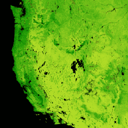
The MODIS Net Primary Production (NPP) CONUS dataset provides estimates of net primary production for the conterminous United States.
-
NPP represents the carbon captured by plants after accounting for respiration losses.
-
This dataset uses the MOD17 algorithm, MODIS Surface Reflectance, gridMET, and the National Land Cover Database for calculation.
-
The dataset is available annually from 2001 to 2019 with a pixel size of 250 meters.
-
The data includes bands for annual NPP in kg*C/m^2 and a QC band indicating the percentage of gap-filled NDVI values.
- Dataset Availability
- 2001-01-01T00:00:00Z–2019-01-01T00:00:00Z
- Dataset Producer
- University of Montana Numerical Terradynamic Simulation Group (NTSG)
- Cadence
- 1 Year
- Tags
Description
The MODIS Net Primary Production (NPP) CONUS dataset estimates NPP using MODIS Surface Reflectance for CONUS. NPP is the amount of carbon captured by plants in an ecosystem, after accounting for losses due to respiration. NPP is calculated using the MOD17 algorithm (see MOD17 User Guide) with MODIS Surface Reflectance, gridMET, and the National Land Cover Database.
Bands
Bands
Pixel size: 250 meters (all bands)
| Name | Units | Min | Max | Scale | Pixel Size | Description |
|---|---|---|---|---|---|---|
annualNPP |
kg*C/m^2 | 0 | 65535 | 0.0001 | 250 meters | Annual net primary productivity |
QC |
% | 0 | 100 | 250 meters | Percentage of gap-filled NDVI values. |
Terms of Use
Terms of Use
This work is in the public domain and is free of known copyright restrictions. Users should properly cite the source used in the creation of any reports and publications resulting from the use of this dataset and note the date when the data was acquired.
Citations
Robinson, N.P., B.W. Allred, W.K. Smith, M.O. Jones, A. Moreno, T.A. Erickson, D.E. Naugle, and S.W. Running. 2018. Terrestrial primary production for the conterminous United States derived from Landsat 30 m and MODIS 250 m. Remote Sensing in Ecology and Conservation. doi:10.1002/rse2.74
Explore with Earth Engine
Code Editor (JavaScript)
var dataset = ee.ImageCollection('UMT/NTSG/v2/MODIS/NPP')
                  .filter(ee.Filter.date('2016-01-01', '2016-12-31'));
var npp = dataset.select('annualNPP');
var nppVis = {
  min: 0.0,
  max: 20000.0,
  palette: ['bbe029', '0a9501', '074b03'],
};
Map.setCenter(-98.26, 39.32, 5);
Map.addLayer(npp, nppVis, 'NPP');