Page Summary
-
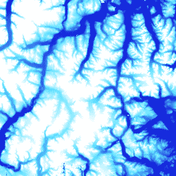
This dataset, ArcticDEM V2/5m, is a digital surface model (DSM) providing first-return elevation values including surface features like vegetation and buildings, but it has been superseded by a newer version.
-
The 2m asset within this dataset is a collection of strips, not a single mosaic, due to projection differences between them.
-
The dataset includes
elevationandmatchtagbands with a pixel size of 5 meters. -
Use of this data requires citing the Polar Geospatial Center (PGC) and acknowledging its sponsorship by the National Science Foundation (NSF).
- Dataset Availability
- 2016-09-21T00:00:00Z–2016-09-21T00:00:00Z
- Dataset Producer
- University of Minnesota Polar Geospatial Center
- Tags
Description
ArcticDEM is a digital surface model (DSM) that portrays first-return elevation values that include vegetation, tree canopy, buildings, and other man-made surface features. The 2m asset is a collection of strips rather than a single mosaic due to projection differences between strips.
Mosaicked DEM files are compiled from the best quality strip DEM files which have been blended and feathered to reduce void areas and edge-matching artifacts. Filtered IceSAT altimetry data has been applied to the raster files to improve absolute accuracy.
Bands
Bands
Pixel size: 5 meters (all bands)
| Name | Units | Min | Max | Pixel Size | Description | ||||||||||||||||||||||||||||||||||||||||||||||||||||||||||||||||||||||||||||||||||||||||||||||
|---|---|---|---|---|---|---|---|---|---|---|---|---|---|---|---|---|---|---|---|---|---|---|---|---|---|---|---|---|---|---|---|---|---|---|---|---|---|---|---|---|---|---|---|---|---|---|---|---|---|---|---|---|---|---|---|---|---|---|---|---|---|---|---|---|---|---|---|---|---|---|---|---|---|---|---|---|---|---|---|---|---|---|---|---|---|---|---|---|---|---|---|---|---|---|---|---|---|---|---|
elevation |
m | -416.45* | 5971.24* | 5 meters | Elevation |
||||||||||||||||||||||||||||||||||||||||||||||||||||||||||||||||||||||||||||||||||||||||||||||
matchtag |
5 meters | Bitmask raster indicating DEM pixels derived from a stereo match (1) or those that have been interpolated (0) |
|||||||||||||||||||||||||||||||||||||||||||||||||||||||||||||||||||||||||||||||||||||||||||||||||
Terms of Use
Terms of Use
National Science Foundation (PGC's primary funding source) policy requires researchers to acknowledge NSF support in all publications, web pages, and media interviews.
By using PGC data in Earth Engine, users agree to cite PGC and its sponsorship by the NSF. The original source of any third-party data supplied by PGC must also be properly attributed.
For more information see the PGC's Acknowledgement Policy.
Citations
DEM(s) created by the Polar Geospatial Center from DigitalGlobe, Inc. imagery.
Explore with Earth Engine
Code Editor (JavaScript)
var dataset = ee.Image('UMN/PGC/ArcticDEM/V2/5m');
var elevation = dataset.select('elevation');
var elevationVis = {
  min: -50.0,
  max: 1000.0,
  palette: ['0d13d8', '60e1ff', 'ffffff'],
};
Map.setCenter(-63.402, 66.368, 7);
Map.addLayer(elevation, elevationVis, 'Elevation');