Page Summary
-
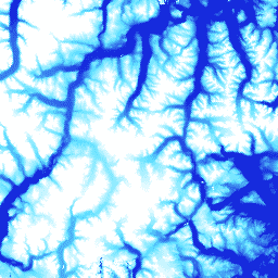
This dataset is a digital surface model (DSM) showing first-return elevation values including features like vegetation, tree canopy, and buildings.
-
The 2m asset is a collection of strips, not a single mosaic, due to projection differences.
-
Strip DEM files correspond to the overlapping area of input stereopair image swaths from polar-orbiting satellites.
-
Users must cite the Polar Geospatial Center (PGC) and its sponsorship by the NSF when using this data in Earth Engine.
- Dataset Availability
- 2009-08-16T00:00:00Z–2017-03-12T00:00:00Z
- Dataset Producer
- University of Minnesota Polar Geospatial Center
- Tags
Description
ArcticDEM is a digital surface model (DSM) that portrays first-return elevation values that include vegetation, tree canopy, buildings, and other man-made surface features. The 2m asset is a collection of strips rather than a single mosaic due to projection differences between strips.
Strip DEM files correspond to the overlapping area of the input stereopair image swaths as they are collected by DigitalGlobe's constellation of polar-orbiting satellites. Strip DEM dimensions will vary according to the satellite sensor that acquired the images and the off-nadir angle of collection. Most strips are between 16km and 18km in width, and 110km and 120km in length.
Bands
Bands
Pixel size: 2 meters (all bands)
| Name | Units | Pixel Size | Description | ||||||||||||||||||||||||||||||||||||||||||||||||||||||||||||||||||||||||||||||||||||||||||||||||
|---|---|---|---|---|---|---|---|---|---|---|---|---|---|---|---|---|---|---|---|---|---|---|---|---|---|---|---|---|---|---|---|---|---|---|---|---|---|---|---|---|---|---|---|---|---|---|---|---|---|---|---|---|---|---|---|---|---|---|---|---|---|---|---|---|---|---|---|---|---|---|---|---|---|---|---|---|---|---|---|---|---|---|---|---|---|---|---|---|---|---|---|---|---|---|---|---|---|---|---|
elevation |
m | 2 meters | Elevation |
||||||||||||||||||||||||||||||||||||||||||||||||||||||||||||||||||||||||||||||||||||||||||||||||
matchtag |
2 meters | Bitmask raster indicating DEM pixels processing |
|||||||||||||||||||||||||||||||||||||||||||||||||||||||||||||||||||||||||||||||||||||||||||||||||
Terms of Use
Terms of Use
National Science Foundation (PGC's primary funding source) policy requires researchers to acknowledge NSF support in all publications, web pages, and media interviews.
By using PGC data in Earth Engine, users agree to cite PGC and its sponsorship by the NSF. The original source of any third-party data supplied by PGC must also be properly attributed.
For more information see the PGC's Acknowledgement Policy.
Citations
DEM(s) created by the Polar Geospatial Center from DigitalGlobe, Inc. imagery.
Explore with Earth Engine
Code Editor (JavaScript)
var dataset = ee.ImageCollection('UMN/PGC/ArcticDEM/V2/2m');
var elevation = dataset.select('elevation');
var elevationVis = {
  min: -50.0,
  max: 1000.0,
  palette: ['0d13d8', '60e1ff', 'ffffff'],
};
Map.setCenter(-63.402, 66.368, 7);
Map.addLayer(elevation, elevationVis, 'Elevation');