Page Summary
-
This gap-filled Tasseled Cap Brightness (TCB) dataset, produced by the Malaria Atlas Project, covers the period from 2001 to 2015 and is derived from MODIS imagery with gap-filling applied.
-
The dataset is available monthly at a 5km pixel size and includes bands for the mean TCB value and the proportion of original data versus gap-filled estimates.
-
This dataset is licensed under CC-BY-NC-SA-4.0 and citations are provided for the gap-filling and tasseled cap methodologies used.
-
This dataset has been superseded by a newer version at a higher resolution.
- Dataset Availability
- 2001-02-01T00:00:00Z–2015-01-01T00:00:00Z
- Dataset Producer
- Oxford Malaria Atlas Project
- Cadence
- 1 Month
- Tags
Description
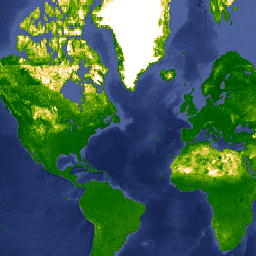
This gap-filled Tasseled Cap Brightness (TCB) dataset was created by applying the tasseled-cap equations defined in Lobser and Cohen (2007) to MODIS BRDF-corrected imagery (MCD43B4). The resulting data were gap-filled using the approach outlined in Weiss et al. (2014) to eliminate missing data caused by factors such as cloud cover, and then the data were aggregated temporally and spatially to produce the monthly ≈5km product.
This dataset was produced by Harry Gibson and Daniel Weiss of the Malaria Atlas Project.
Bands
Bands
Pixel size: 5000 meters (all bands)
| Name | Units | Min | Max | Pixel Size | Description |
|---|---|---|---|---|---|
Mean |
0* | 1.99* | 5000 meters | The mean value of Tasseled Cap Brightness for each aggregated pixel. |
|
FilledProportion |
% | 0* | 100* | 5000 meters | A quality control band that indicates the percentage of each resulting pixel that was comprised of raw data (as opposed to gap-filled estimates). |
Terms of Use
Terms of Use
Citations
Weiss, D.J., P.M. Atkinson, S. Bhatt, B. Mappin, S.I. Hay & P.W. Gething (2014) An effective approach for gap-filling continental scale remotely sensed time-series. ISPRS Journal of Photogrammetry and Remote Sensing, 98, 106-118.
Lobser, S.E. & Cohen, W.B. (2007) MODIS tasselled cap: land cover characteristics expressed through transformed MODIS data. International Journal of Remote Sensing, 28, 5079-5101.
Explore with Earth Engine
Code Editor (JavaScript)
var dataset = ee.ImageCollection('Oxford/MAP/TCB_5km_Monthly')
                  .filter(ee.Filter.date('2013-01-01', '2013-12-31'));
var tcb = dataset.select('Mean');
var tcbVis = {
  min: 0.0,
  max: 1.3,
  palette: [
    '011301', '004c00', '056201', '207401', '3e8601', '66a000', '99b718',
    'fcd163', 'ffffff'
  ],
};
Map.setCenter(-44.65, 22.59, 2);
Map.addLayer(tcb, tcbVis, 'TCB');