- ความพร้อมใช้งานของชุดข้อมูล
- 1950-01-01T00:00:00Z–2018-01-01T00:00:00Z
- ผู้ผลิตชุดข้อมูล
- EnvirometriX Ltd
- แท็ก
คำอธิบาย
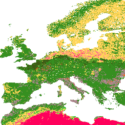
ระดับเนื้อดิน (ระบบ USDA) สำหรับความลึกของดิน 6 ระดับ (0, 10, 30, 60, 100 และ 200 ซม.) ที่ 250 ม.
ได้มาจากเศษส่วนของเนื้อดินที่คาดการณ์ไว้โดยใช้แพ็กเกจ soiltexture ใน R ดูขั้นตอนการประมวลผลโดยละเอียดได้ที่นี่ ไม่รวมทวีปแอนตาร์กติกา
หากต้องการเข้าถึงและแสดงภาพแผนที่ภายนอก Earth Engine ให้ใช้หน้านี้
หากพบข้อบกพร่อง อาร์ติแฟกต์ หรือความไม่สอดคล้องกันในแผนที่ LandGIS หรือหากมีคำถาม โปรดใช้ช่องทางต่อไปนี้
ย่านความถี่
ย่านความถี่
ขนาดพิกเซล: 250 เมตร (ทุกแถบ)
| ชื่อ | ขนาดพิกเซล | คำอธิบาย |
|---|---|---|
b0 |
250 เมตร | คลาสเนื้อดิน (ระบบ USDA) ที่ความลึก 0 ซม. |
b10 |
250 เมตร | ชั้นเนื้อดิน (ระบบ USDA) ที่ความลึก 10 ซม. |
b30 |
250 เมตร | ชั้นเนื้อดิน (ระบบ USDA) ที่ความลึก 30 ซม. |
b60 |
250 เมตร | ระดับเนื้อดิน (ระบบ USDA) ที่ความลึก 60 ซม. |
b100 |
250 เมตร | ระดับเนื้อดิน (ระบบ USDA) ที่ความลึก 100 ซม. |
b200 |
250 เมตร | ระดับเนื้อดิน (ระบบ USDA) ที่ความลึก 200 ซม. |
ตารางคลาส b0
| ค่า | สี | คำอธิบาย |
|---|---|---|
| 1 | #d5c36b | Cl |
| 2 | #b96947 | SiCl |
| 3 | #9d3706 | SaCl |
| 4 | #ae868f | ClLo |
| 5 | #f86714 | SiClLo |
| 6 | #46d143 | SaClLo |
| 7 | #368f20 | Lo |
| 8 | #3e5a14 | SiLo |
| 9 | #ffd557 | SaLo |
| 10 | #fff72e | Si |
| 11 | #ff5a9d | LoSa |
| 12 | #ff005b | ส. |
ตารางคลาส b10
| ค่า | สี | คำอธิบาย |
|---|---|---|
| 1 | #d5c36b | Cl |
| 2 | #b96947 | SiCl |
| 3 | #9d3706 | SaCl |
| 4 | #ae868f | ClLo |
| 5 | #f86714 | SiClLo |
| 6 | #46d143 | SaClLo |
| 7 | #368f20 | Lo |
| 8 | #3e5a14 | SiLo |
| 9 | #ffd557 | SaLo |
| 10 | #fff72e | Si |
| 11 | #ff5a9d | LoSa |
| 12 | #ff005b | ส. |
ตารางคลาส b30
| ค่า | สี | คำอธิบาย |
|---|---|---|
| 1 | #d5c36b | Cl |
| 2 | #b96947 | SiCl |
| 3 | #9d3706 | SaCl |
| 4 | #ae868f | ClLo |
| 5 | #f86714 | SiClLo |
| 6 | #46d143 | SaClLo |
| 7 | #368f20 | Lo |
| 8 | #3e5a14 | SiLo |
| 9 | #ffd557 | SaLo |
| 10 | #fff72e | Si |
| 11 | #ff5a9d | LoSa |
| 12 | #ff005b | ส. |
ตารางคลาส b60
| ค่า | สี | คำอธิบาย |
|---|---|---|
| 1 | #d5c36b | Cl |
| 2 | #b96947 | SiCl |
| 3 | #9d3706 | SaCl |
| 4 | #ae868f | ClLo |
| 5 | #f86714 | SiClLo |
| 6 | #46d143 | SaClLo |
| 7 | #368f20 | Lo |
| 8 | #3e5a14 | SiLo |
| 9 | #ffd557 | SaLo |
| 10 | #fff72e | Si |
| 11 | #ff5a9d | LoSa |
| 12 | #ff005b | ส. |
ตารางคลาส b100
| ค่า | สี | คำอธิบาย |
|---|---|---|
| 1 | #d5c36b | Cl |
| 2 | #b96947 | SiCl |
| 3 | #9d3706 | SaCl |
| 4 | #ae868f | ClLo |
| 5 | #f86714 | SiClLo |
| 6 | #46d143 | SaClLo |
| 7 | #368f20 | Lo |
| 8 | #3e5a14 | SiLo |
| 9 | #ffd557 | SaLo |
| 10 | #fff72e | Si |
| 11 | #ff5a9d | LoSa |
| 12 | #ff005b | ส. |
ตารางคลาส b200
| ค่า | สี | คำอธิบาย |
|---|---|---|
| 1 | #d5c36b | Cl |
| 2 | #b96947 | SiCl |
| 3 | #9d3706 | SaCl |
| 4 | #ae868f | ClLo |
| 5 | #f86714 | SiClLo |
| 6 | #46d143 | SaClLo |
| 7 | #368f20 | Lo |
| 8 | #3e5a14 | SiLo |
| 9 | #ffd557 | SaLo |
| 10 | #fff72e | Si |
| 11 | #ff5a9d | LoSa |
| 12 | #ff005b | ส. |
ข้อกำหนดในการใช้งาน
ข้อกำหนดในการใช้งาน
การอ้างอิง
Tomislav Hengl (2018) ชั้นเนื้อดิน (ระบบ USDA) สำหรับความลึกของดิน 6 ระดับ (0, 10, 30, 60, 100 และ 200 ซม.) ที่ 250 ม. (เวอร์ชัน v02) [ชุดข้อมูล] Zenodo 10.5281/zenodo.1475451
DOI
สำรวจด้วย Earth Engine
ตัวแก้ไขโค้ด (JavaScript)
var dataset = ee.Image('OpenLandMap/SOL/SOL_TEXTURE-CLASS_USDA-TT_M/v02');

var visualization = {
  bands: ['b0'],
  min: 1.0,
  max: 12.0,
  palette: [
    'd5c36b','b96947','9d3706','ae868f','f86714','46d143',
    '368f20','3e5a14','ffd557','fff72e','ff5a9d','ff005b',
  ]
};

Map.centerObject(dataset);

Map.addLayer(dataset, visualization, 'Soil texture class (USDA system)');