- Disponibilidad del conjunto de datos
- 1999-06-30T00:00:00Z–2002-09-04T00:00:00Z
- Proveedor del conjunto de datos
- DAAC del NSIDC de la NASA en CIRES
- Etiquetas
Descripción
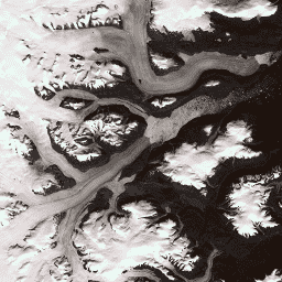
Este conjunto de datos proporciona un mosaico de imágenes completo con una resolución de 15 m de la capa de hielo de Groenlandia, derivado de las imágenes de Landsat 7 ETM+ y RADARSAT-1 SAR de los años 1999 a 2002. Los métodos incluyen una combinación de enmascaramiento de nubes de imágenes, nitidez panorámica, muestreo y cambio de tamaño de imágenes, y correlación de imágenes. Consulta Howat, 2014 para obtener más información sobre los métodos de procesamiento.
Nota
- Los usuarios de imágenes de mosaico de GIMP DEM o GIMP 2000 pueden encontrar útil enmascarar las áreas fuera de la costa de Groenlandia con la imagen de máscara oceánica correspondiente de 15 m del proyecto de mapeo de hielo de Groenlandia (GIMP), máscara de clasificación de hielo terrestre y océano,
- Los datos de SAR se distribuyen con una resolución de 20 m. Los datos se aumentaron con interpolación bilineal a 15 m para que coincidieran con la resolución de la banda 8 de Landsat.
Bandas
Bandas
Tamaño de píxel: Varía
| Nombre | Tamaño de los píxeles | Longitud de onda | Descripción |
|---|---|---|---|
B1 |
15 metros | 0.45 a 0.52 µm | Landsat 7 ETM+, azul |
B2 |
15 metros | 0.52 a 0.60 µm | Landsat 7 ETM+, banda verde |
B3 |
15 metros | 0.63 a 0.69 μm | Banda roja del ETM+ de Landsat 7 |
B4 |
15 metros | 0.77 a 0.90 µm | Landsat 7 ETM+, infrarrojo cercano |
B5 |
30 metros | 1.55 a 1.75 μm | Landsat 7 ETM+, infrarrojo de onda corta 1 |
B6_low_gain |
30 metros | 10.40 a 12.50 μm | Landsat 7 ETM+, infrarrojo térmico 1 de baja ganancia. Esta banda tiene un rango dinámico expandido y una resolución radiométrica (sensibilidad) más baja, con menos saturación en valores altos del número digital (DN). Se realizó un nuevo muestreo de 60 m a 30 m. |
B6_high_gain |
30 metros | 10.40 a 12.50 μm | Infrarrojo térmico 1 de alta ganancia ETM+ de Landsat 7. Esta banda tiene una mayor resolución radiométrica (sensibilidad), aunque tiene un rango dinámico más restringido. Se realizó un nuevo muestreo de 60 m a 30 m. |
B7 |
30 metros | 2.08 a 2.35 µm | Landsat 7 ETM+, infrarrojo de onda corta 2 |
B8 |
15 metros | 0.52 a 0.90 µm | Pancromática del ETM+ de Landsat 7 |
B8_radarsat |
15 metros | Ninguno | Imágenes de amplitud del radar de apertura sintética del RADARSAT-1 |
Condiciones de Uso
Condiciones de Uso
Como condición para usar estos datos, debes citar el uso de este conjunto de datos con la cita proporcionada.
Citas
Howat, I.M., A. Negrete, B.E. Smith, 2014, The Greenland Ice Mapping Project (GIMP) land classification and surface elevation datasets, The Cryosphere, 8, 1509-1518, doi:10.5194/tc-8-1509-2014 pdf del artículo
DOI
Explora con Earth Engine
Editor de código (JavaScript)
var dataset = ee.Image('OSU/GIMP/2000_IMAGERY_MOSAIC');
var greenlandImage = dataset.select(['B3', 'B2', 'B1']);
var visParams = {
  min: 0.0,
  max: 255.0,
};
Map.setCenter(-29.1605, 70.4, 9);
Map.addLayer(greenlandImage, visParams, 'Greenland Pansharpened Image');