- Dataset Availability
- 2024-08-01T00:00:00Z–2026-07-11T00:31:25Z
- Dataset Producer
- NASA JPL
- Tags
Description
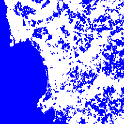
This dataset contains Level-3 Dynamic OPERA surface water extent from Sentinel-1 (DSWX-S1). DSWx-S1 provides near-global geographical mapping of surface water extent over land at a spatial resolution of 30 meters over the Military Grid reference System (MGRS) grid system, with a temporal revisit frequency between 6-12 days. Using Sentinel-1 radar observations, DSWx-S1 maps open inland water bodies greater than 3 hectares and 200 meters in width, irrespective of cloud conditions and daylight illumination that often pose challenges to optical sensors. Forward production of the DSWx-S1 data record began in Sept 2024.
Documentation:
Bands
Bands
Pixel size: 30 meters (all bands)
| Name | Pixel Size | Description |
|---|---|---|
WTR_Water_classification |
30 meters | Masked interpreted water classification layer. This represents pixel-wise classification into one of three water classes (not water, open water and inundated vegetation), masks (HAND mask and layover/shadow mask), or no data classes. |
BWTR_Binary_water |
30 meters | The binary water map is derived from the WTR layer as a union of water classes (open water and inundated vegetation) into a binary map indicating areas with and without water. Invalid data classes (HAND masked, layover/shadow masked and fill value) are also provided to indicate areas in which the binary classification does not provide water/not water classification. |
CONF_Confidence |
30 meters | A representation of the confidence associated with the WTR classification that is based on DIAG results. For example, the Open water class of the WTR layer is split into two classes: High Confidence and Moderate Confidence. Additionally, this layer includes areas characterized by low backscattering that are not water: Low-backscattering not water and land cover masked. Detailed explanations of these classifications are outlined in the DSWx-S1 ATBD. Similar to the WTR and BWTR layers, the Confidence (CONF) layer also marks pixels where water detection is challenging or unfeasible due to factors like layover/shadow effects, no-data areas, and regions where water presence is hydrologically unrealistic (identified by HAND mask). |
DIAG_diagnostic |
30 meters | A metric of Fuzzy values is computed using ancillary data, including HAND, terrain slope angle, reference water, and RTC-S1 backscattering, applying specific thresholds. These values fall within a range of 0 to 100, where a higher value signifies a greater likelihood of the presence of open water. |
WTR_Water_classification Class Table
| Value | Color | Description |
|---|---|---|
| 0 | #ffffff | Not water - an area with valid data that is not open water (class 1), inundated vegetation (class 3), height above nearest drainage masked (class 250), or layover/shadow masked (class 251). Masking can result in “not water” (class 0) where land cover masking is applied. |
| 1 | #0000ff | Open water - an area that is entirely water and unobstructed to the sensor, including obstructions by vegetation, terrain, and buildings. |
| 3 | #66c2a5 | Inundated vegetation - an area that is considered inundated, extracted from the high value in dual polarization ratio and the wetland class in land cover map. |
| 250 | #d3d3d3 | Height Above Nearest Drainage (HAND) masked - an area where topographic height is higher than the HAND threshold. |
| 251 | #a9a9a9 | Layover/shadow masked - an area identified as layover or shadow computed from the geometry of the digital elevation model and sensor. The area is directly copied from input burst RTC-S1 products. |
| 254 | #000080 | Ocean masked - an area identified as ocean using a shoreline database with an added margin. |
BWTR_Binary_water Class Table
| Value | Color | Description |
|---|---|---|
| 0 | #ffffff | Not water - an area with valid data that is not water (class 1) and not HAND masked (class 252), layover or shadow (class 253) |
| 1 | #0000ff | water - an area classified as "open water" or "inundated vegetation" (see WTR layer). |
| 250 | #d3d3d3 | Height Above Nearest Drainage (HAND) masked - an area where topographic height is higher than the HAND threshold. |
| 251 | #a9a9a9 | Layover/shadow masked - an area identified as layover or shadow computed from the geometry of the digital elevation model and sensor. The area is directly copied from input burst RTC-S1 products. |
CONF_Confidence Class Table
| Value | Color | Description |
|---|---|---|
| 0 | #ffffff | Not water - an area with valid data that is not open water high-confidence (class 1), open water moderate-confidence (class 2), inundated vegetation (class 3), low-backscattering not water estimated from bimodality test(class 5), low-backscattering not water estimated from ancillary mask (class 6), height above nearest drainage masked (class 250), or layover/shadow masked (class 251). |
| 1 | #0000ff | Open water high-confidence - an area that is entirely water and unobstructed to the sensor, including obstructions by vegetation, terrain, and buildings and is not overlapping with wetland areas in the Input land cover map. |
| 2 | #0088ff | Open water moderate-confidence - an area with higher backscattering than initial thresholds, considered as water due to the unimodal distribution with surrounding water pixels and not overlapping with wetland areas in the Input land cover map. |
| 5 | #66c2a5 | Potential inundated vegetation - an area with a high dual polarization ratio that is not overlapping with wetland areas in the input land cover map. |
| 6 | #e0e0e0 | Low-backscattering not water (bimodality test) - an area with lower backscattering than thresholds, not considered water based on the bimodality test, and not overlapping with wetland areas in the input land cover map. |
| 7 | #cccccc | Low-backscattering not water (ancillary mask) - an area with lower backscattering than the threshold, considered not water based on historical records of water extents, backscattering level, slope angle, and land cover classes, and not overlapping with wetland areas in the input land cover map. |
| 30 | #aaaaaa | Not water - an area with valid data that is not open water high-confidence (class 31), open water moderate-confidence (class 32), inundated vegetation (class 35), low-backscattering not water estimated from bimodality test(class 36), lowbackscattering not water estimated from ancillary mask (class 37), height above nearest drainage masked (class 250), or layover/shadow masked (class 251) and overlap with wetland areas in the Input land cover map. |
| 31 | #0040ff | Open water high-confidence - an area entirely composed of water, unobstructed to the sensor by vegetation, terrain, or buildings, and overlapping with wetland areas in the input land cover map. |
| 32 | #4080ff | Open water moderate-confidence - an area with higher backscattering than initial thresholds, considered water due to its unimodal distribution with surrounding water pixels, and overlapping with wetland areas in the input land cover map |
| 35 | #20b2aa | Inundated vegetation - an area considered inundated due to a high value in dual polarization ratio and overlapping with wetland areas in the input land cover map. |
| 36 | #bbbbbb | Low-backscattering not water (bimodality test) - an area with lower backscattering than thresholds, not considered water based on the bimodality test, and overlapping with wetland areas in the input land cover map. |
| 37 | #888888 | Low-backscattering not water (ancillary mask) - an area with lower backscattering than the threshold, considered not water based on historical records of water extents, backscattering level, slope angle, and land cover classes, and overlapping with wetland areas in the input land cover map. |
| 250 | #d3d3d3 | Height Above Nearest Drainage (HAND) masked - an area where topographic height is higher than the HAND threshold. |
| 251 | #a9a9a9 | Layover/shadow masked - an area identified as layover or shadow computed from the geometry of the digital elevation model and sensor. The area is directly copied from input burst RTC products. |
DIAG_diagnostic Class Table
| Value | Color | Description |
|---|---|---|
| 0 | #bb0000 | Fuzzy value associated with the WTR classification that is computed from backscattering intensity, reference water, slope angle, and HAND values. (Values 0 to 100) |
| 252 | #d3d3d3 | Height Above Nearest Drainage (HAND) masked - an area where topographic height is higher than the HAND threshold. |
| 253 | #a9a9a9 | Layover/shadow masked - an area identified as layover or shadow computed from the geometry of the digital elevation model and sensor. The area is directly copied from input burst RTC-S1 products. |
Image Properties
Image Properties
| Name | Type | Description |
|---|---|---|
| DSWX_PRODUCT_VERSION | STRING | The DSWx-S1 product version |
| LAYOVER_SHADOW_COVERAGE | DOUBLE | The percentage of layover and shadow in the DSWx-S1 product based on OPERA RTC-S1 product. |
| POLARIZATION | STRING | Polarizations (e.g. VV, VH) |
| PROCESSING_DATETIME | STRING | DSWx-S1 product processing date. Format: YYYY-MM-DDTHH:MM:SSZ. |
| RTC_ORBIT_PASS_DIRECTION | STRING | Orbit direction (e.g. Ascending or Descending). |
| RTC_PRODUCT_VERSION | STRING | The version of OPERA RTC algorithm used for RTC products. |
| SENSOR | STRING | Name of the sensor instrument (e.g., "IW") |
| SPACECRAFT_NAME | STRING | Name of the sensor platform (e.g., Sentinel-1A/B) |
| SPATIAL_COVERAGE | DOUBLE | The area percentage of the tile with data. |
Terms of Use
Terms of Use
This dataset is openly shared, without restriction, in accordance with the EOSDIS Data Use and Citation Guidance
Citations
OPERA . 2024. OPERA Dynamic Surface Water Extent from Sentinel-1 product (Version 1). Ver. 1.0. PO.DAAC, CA, USA. Dataset accessed [YYYY-MM-DD] at https://doi.org/10.5067/OPDSWS1-L3V1
DOIs
Explore with Earth Engine
Code Editor (JavaScript)
Map.setCenter(13.1921, 55.7069, 10);
var dswx_s1_collection = ee.ImageCollection('OPERA/DSWX/L3_V1/S1')
                 .filterDate('2025-03-01', '2025-10-01');

// Mask out values >= 252 before calculating the mode we don't
// want to have clouds or snow/ice be included.
var masked_collection = dswx_s1_collection.map(function(image) {
  var wtr = image.select('WTR_Water_classification');
  return wtr.updateMask(wtr.lt(252));
});

var dswx_s1 = masked_collection
  .reduce(ee.Reducer.max())
  .rename('WTR_Water_classification');

var wtr_class_values = [
  0,    // Not water
  1,    // Open water
  2,    //Partial surface water
  252,  // Snow/ice
  253,  // Cloud/cloud shadow
  254   // Ocean masked
];

var wtr_palette = [
  'ffffff',  // Not water
  '0000ff',  // Open water
  '0088ff',  // Partial surface water
  'f2f2f2',  // Snow/ice
  'dfdfdf',  // Cloud/cloud shadow
  'da00ff',  // Ocean masked
];

// Select the water classification band and remap to make have palette vis.
var wtr_band = dswx_s1.select('WTR_Water_classification');
var to = [0, 1, 2, 3, 4, 5];
var wtr_remapped = wtr_band.remap(wtr_class_values, to);

Map.addLayer(
    wtr_remapped,
    {min: 0, max: 5, palette: wtr_palette}, 'Water Classification (Remapped)');