VNP09GA: VIIRS Surface Reflectance Daily 500m and 1km [deprecated]
Tetap teratur dengan koleksi
Simpan dan kategorikan konten berdasarkan preferensi Anda.
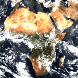
Produk Visible Infrared Imaging Radiometer Suite (VIIRS) daily surface reflectance (VNP09GA) memberikan estimasi reflektivitas permukaan lahan dari sensor VIIRS Suomi National Polar-Orbiting Partnership (S-NPP). Data disediakan untuk tiga band gambar (I1, I2, I3) pada resolusi nominal 500 meter (~463 meter) dan sembilan band resolusi sedang (M1, M2, M3, M4, M5, M7, M8, M10, M11) pada resolusi nominal 1 kilometer (~926 meter). Set data 500 meter dan 1 kilometer diperoleh melalui pengambilan sampel ulang resolusi VIIRS 375 meter dan 750 meter asli, masing-masing, dalam produk input L2. Rentang ini dikoreksi untuk kondisi atmosfer guna memberikan perkiraan pantulan spektral permukaan sebagaimana diukur di permukaan tanah.
Data diagregasikan secara temporal di setiap 16 kemungkinan lintasan per hari. Jika ada beberapa pengamatan untuk setiap hari, hanya pengamatan pertama
dengan kualitas tertinggi yang disertakan.
1: Input AM tidak valid di atas daratan atau di atas lautan
Bit 7: Data input PW tidak ada
0: Tidak
1: Ya
QF5
1.000 meter
Tidak ada
Flag kualitas 5
Bitmask untuk QF5
Bit 0: Data input ozon tidak ada
0: Tidak
1: Ya
Bit 1: Data input tekanan permukaan tidak ada
0: Tidak
1: Ya
Bit 2: Data refleksi permukaan M1 berkualitas secara keseluruhan
0: Baik
1: Buruk
Bit 3: Data refleksi permukaan M2 kualitas keseluruhan
0: Baik
1: Buruk
Bit 4: Data refleksi permukaan M3 dengan kualitas keseluruhan
0: Baik
1: Buruk
Bit 5: Data refleksi permukaan M4 dengan kualitas keseluruhan
0: Baik
1: Buruk
Bit 6: Data refleksi permukaan M5 dengan kualitas keseluruhan
0: Baik
1: Buruk
Bit 7: Data refleksi permukaan M7 dengan kualitas keseluruhan
0: Baik
1: Buruk
QF6
1.000 meter
Tidak ada
Flag kualitas 6
Bitmask untuk QF6
Bit 0: Data refleksi permukaan M8 dengan kualitas keseluruhan
0: Baik
1: Buruk
Bit 1: Data refleksi permukaan M10 dengan kualitas keseluruhan
0: Baik
1: Buruk
Bit 2: Data refleksi permukaan M11 dengan kualitas keseluruhan
0: Baik
1: Buruk
Bit 3: Kualitas keseluruhan data refleksi permukaan I1
0: Baik
1: Buruk
Bit 4: Data refleksi permukaan I2 dengan kualitas keseluruhan
0: Baik
1: Buruk
Bit 5: Data refleksi permukaan I3 dengan kualitas keseluruhan
0: Baik
1: Buruk
QF7
1.000 meter
Tidak ada
Flag kualitas 7
Bitmask untuk QF7
Bit 0: Salju ada
0: Tidak
1: Ya
Bit 1: Berdekatan dengan awan
0: Tidak
1: Ya
Bit 2-3: Jumlah aerosol
0: Klimatologi
1: Rendah
2: Rata-rata
3: Tinggi
Bit 4: Flag cirrus tipis
0: Tidak
1: Ya
Persyaratan Penggunaan
Persyaratan Penggunaan
Data NASA LP DAAC dapat diakses secara bebas; namun, saat penulis memublikasikan data ini atau karya berdasarkan data tersebut, penulis diminta untuk mengutip set data dalam teks publikasi dan menyertakan referensi ke set data tersebut dalam daftar referensi.
Produk reflektivitas permukaan harian Visible Infrared Imaging Radiometer Suite (VIIRS) (VNP09GA) memberikan perkiraan reflektivitas permukaan lahan dari sensor VIIRS Suomi National Polar-Orbiting Partnership (S-NPP). Data disediakan untuk tiga band gambar (I1, I2, I3) pada resolusi nominal 500 meter (~463 meter) dan sembilan band resolusi sedang (M1, …
[[["Mudah dipahami","easyToUnderstand","thumb-up"],["Memecahkan masalah saya","solvedMyProblem","thumb-up"],["Lainnya","otherUp","thumb-up"]],[["Informasi yang saya butuhkan tidak ada","missingTheInformationINeed","thumb-down"],["Terlalu rumit/langkahnya terlalu banyak","tooComplicatedTooManySteps","thumb-down"],["Sudah usang","outOfDate","thumb-down"],["Masalah terjemahan","translationIssue","thumb-down"],["Masalah kode / contoh","samplesCodeIssue","thumb-down"],["Lainnya","otherDown","thumb-down"]],[],[],["This dataset provides daily land surface reflectance estimates from the Suomi National Polar-Orbiting Partnership (S-NPP) VIIRS sensor, spanning January 19, 2012, to June 16, 2024. It includes three imagery bands (I1, I2, I3) at 500-meter resolution and nine bands (M1-M11) at 1-kilometer resolution. Data is corrected for atmospheric conditions, and is aggregated from up to 16 daily passes. Only the first of the highest-quality daily observations is included. Quality assessment and user guides are available, and the data is freely accessible with citation required.\n"]]