- Доступность набора данных
- 2010-01-13T12:00:00Z–2020-12-31T12:00:00Z
- Производитель наборов данных
- Космический центр космических полетов НАСА
- Каденция
- 3 дня
- Теги
- геофизические
Описание
Глобальные данные NASA-USDA о влажности почвы и набор данных NASA-USDA SMAP о влажности почвы предоставляют информацию о влажности почвы по всему миру с пространственным разрешением 0,25°x0,25°. Эти наборы данных включают в себя данные о влажности поверхностного и подповерхностного слоев почвы (мм), профиле влажности почвы (%) и аномалиях влажности поверхностного и подповерхностного слоев почвы. Аномалии влажности почвы являются безразмерными и представляют собой стандартизированные аномалии, рассчитанные с использованием 31-дневного скользящего окна. Значения около 0 указывают на типичные условия влажности, в то время как очень положительные и очень отрицательные значения указывают на экстремальное увлажнение (условия влажности почвы выше среднего) и высыхание (условия влажности почвы ниже среднего) соответственно.
Этот набор данных создан путем интеграции спутниковых данных о влажности почвы и солености океана (SMOS) уровня 2 в модифицированную двухслойную модель Палмера с использованием одномерного ансамблевого фильтра Калмана (EnKF) для ассимиляции данных. Ассимиляция данных о влажности почвы SMOS помогла улучшить прогнозы влажности почвы, основанные на модели, особенно в регионах с недостаточным количеством измерительных приборов (например, Южная Африка, Ближний Восток), где отсутствуют качественные данные об осадках.
Данный набор данных был разработан Лабораторией гидрологических наук (HSL) в Центре космических полетов имени Годдарда НАСА в сотрудничестве с Службой зарубежного сельскохозяйственного производства Министерства сельского хозяйства США и Лабораторией гидрологии и дистанционного зондирования Министерства сельского хозяйства США.
Группы
Группы
Размер пикселя: 27830 метров (все диапазоны)
| Имя | Единицы | Мин | Макс | Размер пикселя | Описание |
|---|---|---|---|---|---|
ssm | мм | 0* | 25.39* | 27830 метров | Влажность поверхностного слоя почвы |
susm | мм | 0* | 274.6* | 27830 метров | Влажность подповерхностного слоя почвы |
smp | Дробь | 0* | 1* | 27830 метров | Профиль влажности почвы |
ssma | Безразмерная | -4* | 4* | 27830 метров | Аномалия влажности поверхностного слоя почвы |
susma | Безразмерная | -4* | 4* | 27830 метров | Аномалия влажности подповерхностного слоя почвы |
Условия эксплуатации
Условия эксплуатации
Данный набор данных находится в общественном достоянии и доступен без ограничений на использование и распространение. Дополнительную информацию см. в Политике НАСА в отношении данных и информации о науках о Земле .
Цитаты
Болтен, Дж., У. Т. Кроу, С. Чжан, Т. Дж. Джексон и К. А. Рейнольдс (2010). Оценка полезности дистанционного зондирования влажности почвы для оперативного мониторинга сельскохозяйственной засухи, IEEE Transactions on Geoscience and Remote Sensing , 3(1): 57-66. doi:10.1109/JSTARS.2009.2037163 Google Scholar
Болтен, Дж., и У. Т. Кроу (2012). Улучшенное прогнозирование квазиглобальных условий растительности с использованием данных дистанционного зондирования влажности поверхностного слоя почвы, Geophysical Research Letters , 39: (L19406). doi:10.1029/2012GL053470 Google Scholar
IE Mladenova, JD Bolten, WT Crow, MC Anderson, CR Hain, DM Johnson, R. Mueller (2017). Intercomparison of Soil Moisture, Evaporative Stress, and Vegetation Indices for Estimating Corn and Soybean Yields Over the US, IEEE Journal of Selected Topics in Applied Earth Observations and Remote Sensing , 10(4): 1328-1343, doi:10.1109/JSTARS.2016.2639338
Сазиб, Н., И.Е. Младенова, Дж.Д. Болтен (2018). Использование Google Earth Engine для оценки засухи с помощью глобальных данных о влажности почвы. Дистанционное зондирование , 10(8), с. 1265. doi:10.3390/rs10081265 Google Scholar
Керр, Й. Х., и Д. Левин (2008). Предисловие к специальному выпуску, посвященному миссии «Влажность почвы и соленость океана» (SMOS), IEEE Transactions on Geoscience and Remote Sensing , 46(3): 583-585. doi:10.1109/TGRS.2008.917807 Google Scholar
DOI
Исследуйте мир с помощью Earth Engine.
Редактор кода (JavaScript)
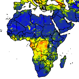
var dataset = ee.ImageCollection('NASA_USDA/HSL/soil_moisture')
                  .filter(ee.Filter.date('2017-04-01', '2017-04-30'));
var soilMoisture = dataset.select('ssm');
var soilMoistureVis = {
  min: 0.0,
  max: 28.0,
  palette: ['0300ff', '418504', 'efff07', 'efff07', 'ff0303'],
};
Map.setCenter(-6.746, 15.529, 2);
Map.addLayer(soilMoisture, soilMoistureVis, 'Soil Moisture');