Page Summary
-
This dataset provides global surface and subsurface soil moisture data at 0.25°x0.25° spatial resolution, including soil moisture profile and anomalies.
-
The dataset was generated by integrating satellite-derived Soil Moisture Ocean Salinity (SMOS) observations into a modified two-layer Palmer model using a 1-D Ensemble Kalman Filter (EnKF) data assimilation approach.
-
The data is available from 2010-01-13 to 2020-12-31 with a 3-day cadence.
-
This dataset has been superseded by NASA/SMAP/SPL4SMGP/007.
-
The dataset is in the public domain and available without restriction on use and distribution.
- Dataset Availability
- 2010-01-13T12:00:00Z–2020-12-31T12:00:00Z
- Dataset Producer
- NASA GSFC
- Cadence
- 3 Days
- Tags
Description
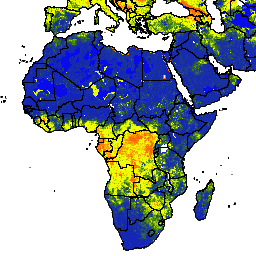
The NASA-USDA Global soil moisture and the NASA-USDA SMAP Global soil moisture dataset provide soil moisture information across the globe at 0.25°x0.25° spatial resolution. These datasets include surface and subsurface soil moisture (mm), soil moisture profile (%), and surface and subsurface soil moisture anomalies. Soil moisture anomalies are unitless and represent standardized anomalies computed using a 31-days moving window. Values around 0 indicate typical moisture conditions, while very positive and very negative values indicate extreme wetting (soil moisture conditions are above average) and drying (soil moisture conditions are below average), respectively.
This dataset is generated by integrating satellite-derived Soil Moisture Ocean Salinity (SMOS) Level 2 soil moisture observations into the modified two-layer Palmer model using a 1-D Ensemble Kalman Filter (EnKF) data assimilation approach. The assimilation of the SMOS soil moisture observations helped improve the model-based soil moisture predictions particularly over poorly instrumented areas (e.g., Southern African, Middle East) of the world that lack good quality precipitation data.
This dataset was developed by the Hydrological Science Laboratory (HSL) at NASA's Goddard Space Flight Center in cooperation with USDA Foreign Agricultural Services and USDA Hydrology and Remote Sensing Lab.
Bands
Bands
Pixel size: 27830 meters (all bands)
| Name | Units | Min | Max | Pixel Size | Description |
|---|---|---|---|---|---|
ssm |
mm | 0* | 25.39* | 27830 meters | Surface soil moisture |
susm |
mm | 0* | 274.6* | 27830 meters | Subsurface soil moisture |
smp |
Fraction | 0* | 1* | 27830 meters | Soil moisture profile |
ssma |
Dimensionless | -4* | 4* | 27830 meters | Surface soil moisture anomaly |
susma |
Dimensionless | -4* | 4* | 27830 meters | Subsurface soil moisture anomaly |
Terms of Use
Terms of Use
This dataset is in the public domain and is available without restriction on use and distribution. See NASA's Earth Science Data & Information Policy for additional information.
Citations
Bolten, J., W.T. Crow, X. Zhan, T.J. Jackson, and C.A. Reynolds (2010). Evaluating the Utility of Remotely Sensed Soil Moisture Retrievals for Operational Agricultural Drought Monitoring, IEEE Transactions on Geoscience and Remote Sensing, 3(1): 57-66. doi:10.1109/JSTARS.2009.2037163 Google Scholar
Bolten, J., and W. T. Crow (2012). Improved prediction of quasi-global vegetation conditions using remotely-sensed surface soil moisture, Geophysical Research Letters, 39: (L19406). doi:10.1029/2012GL053470 Google Scholar
I. E. Mladenova, J.D. Bolten, W.T. Crow, M.C. Anderson, C.R. Hain, D.M. Johnson, R. Mueller (2017). Intercomparison of Soil Moisture, Evaporative Stress, and Vegetation Indices for Estimating Corn and Soybean Yields Over the U.S., IEEE Journal of Selected Topics in Applied Earth Observations and Remote Sensing, 10(4): 1328-1343, doi:10.1109/JSTARS.2016.2639338
Sazib, N., I. E. Mladenova, J.D. Bolten (2018). Leveraging the Google Earth Engine for Drought Assessment Using Global Soil Moisture Data. Remote Sensing, 10(8), p.1265. doi:10.3390/rs10081265 Google Scholar
Kerr, Y. H., and D. Levine (2008). Forward to the special issue on the Soil Moisture and Ocean Salinity (SMOS) mission, IEEE Transactions on Geoscience and Remote Sensing, 46(3): 583-585. doi:10.1109/TGRS.2008.917807 Google Scholar
DOIs
Explore with Earth Engine
Code Editor (JavaScript)
var dataset = ee.ImageCollection('NASA_USDA/HSL/soil_moisture')
                  .filter(ee.Filter.date('2017-04-01', '2017-04-30'));
var soilMoisture = dataset.select('ssm');
var soilMoistureVis = {
  min: 0.0,
  max: 28.0,
  palette: ['0300ff', '418504', 'efff07', 'efff07', 'ff0303'],
};
Map.setCenter(-6.746, 15.529, 2);
Map.addLayer(soilMoisture, soilMoistureVis, 'Soil Moisture');