This dataset provides classes of global forests delineated by
status/condition in 2020 at approximately 30m resolution. The data support
generating Tier 1 estimates for Aboveground dry woody Biomass Density (AGBD)
in natural forests in the 2019 Refinement to the 2006 IPCC Guidelines for
National Greenhouse Gas Inventories. 
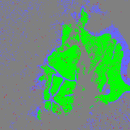
Forest classes include primary, young
secondary (<=20 years), and old secondary forests (>20 years).
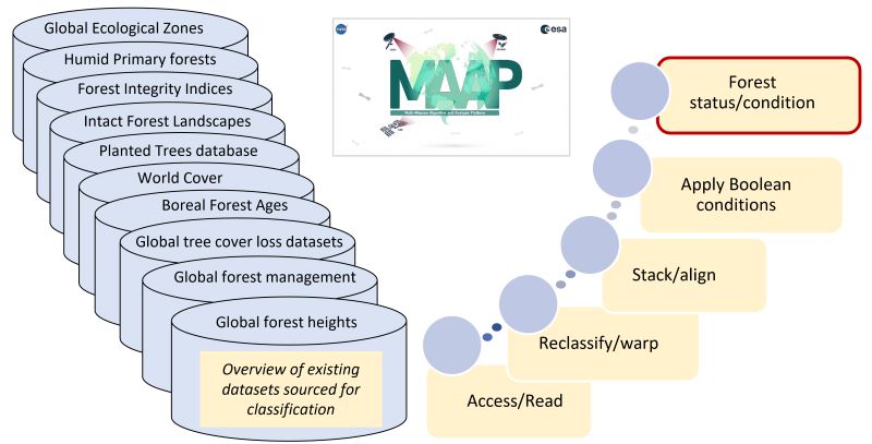
 Classification
was based on a Boolean combination of a suite of existing Earth Observation
(EO) products of forest tree cover, height, age, and land use classification
layers representing years 2000 to 2020. This forest status/condition
classification prioritizes the reduction of potential errors of commission in
the delineations by minimizing the inclusion of ambiguous pixels. Hence, it
provides a conservative estimate of global forest area, identifying
approximately 3.26 billion ha of forests worldwide.
Quality Assessment
These data provide a comprehensive compilation of the latest published
datasets on forest conditions, but the nonexistence of any independent sample
of global data that would enable the validation of these delineations is a
constraint. Hence, the global forest status/condition classification has not
been validated.
Data Acquisition, Materials, and Methods
The forest status/condition classification is created by conducting a
Boolean analysis of a suite of existing datasets (see Table 1,
Hunka et al., 2024),
including satellite-derived forest tree cover, height, age,
and land use classification layers. In this approach, layers that
identify a potential forest status/condition class (e.g. primary forests) are
merged, and layers that identify sources of disagreement (e.g. presence of
plantations or deforestation detected in the delineated primary forests) are
used to remove areas of potential commission errors.
The primary forest class is established using datasets identifying
intact/primary forests, with a high forest integrity index, the presence of
tree cover and forest heights ≥5 m and no known forest loss events, planted
forests or plantations.
The young secondary forest class captures pixels that had changes in
forest height or cover between 2000 and 2020, excluding planted forests and
plantations. These forests were identified by heights ≥5 m in 2020 and either
(a) heights <5 m in 2000 or (b) heights ≥5 m in 2000 but having experienced
tree cover loss after 2000.
The old secondary forest class captures the remainder of pixels with
forests after excluding the primary and young secondary forest classes. These
pixels had forest heights ≥5 m in both 2000 and 2020 with no tree cover loss
nor forest disturbances detected after 2000, nor any planted forests or
plantations.
Hunka, N., L. Duncanson, J. Armston, R.O. Dubayah, S.P. Healey, M.
Santoro, P. May, A. Araza, C. Bourgain, P.M. Montesano, C.S. Neigh, H.
Grantham, V. Potapov, S. Turubanova, A. Tyukavina, J. Richter, N. Harris, M.
Urbazaev, A. Pascual, D. Requena Suarez, M. Herold, B. Poulter, S.N. Wilson,
G. Grassi, S. Federici, M.J. Sanz Sanchez, and J. Melo. 2024. Classification
of Global Forests for IPCC Aboveground Biomass Tier 1 Estimates, 2020. ORNL
DAAC, Oak Ridge, Tennessee, USA.
https://doi.org/10.3334/ORNLDAAC/2345
Hunka, N., Duncanson, L., Armston, J. et al. Intergovernmental Panel on Climate Change (IPCC) Tier 1 forest biomass estimates from Earth Observation. Sci Data 11, 1127 (2024). https://doi.org/10.1038/s41597-024-03930-9
doi:10.1038/s41597-024-03930-9
This dataset provides classes of global forests delineated by status/condition in 2020 at approximately 30m resolution. The data support generating Tier 1 estimates for Aboveground dry woody Biomass Density (AGBD) in natural forests in the 2019 Refinement to the 2006 IPCC Guidelines for National Greenhouse Gas Inventories. Forest classes include …
[[["Easy to understand","easyToUnderstand","thumb-up"],["Solved my problem","solvedMyProblem","thumb-up"],["Other","otherUp","thumb-up"]],[["Missing the information I need","missingTheInformationINeed","thumb-down"],["Too complicated / too many steps","tooComplicatedTooManySteps","thumb-down"],["Out of date","outOfDate","thumb-down"],["Samples / code issue","samplesCodeIssue","thumb-down"],["Other","otherDown","thumb-down"]],[],[[["\u003cp\u003eThis dataset provides a 30m resolution global classification of forest types (primary, young secondary, and old secondary) for the year 2020.\u003c/p\u003e\n"],["\u003cp\u003eIt was created using a Boolean analysis of existing Earth Observation products, including forest cover, height, age, and land use.\u003c/p\u003e\n"],["\u003cp\u003eThe data supports generating Tier 1 estimates for Aboveground dry woody Biomass Density (AGBD) as outlined in the 2019 Refinement to the 2006 IPCC Guidelines for National Greenhouse Gas Inventories.\u003c/p\u003e\n"],["\u003cp\u003eThe classification prioritizes reducing errors by minimizing the inclusion of ambiguous pixels, resulting in a conservative estimate of global forest area.\u003c/p\u003e\n"],["\u003cp\u003eAlthough comprehensive, the dataset has not been independently validated due to the lack of a global sample of comparable data.\u003c/p\u003e\n"]]],["This dataset classifies global forests by condition in 2020 at 30m resolution, supporting IPCC Aboveground Biomass Density estimates. Forest classes include primary, young secondary (≤20 years), and old secondary forests (\u003e20 years). The classification uses satellite data on tree cover, height, age, and land use from 2000-2020 to create the classification, which minimizes potential errors. It has not been validated, but is availabe in the public domain and identified 3.26 billion ha of forest.\n"],null,["# Global 2020 Forest Classification for IPCC Aboveground Biomass Tier 1 Estimates, V1\n\nDataset Availability\n: 2020-01-01T00:00:00Z--2020-12-31T00:00:00Z\n\nDataset Provider\n:\n\n\n [NASA ORNL DAAC at Oak Ridge National Laboratory](https://doi.org/10.3334/ORNLDAAC/2345)\n\nTags\n:\n [aboveground](/earth-engine/datasets/tags/aboveground) [biomass](/earth-engine/datasets/tags/biomass) [carbon](/earth-engine/datasets/tags/carbon) [classification](/earth-engine/datasets/tags/classification) [forest](/earth-engine/datasets/tags/forest) [forest-biomass](/earth-engine/datasets/tags/forest-biomass) [ipcc](/earth-engine/datasets/tags/ipcc) [nasa](/earth-engine/datasets/tags/nasa) [primary-forest](/earth-engine/datasets/tags/primary-forest) \nsecondary-forest \n\n#### Description\n\nThis dataset provides classes of global forests delineated by\nstatus/condition in 2020 at approximately 30m resolution. The data support\ngenerating Tier 1 estimates for Aboveground dry woody Biomass Density (AGBD)\nin natural forests in the 2019 Refinement to the 2006 IPCC Guidelines for\nNational Greenhouse Gas Inventories. Forest classes include primary, young\nsecondary (\\\u003c=20 years), and old secondary forests (\\\u003e20 years). Classification\nwas based on a Boolean combination of a suite of existing Earth Observation\n(EO) products of forest tree cover, height, age, and land use classification\nlayers representing years 2000 to 2020. This forest status/condition\nclassification prioritizes the reduction of potential errors of commission in\nthe delineations by minimizing the inclusion of ambiguous pixels. Hence, it\nprovides a conservative estimate of global forest area, identifying\napproximately 3.26 billion ha of forests worldwide.\n\n### Quality Assessment\n\nThese data provide a comprehensive compilation of the latest published\ndatasets on forest conditions, but the nonexistence of any independent sample\nof global data that would enable the validation of these delineations is a\nconstraint. Hence, the global forest status/condition classification has not\nbeen validated.\n\n### Data Acquisition, Materials, and Methods\n\nThe forest status/condition classification is created by conducting a\nBoolean analysis of a suite of existing datasets (see Table 1,\n[Hunka et al., 2024](https://doi.org/10.1038/s41597-024-03930-9)),\nincluding satellite-derived forest tree cover, height, age,\nand land use classification layers. In this approach, layers that\nidentify a potential forest status/condition class (e.g. primary forests) are\nmerged, and layers that identify sources of disagreement (e.g. presence of\nplantations or deforestation detected in the delineated primary forests) are\nused to remove areas of potential commission errors.\n\nThe primary forest class is established using datasets identifying\nintact/primary forests, with a high forest integrity index, the presence of\ntree cover and forest heights ≥5 m and no known forest loss events, planted\nforests or plantations.\n\nThe young secondary forest class captures pixels that had changes in\nforest height or cover between 2000 and 2020, excluding planted forests and\nplantations. These forests were identified by heights ≥5 m in 2020 and either\n(a) heights \\\u003c5 m in 2000 or (b) heights ≥5 m in 2000 but having experienced\ntree cover loss after 2000.\n\nThe old secondary forest class captures the remainder of pixels with\nforests after excluding the primary and young secondary forest classes. These\npixels had forest heights ≥5 m in both 2000 and 2020 with no tree cover loss\nnor forest disturbances detected after 2000, nor any planted forests or\nplantations.\n\n[Schematic of analysis workflow](https://daac.ornl.gov/CMS/guides/CMS_Global_Forest_Age_Fig2.jpg)\n\n### Bands\n\n\n**Pixel Size**\n\n30 meters\n\n**Bands**\n\n| Name | Pixel Size | Description |\n|------------------|------------|-------------|\n| `classification` | meters | Forest Type |\n\n**classification Class Table**\n\n| Value | Color | Description |\n|-------|---------|------------------------|\n| 1 | #00ff00 | Primary Forest |\n| 2 | #ff0000 | Young Secondary Forest |\n| 3 | #6666ff | Old Secondary Forest |\n\n### Terms of Use\n\n**Terms of Use**\n\nThis dataset is in the public domain and is available\nwithout restriction on use and distribution. See [NASA's\nEarth Science Data \\& Information Policy](https://www.earthdata.nasa.gov/engage/open-data-services-and-software/data-and-information-policy)\nfor additional information.\n\n### Citations\n\nCitations:\n\n- Hunka, N., L. Duncanson, J. Armston, R.O. Dubayah, S.P. Healey, M.\n Santoro, P. May, A. Araza, C. Bourgain, P.M. Montesano, C.S. Neigh, H.\n Grantham, V. Potapov, S. Turubanova, A. Tyukavina, J. Richter, N. Harris, M.\n Urbazaev, A. Pascual, D. Requena Suarez, M. Herold, B. Poulter, S.N. Wilson,\n G. Grassi, S. Federici, M.J. Sanz Sanchez, and J. Melo. 2024. Classification\n of Global Forests for IPCC Aboveground Biomass Tier 1 Estimates, 2020. ORNL\n DAAC, Oak Ridge, Tennessee, USA.\n \u003chttps://doi.org/10.3334/ORNLDAAC/2345\u003e\n- Hunka, N., Duncanson, L., Armston, J. et al. Intergovernmental Panel on Climate Change (IPCC) Tier 1 forest biomass estimates from Earth Observation. Sci Data 11, 1127 (2024). https://doi.org/10.1038/s41597-024-03930-9\n [doi:10.1038/s41597-024-03930-9](https://doi.org/10.1038/s41597-024-03930-9)\n\n### DOIs\n\n- \u003chttps://doi.org/10.1038/s41597-024-03930-9\u003e\n- \u003chttps://doi.org/10.3334/ORNLDAAC/2345\u003e\n\n### Explore with Earth Engine\n\n| **Important:** Earth Engine is a platform for petabyte-scale scientific analysis and visualization of geospatial datasets, both for public benefit and for business and government users. Earth Engine is free to use for research, education, and nonprofit use. To get started, please [register for Earth Engine access.](https://console.cloud.google.com/earth-engine)\n\n### Code Editor (JavaScript)\n\n```javascript\nvar dataset = ee.ImageCollection('NASA/ORNL/global_forest_classification_2020/V1');\n\nvar visualization = {\n bands: ['classification'],\n min: 1.0,\n max: 3.0,\n palette: ['00ff00', 'ff0000', '6666ff'],\n};\n\nMap.setCenter(-53, -5, 6);\nMap.addLayer(dataset, visualization, 'Forest Type');\n```\n[Open in Code Editor](https://code.earthengine.google.com/?scriptPath=Examples:Datasets/NASA/NASA_ORNL_global_forest_classification_2020_V1) \n[Global 2020 Forest Classification for IPCC Aboveground Biomass Tier 1 Estimates, V1](/earth-engine/datasets/catalog/NASA_ORNL_global_forest_classification_2020_V1) \nThis dataset provides classes of global forests delineated by status/condition in 2020 at approximately 30m resolution. The data support generating Tier 1 estimates for Aboveground dry woody Biomass Density (AGBD) in natural forests in the 2019 Refinement to the 2006 IPCC Guidelines for National Greenhouse Gas Inventories. Forest classes include ... \nNASA/ORNL/global_forest_classification_2020/V1, aboveground,biomass,carbon,classification,forest,forest-biomass,ipcc,nasa,primary-forest \n2020-01-01T00:00:00Z/2020-12-31T00:00:00Z \n-90 -180 90 180 \nGoogle Earth Engine \nhttps://developers.google.com/earth-engine/datasets\n\n- [https://doi.org/10.3334/ORNLDAAC/2345](https://doi.org/https://doi.org/10.3334/ORNLDAAC/2345)\n- [https://doi.org/10.3334/ORNLDAAC/2345](https://doi.org/https://developers.google.com/earth-engine/datasets/catalog/NASA_ORNL_global_forest_classification_2020_V1)"]]