Page Summary
-
The Daymet V3 dataset provides gridded estimates of daily weather parameters for specific regions including the United States, Mexico, Canada, Hawaii, and Puerto Rico from 1980 to 2019.
-
This dataset has been superseded by the NASA/ORNL/DAYMET_V4 version.
-
It includes daily data for parameters such as daylight duration, precipitation, radiation, snow water equivalent, temperature (max and min), and vapor pressure at a pixel size of 1000 meters.
-
The data is in the public domain and available without restrictions on use and distribution.
- Dataset Availability
- 1980-01-01T00:00:00Z–2019-12-31T00:00:00Z
- Dataset Producer
- NASA ORNL DAAC at Oak Ridge National Laboratory
- Cadence
- 1 Day
- Tags
Description
Daymet V3 provides gridded estimates of daily weather parameters for United States, Mexico, Canada, Hawaii, and Puerto Rico. It is derived from selected meteorological station data and various supporting data sources.
Compared to the previous version, Daymet V3 uses an entirely new suite of inputs including:
NASA SRTM DEM version 2.1.
Land/Water Mask: MODIS 250
MOD44W_v2.NASA_ORNL_Horizon files derived from the SRTM DEM.
Ground station weather inputs from several sources with QA/QC.
Documentation:
Bands
Bands
Pixel size: 1000 meters (all bands)
| Name | Units | Min | Max | Pixel Size | Description |
|---|---|---|---|---|---|
dayl |
seconds | 0* | 86400* | 1000 meters | Duration of the daylight period. Based on the period of the day during which the sun is above a hypothetical flat horizon. |
prcp |
mm | 0* | 200* | 1000 meters | Daily total precipitation, sum of all forms converted to water-equivalent. |
srad |
W/m^2 | 0* | 800* | 1000 meters | Incident shortwave radiation flux density, taken as an average over the daylight period of the day. |
swe |
kg/m^2 | 0* | 1000* | 1000 meters | Snow water equivalent, the amount of water contained within the snowpack. |
tmax |
°C | -50* | 50* | 1000 meters | Daily maximum 2-meter air temperature. |
tmin |
°C | -50* | 50* | 1000 meters | Daily minimum 2-meter air temperature. |
vp |
Pa | 0* | 10000* | 1000 meters | Daily average partial pressure of water vapor. |
Terms of Use
Terms of Use
This dataset is in the public domain and is available without restriction on use and distribution. See NASA's Earth Science Data & Information Policy for additional information.
Citations
Thornton, P.E., M.M. Thornton, B.W. Mayer, Y. Wei, R. Devarakonda, R.S.Vose, and R.B. Cook. {YEAR}. Daymet: Daily Surface Weather Data on a 1-km Grid for North America, Version3. ORNL DAAC, Oak Ridge, Tennessee, USA
Other Citation Details - Thornton, P.E., M.M. Thornton, B.W. Mayer, Y. Wei, R. Devarakonda, R.S. Vose, and R.B. Cook. 2016. Daymet: Daily Surface Weather Data on a 1-km Grid for North America, Version 3. ORNL DAAC, Oak Ridge, Tennessee, USA. doi:10.3334/ORNLDAAC/1328
DOIs
Explore with Earth Engine
Code Editor (JavaScript)
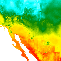
var dataset = ee.ImageCollection('NASA/ORNL/DAYMET_V3')
                  .filter(ee.Filter.date('2017-04-01', '2017-04-30'));
var maximumTemperature = dataset.select('tmax');
var maximumTemperatureVis = {
  min: -40.0,
  max: 30.0,
  palette: ['1621A2', 'white', 'cyan', 'green', 'yellow', 'orange', 'red'],
};
Map.setCenter(-110.21, 35.1, 4);
Map.addLayer(maximumTemperature, maximumTemperatureVis, 'Maximum Temperature');