Page Summary
-
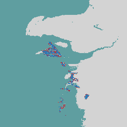
The EMIT dataset provides estimated methane plume complexes (in ppm m) and associated uncertainty data.
-
This data is generated only where methane plume complexes have been identified.
-
The dataset has a daily cadence and covers a date range from August 10, 2022, to October 26, 2024.
-
The data is provided by the NASA Jet Propulsion Laboratory and has no restrictions on use, sale, or redistribution.
- Dataset Availability
- 2022-08-10T00:00:00Z–2024-10-26T17:21:33Z
- Dataset Producer
- NASA Jet Propulsion Laboratory
- Cadence
- 1 Day
- Tags
Description
The EMIT Project is part of the Earth Venture-Instrument (EV-I) Program directed by the Program Director of the NASA Earth Science Division (ESD). EMIT is comprised of a VSWIR Infrared Dyson imaging spectrometer adapted for installation on the International Space Station (ISS). EMIT measures radiance between 380 and 2500 nanometers, with an approximate 7 nm bandpass. Data are collected in a swath that is approximately 75 km wide at the equator, with an approximate ground sampling distance of 60 m. See the provider's NASA EMIT Overview for more details.
EMIT was a particularly useful tool for mapping out greenhouse gases, including methane, carbon dioxide, and water vapor. This is consistent with previous findings from airborne data, but global nature, revisit frequency and wide swath of EMIT provided an unprecedented opportunity to investigate greenhouse gas retrievals.
The EMIT Level 2B Estimated Methane Plume Complexes (EMITL2BCH4PLM) Version 1 data product provides estimated methane plume complexes in parts per million meter (ppm m) along with uncertainty data. The EMITL2BCH4PLM data product will only be generated where methane plume complexes have been identified.
Bands
Bands
Pixel size: 72000 meters (all bands)
| Name | Units | Pixel Size | Description |
|---|---|---|---|
methane_plume_complex |
ppm m | 72000 meters | Estimated Methane plume complex. |
Image Properties
Image Properties
| Name | Type | Description |
|---|---|---|
| global_plume_identifier | STRING | Global Plume Identification Number |
| Concentration_Uncertainty | DOUBLE | Uncertainity in Concentration |
| DAAC_Scene_Names | STRING_LIST | DAAC Scene Names |
| DAAC_Scene_Numbers | STRING_LIST | DAAC Scene Numbers |
| DCID | STRING | Data Collection Identifier |
| Latitude_of_max_concentration | DOUBLE | Latitute with maximum concentration |
| Longitude_of_max_concentration | DOUBLE | Longitude with maximum concentration |
| Max_Plume_Concentration | DOUBLE | Maximum Plume Concentration |
| Orbit | STRING | Unique orbit number |
| Plume_ID | STRING | Unique Plume Identification number |
| Scene_FIDs | STRING_LIST | Scene FIDs |
Terms of Use
Terms of Use
NASA EMIT data and products acquired through the LP DAAC have no restrictions on subsequent use, sale, or redistribution.
Citations
Green, R., Thorpe, A., Brodrick, P., Chadwick, D., Elder, C., Villanueva-Weeks, C., Fahlen, J., Coleman, R., Jensen, D., Olsen-Duvall, W., Lundeen, S., Lopez, A., Thompson, D. (2023). EMIT L2B Estimated Methane Plume Complexes 60 m V001 [Data set]. NASA EOSDIS Land Processes Distributed Active Archive Center. Accessed 2024-03-06 from https://doi.org/10.5067/EMIT/EMITL2BCH4PLM.001
DOIs
Explore with Earth Engine
Code Editor (JavaScript)
var dataset = ee.ImageCollection('NASA/EMIT/L2B/CH4PLM');
var emitEnhancement = dataset.select('methane_plume_complex');
var emitEnhancementVis = {
  min: 0,
  max: 100.0,
  palette: ['d7191c', 'fdae61', 'ffffbf', 'abd9e9', '2c7bb6'],
};
Map.setCenter(53.99, 39.11, 8);
Map.addLayer(
    emitEnhancement, emitEnhancementVis,
    'Emit Enhancement');