- Доступность набора данных
- 2002-07-04T00:00:00Z–2017-03-14T00:00:00Z
- Производитель наборов данных
- НАСА LP DAAC в Центре EROS Геологической службы США
- Каденция
- 16 дней
- Теги
- 16-дневный
Описание
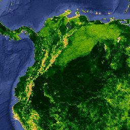
Глобальные индексы растительности MODIS предназначены для обеспечения согласованного пространственного и временного сравнения состояния растительности. Для определения ежедневных индексов растительности MODIS используются синий, красный и ближний инфракрасный коэффициенты отражения с центрами на 469 нанометрах, 645 нанометрах и 858 нанометрах соответственно.
Нормализованный разностный индекс растительности MODIS (NDVI) дополняет продукты NDVI, полученные с помощью усовершенствованного радиометра сверхвысокого разрешения (AVHRR) NOAA, обеспечивая непрерывность для использования в исторических данных временных рядов. MODIS также включает новый улучшенный индекс растительности (EVI), который минимизирует вариации фонового излучения растительного покрова и сохраняет чувствительность в условиях густой растительности. EVI также использует синий диапазон для удаления остаточного атмосферного загрязнения, вызванного дымом и субпиксельными тонкими облаками. Продукты MODIS NDVI и EVI вычисляются на основе атмосферно скорректированных двунаправленных поверхностных отражательных свойств, которые были замаскированы для воды, облаков, тяжелых аэрозолей и облачных теней.
Глобальные данные MYD13A1 предоставляются каждые 16 дней с пространственным разрешением 500 метров в виде сетчатого продукта уровня 3 в синусоидальной проекции. Индексы растительности используются для глобального мониторинга состояния растительности и применяются в продуктах, отображающих земельный покров и изменения земельного покрова. Эти данные могут использоваться в качестве входных данных для моделирования глобальных биогеохимических и гидрологических процессов, а также глобального и регионального климата. Эти данные также могут использоваться для характеристики биофизических свойств и процессов поверхности земли, включая первичную продукцию и преобразование земельного покрова.
Продукты MODIS Vegetation Indices версии 5 прошли 3-ю стадию валидации.
Производство индексов растительности осуществляется поэтапно в период между приобретением компаний Terra и Aqua: Terra начинает с 001-го дня, а Aqua — с 008-го дня.
Пожалуйста, посетите страницу LP DAAC «Цитирование наших данных» для получения информации о цитировании наборов данных LP DAAC.
Условия эксплуатации
Условия эксплуатации
Данные и продукты MODIS, полученные через LP DAAC, не подлежат никаким ограничениям на последующее использование, продажу или распространение.
Исследуйте мир с помощью Earth Engine.
Редактор кода (JavaScript)
var dataset = ee.ImageCollection('MODIS/MYD13A1')
                  .filter(ee.Filter.date('2014-04-01', '2014-06-01'));
var ndvi = dataset.select('NDVI');
var ndviVis = {
  palette: [
    'ffffff', 'ce7e45', 'df923d', 'f1b555', 'fcd163', '99b718', '74a901',
    '66a000', '529400', '3e8601', '207401', '056201', '004c00', '023b01',
    '012e01', '011d01', '011301'
  ],
};
Map.setCenter(-7.03, 31.05, 2);
Map.addLayer(ndvi, ndviVis, 'NDVI');