Page Summary
-
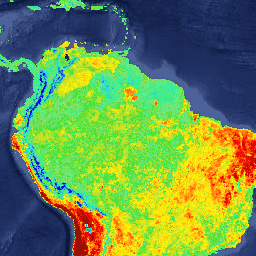
This dataset provides global 8-day Land Surface Temperature (LST) and Emissivity data derived from daily 1-kilometer MODIS MYD11A1 products.
-
The data is available from July 4, 2002, to March 22, 2017, with measurements collected by the Aqua satellite.
-
The dataset includes various layers for both daytime and nighttime observations, such as LST, quality control assessments, and view angles.
-
Quality control flags and clear sky flags are included to assess the reliability and conditions of the data.
-
This Version-5 dataset is considered Validated Stage 2, suitable for use in scientific publications.
- Dataset Availability
- 2002-07-04T00:00:00Z–2017-03-22T00:00:00Z
- Dataset Producer
- NASA LP DAAC at the USGS EROS Center
- Cadence
- 8 Days
- Tags
Description
The level-3 MODIS global Land Surface Temperature (LST) and Emissivity 8-day data are composed from the daily 1-kilometer LST product (MYD11A1) and stored on a 1-km Sinusoidal grid as the average values of clear-sky LSTs during an 8-day period.
MYD11A2 is comprised of the following layers for daytime and nighttime observations:
- LST_Day_1km: Daytime Land Surface Temperatures (K), Scale 0.02
- QC_Day: Daytime Surface Temperature quality control assessments, see QC bit flags
- Day_view_time: Daytime LST Observation Times (Hours), Scale 0.1
- Day_view_angl: Daytime View Zenith Angles (Degrees), Offset -65.0
- LST_Night_1km: Nighttime Land Surface Temperatures (K), Scale 0.02
- QC_Night: Nighttime Surface Temperature quality control assessments, see QC bit flags
- Night_view_time: Nighttime LST Observation Times (Hours), Scale 0.1
- Night_view_angl: Nighttime View Zenith Angles (Degrees), Offset -65.0
- Emis_31: Bands 31 Emissivity, Scale 0.002, Offset 0.49
- Emis_32: Bands 32 Emissivity, Scale 0.002, Offset 0.49
- Clear_sky_days: Clear Sky Day Coverage, see Clear Sky Flags.
- Clear_sky_nights: Clear Sky Nighttime Coverage, see Clear Sky Flags.
QC bit flags:
- Bits 0-1: Mandatory QC Flag
- 00: LST produced, good quality, not necessary to examine detailed QC.
- 01: LST produced, unreliable or unquantifiable quality, recommend examination of more detailed QC.
- 10: LST not produced due to cloud effects.
- 11: LST not produced primarily due to reasons other than clouds.
- Bits 2-3: Data Quality Flag
- 00: Good quality L1B in bands 31 and 32.
- 01: Other quality data.
- 10: TBD
- 11: TBD
- Bits 4-5: Emissivity Error Flag
- 00: Average emissivity error ≤ 0.01
- 01: Average emissivity error ≤ 0.02
- 10: Average emissivity error ≤ 0.04
- 11: Average emissivity error > 0.04
- Bits 6-7: LST Error Flag
- 00: Average LST error ≤ 1 K
- 01: Average LST error ≤ 2 K
- 10: Average LST error ≤ 3 K
- 11: Average LST error > 3 K
Clear Sky Flags:
- Clear Sky Flag for each day (bit 0 is day 1, bit 1 is day 2, etc):
- 0: Day/Night is not clear-sky.
- 1: Day/Night is clear-sky.
Version-5 MODIS/Aqua Land Surface Temperature/Emissivity products are Validated Stage 2, meaning that accuracy has been assessed over a widely distributed set of locations and time periods via several ground-truth and validation efforts. Although there may be later improved versions, these data are ready for use in scientific publications.
Please visit LP DAAC 'Citing Our Data' page for information on citing LP DAAC datasets.
Terms of Use
Terms of Use
MODIS data and products acquired through the LP DAAC have no restrictions on subsequent use, sale, or redistribution.