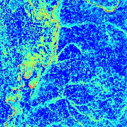
The Normalized Difference Water Index (NDWI) is sensitive
to changes in liquid water content of vegetation canopies. It is
derived from the Near-IR band and a second IR band, ≈1.24μm when
available and the nearest available IR band otherwise. It ranges in
value from -1.0 to 1.0. See
Gao (1996)
for details. This product is generated from the MODIS/MYD09GA surface reflectance composites.
Bands
Bands
Pixel size: 463.313 meters (all bands)
Name
Pixel Size
Description
NDWI
463.313 meters
Normalized Difference Water Index
Terms of Use
Terms of Use
MODIS data and products acquired through the LP DAAC have no restrictions on subsequent use, sale, or redistribution.
The Normalized Difference Water Index (NDWI) is sensitive to changes in liquid water content of vegetation canopies. It is derived from the Near-IR band and a second IR band, ≈1.24μm when available and the nearest available IR band otherwise. It ranges in value from -1.0 to 1.0. See Gao (1996) …
[[["Easy to understand","easyToUnderstand","thumb-up"],["Solved my problem","solvedMyProblem","thumb-up"],["Other","otherUp","thumb-up"]],[["Missing the information I need","missingTheInformationINeed","thumb-down"],["Too complicated / too many steps","tooComplicatedTooManySteps","thumb-down"],["Out of date","outOfDate","thumb-down"],["Samples / code issue","samplesCodeIssue","thumb-down"],["Other","otherDown","thumb-down"]],[],[],["The MODIS/MYD09GA_NDWI dataset, available from 2002-07-04 to 2017-03-30, provides the Normalized Difference Water Index (NDWI) derived from MODIS/MYD09GA surface reflectance composites. The NDWI, with a pixel size of 463.313 meters and a daily cadence, ranges from -1.0 to 1.0, indicating liquid water content in vegetation canopies. The dataset, now superseded, was offered via Google Earth Engine and is free for research, education, and nonprofit purposes. The data has no restrictions on use.\n"]]