MODIS Aqua Daily NDSI [deprecated]
Stay organized with collections
Save and categorize content based on your preferences.
Page Summary
This dataset, providing the Normalized Difference Snow Index (NDSI), has been superseded by MODIS/MYD09GA_006_NDSI.
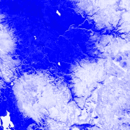
The Normalized Difference Snow Index (NDSI) identifies snow using its reflectance in the visible and mid-IR spectrum, with values ranging from -1.0 to 1.0.
The dataset is available from July 4, 2002, to March 30, 2017, with a daily cadence.
MODIS data and products have no restrictions on subsequent use, sale, or redistribution.
The Normalized Difference Snow Index is used to
identify snow, based on its characteristically higher reflectance in
the visible portion of the spectrum compared to the mid-IR. NDSI is
computed using the Green and Mid-IR bands, and has a range of -1.0 to
1.0. See
Riggs et al. (1994)
for details. This product is generated from the MODIS/MYD09GA surface reflectance composites.
Bands
Bands
Pixel size: 463.313 meters (all bands)
Name
Pixel Size
Description
NDSI
463.313 meters
Normalized Difference Snow Index
Terms of Use
Terms of Use
MODIS data and products acquired through the LP DAAC have no restrictions on subsequent use, sale, or redistribution.
The Normalized Difference Snow Index is used to identify snow, based on its characteristically higher reflectance in the visible portion of the spectrum compared to the mid-IR. NDSI is computed using the Green and Mid-IR bands, and has a range of -1.0 to 1.0. See Riggs et al. (1994) for …
[[["Easy to understand","easyToUnderstand","thumb-up"],["Solved my problem","solvedMyProblem","thumb-up"],["Other","otherUp","thumb-up"]],[["Missing the information I need","missingTheInformationINeed","thumb-down"],["Too complicated / too many steps","tooComplicatedTooManySteps","thumb-down"],["Out of date","outOfDate","thumb-down"],["Samples / code issue","samplesCodeIssue","thumb-down"],["Other","otherDown","thumb-down"]],[],[],["This dataset, now superseded by MODIS/MYD09GA_006_NDSI, provides the Normalized Difference Snow Index (NDSI) derived from MODIS/MYD09GA surface reflectance data, collected between July 4, 2002, and March 30, 2017, with a daily cadence. The NDSI, used to identify snow, is calculated from Green and Mid-IR bands, ranging from -1.0 to 1.0. The data is available via Google Earth Engine and offered at a 463.313-meter pixel size, with unrestricted use.\n"]]