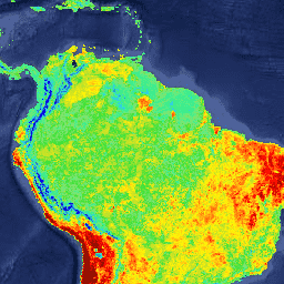
MOD11A2.005 Land Surface Temperature and Emissivity 8-Day Global 1km [deprecated]
Stay organized with collections
Save and categorize content based on your preferences.
Page Summary
This dataset, MODIS/MOD11A2, provides global Land Surface Temperature (LST) and Emissivity data averaged over 8-day periods.
It is derived from the daily 1-kilometer LST product (MOD11A1) and stored on a 1-km Sinusoidal grid.
The dataset includes layers for daytime and nighttime LST, quality control, observation times and angles, emissivity, and clear sky coverage.
This version (Version-5) is considered Validated Stage 2, suitable for scientific publications, but has been superseded by MODIS/061/MOD11A2.
The level-3 MODIS global Land Surface
Temperature (LST) and Emissivity 8-day data are composed from the
daily 1-kilometer LST product (MOD11A1) and stored on a 1-km
Sinusoidal grid as the average values of clear-sky LSTs during an
8-day period.
MOD11A2 is comprised of the following layers for daytime and nighttime
observations:
LST_Day_1km: Daytime Land Surface Temperatures (K), Scale 0.02
QC_Day: Daytime Surface Temperature quality control assessments,
see QC bit flags
Day_view_time: Daytime LST Observation Times (Hours), Scale 0.1
Clear_sky_days: Clear Sky Day Coverage, see Clear Sky Flags.
Clear_sky_nights: Clear Sky Nighttime Coverage, see Clear Sky Flags.
QC bit flags:
Bits 0-1: Mandatory QC Flag
00: LST produced, good quality, not necessary to examine detailed QC.
01: LST produced, unreliable or unquantifiable quality, recommend examination of more detailed QC.
10: LST not produced due to cloud effects.
11: LST not produced primarily due to reasons other than clouds.
Bits 2-3: Data Quality Flag
00: Good quality L1B in bands 31 and 32.
01: Other quality data.
10: TBD
11: TBD
Bits 4-5: Emissivity Error Flag
00: Average emissivity error ≤ 0.01
01: Average emissivity error ≤ 0.02
10: Average emissivity error ≤ 0.04
11: Average emissivity error > 0.04
Bits 6-7: LST Error Flag
00: Average LST error ≤ 1 K
01: Average LST error ≤ 2 K
10: Average LST error ≤ 3 K
11: Average LST error > 3 K
Clear Sky Flags:
Clear Sky Flag for each day (bit 0 is day 1, bit 1 is day 2, etc):
0: Day/Night is not clear-sky.
1: Day/Night is clear-sky.
Version-5 MODIS/Terra Land Surface Temperature/Emissivity products
are Validated Stage 2, meaning that accuracy has been assessed over a
widely distributed set of locations and time periods via several
ground-truth and validation efforts. Although there may be later
improved versions, these data are ready for use in scientific
publications.
The level-3 MODIS global Land Surface Temperature (LST) and Emissivity 8-day data are composed from the daily 1-kilometer LST product (MOD11A1) and stored on a 1-km Sinusoidal grid as the average values of clear-sky LSTs during an 8-day period. MOD11A2 is comprised of the following layers for daytime and nighttime …
[[["Easy to understand","easyToUnderstand","thumb-up"],["Solved my problem","solvedMyProblem","thumb-up"],["Other","otherUp","thumb-up"]],[["Missing the information I need","missingTheInformationINeed","thumb-down"],["Too complicated / too many steps","tooComplicatedTooManySteps","thumb-down"],["Out of date","outOfDate","thumb-down"],["Samples / code issue","samplesCodeIssue","thumb-down"],["Other","otherDown","thumb-down"]],[],[],["The MODIS MOD11A2 dataset provides 8-day global Land Surface Temperature (LST) and Emissivity data from 2000-03-05 to 2017-03-22, derived from daily 1-km LST. It includes daytime and nighttime LSTs, quality control assessments, observation times, and view angles. Emissivity data for bands 31 and 32 is included. Data is gridded at 1-km, with clear sky day/night coverage, accessed via Google Earth Engine using `ee.ImageCollection(\"MODIS/MOD11A2\")`. The dataset has been superseded.\n"]]