Page Summary
-
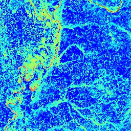
This dataset, providing the Normalized Difference Water Index (NDWI), is now superseded by MODIS/MOD09GA_006_NDWI.
-
The NDWI is derived from Near-IR and another IR band and is sensitive to changes in the liquid water content of vegetation canopies.
-
The dataset is available daily, globally, covers the period from 2000 to 2017, and is provided by Google Earth Engine.
-
MODIS data has no restrictions on subsequent use, sale, or redistribution.
-
Earth Engine is free to use for research, education, and nonprofit purposes, requiring registration for access.
- Dataset Availability
- 2000-02-24T00:00:00Z–2017-03-30T00:00:00Z
- Dataset Producer
- Cadence
- 1 Day
- Tags
Description
The Normalized Difference Water Index (NDWI) is sensitive to changes in liquid water content of vegetation canopies. It is derived from the Near-IR band and a second IR band, ≈1.24μm when available and the nearest available IR band otherwise. It ranges in value from -1.0 to 1.0. See Gao (1996) for details. This product is generated from the MODIS/MOD09GA surface reflectance composites.
Bands
Bands
Pixel size: 463.313 meters (all bands)
| Name | Pixel Size | Description |
|---|---|---|
NDWI |
463.313 meters | Normalized Difference Water Index |
Terms of Use
Terms of Use
MODIS data and products acquired through the LP DAAC have no restrictions on subsequent use, sale, or redistribution.