MODIS Terra Daily BAI [deprecated]
Stay organized with collections
Save and categorize content based on your preferences.
Page Summary
This dataset, providing the Burn Area Index (BAI), is deprecated and has been superseded by MODIS/MOD09GA_006_BAI.
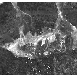
The BAI is generated from Red and Near-IR bands and measures the spectral distance from a reference spectral point to emphasize the charcoal signal in post-fire images.
The dataset is available from 2000-02-24 to 2017-03-30 with a daily cadence.
MODIS data has no restrictions on subsequent use, sale, or redistribution, and Earth Engine is free for research, education, and nonprofit use.
The Burn Area Index (BAI) is generated from the Red and
Near-IR bands, and measures the spectral distance of each pixel from a
reference spectral point (the measured reflectance of charcoal). This
index is intended to emphasize the charcoal signal in post-fire
images. See
Chuvieco et al. (2002)
for details. This product is generated from the MODIS/MOD09GA surface reflectance composites.
Bands
Bands
Pixel size: 463.313 meters (all bands)
Name
Pixel Size
Description
BAI
463.313 meters
Burn Area Index
Terms of Use
Terms of Use
MODIS data and products acquired through the LP DAAC have no restrictions on subsequent use, sale, or redistribution.
The Burn Area Index (BAI) is generated from the Red and Near-IR bands, and measures the spectral distance of each pixel from a reference spectral point (the measured reflectance of charcoal). This index is intended to emphasize the charcoal signal in post-fire images. See Chuvieco et al. (2002) for details. …
[[["Easy to understand","easyToUnderstand","thumb-up"],["Solved my problem","solvedMyProblem","thumb-up"],["Other","otherUp","thumb-up"]],[["Missing the information I need","missingTheInformationINeed","thumb-down"],["Too complicated / too many steps","tooComplicatedTooManySteps","thumb-down"],["Out of date","outOfDate","thumb-down"],["Samples / code issue","samplesCodeIssue","thumb-down"],["Other","otherDown","thumb-down"]],[],[],["The Burn Area Index (BAI) dataset, derived from MODIS/MOD09GA surface reflectance, measures the spectral distance of each pixel from a charcoal reflectance reference, highlighting charcoal presence in post-fire images. This daily global dataset, available from February 24, 2000, to March 30, 2017, with a 463.313-meter pixel size, is now superseded by a newer version. Access to this dataset is free for research, education, and nonprofit use via the Earth Engine platform.\n"]]