Page Summary
-
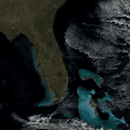
This dataset provides daily global surface reflectance data from the MODIS Terra satellite.
-
It includes 500-meter reflectance values and 1-kilometer observation and geolocation statistics.
-
The data is corrected for atmospheric effects to estimate ground-level spectral reflectance.
-
This dataset is superseded by MODIS/061/MOD09GA.
- Dataset Availability
- 2000-02-24T00:00:00Z–2017-03-30T00:00:00Z
- Dataset Producer
- NASA LP DAAC at the USGS EROS Center
- Cadence
- 1 Day
- Tags
Description
The MODIS Surface Reflectance products provide an estimate of the surface spectral reflectance as it would be measured at ground level in the absence of atmospheric scattering or absorption. Low-level data are corrected for atmospheric gases and aerosols, yielding a level-2 basis for several higher-order gridded level-2 (L2G) and level-3 products.
MOD09GA provides Bands 1-7 in a daily gridded L2G product in the Sinusoidal projection, including 500-meter reflectance values and 1-kilometer observation and geolocation statistics. 500-m Science Data Sets provided for this product include reflectance for Bands 1-7, a quality rating, observation coverage, observation number, and 250-m scan information. 1-kilometer Science Data Sets provided include number of observations, quality state, sensor angles, solar angles, geolocation flags, and orbit pointers.
Bands:
- num_observations_1km: Number of observations, 1km
- state_1km: Reflectance Data State QA
- Bit 0-1: cloud state bits
- 00 (0): clear
- 01 (1): cloudy
- 10 (2): mixed
- 11 (3): not set, assumed clear
- Bit 2: cloud shadow data (1 = yes)
- Bit 3-5: land/water flag
- 000 (0): shallow ocean
- 001 (1): land
- 010 (2): ocean coastlines and lake shorelines
- 011 (3): shallow inland water
- 100 (4): ephemeral water
- 101 (5): deep inland water
- 110 (6): continental/moderate ocean
- 111 (7): deep ocean
- Bit 6-7: aerosol quantity
- 00 (0): climatology
- 01 (1): low
- 10 (2): average
- 11 (3): high
- Bit 8-9: cirrus detected
- 00 (0): none
- 01 (1): small
- 10 (2): average
- 11 (3): high
- Bit 10: internal cloud algorithm flag data (1 = Cloud)
- Bit 11: internal fire algorithm flag data (1 = Fire)
- Bit 12: MOD35 snow/ice flag data (1 = yes)
- Bit 13: Pixel is adjacent to cloud data (1 = yes)
- Bit 14: BRDF correction performed data (1 = yes)
- Bit 15: internal snow mask data (1 = Snow)
- Bit 0-1: cloud state bits
- SensorZenith (degrees * 100): sensor zenith angle
- SensorAzimuth (degrees * 100): sensor azimuth angle
- Range (scale 25): pixel to sensor
- SolarZenith (degrees * 100): solar zenith angle
- SolarAzimuth (degrees * 100): solar azimuth angle
- gflags: Geolocation flags
- Bit 0-2: Fill
- Bit 3: Sensor range validity flag (0 = Valid)
- Bit 4: Digital elevation model quality flag (0 = Valid, 1 = Missing/inferior)
- Bit 5: Terrain data validity (0 = Valid)
- Bit 6: Ellipsoid intersection flag (0 = Valid intersection, 1 = No intersection)
- Bit 7: Input data flag (0 = Valid)
- orbit_pnt: Orbit pointer
- granule_pnt: Granule pointer (v6 only)
- num_observations_500m: Number of observations, 500m
- sur_refl_b01: 500m Surface Reflectance Band 1 (620-670 nm)
- sur_refl_b02: 500m Surface Reflectance Band 2 (841-876 nm)
- sur_refl_b03: 500m Surface Reflectance Band 3 (459-479 nm)
- sur_refl_b04: 500m Surface Reflectance Band 4 (545-565 nm)
- sur_refl_b05: 500m Surface Reflectance Band 5 (1230-1250 nm)
- sur_refl_b06: 500m Surface Reflectance Band 6 (1628-1652 nm)
- sur_refl_b07: 500m Surface Reflectance Band 7 (2105-2155 nm)
- QC_500m: 500m Reflectance Band Quality
- Bit 0-1: MODLAND QA bits
- 00 (0): corrected product produced at ideal quality all bands
- 01 (1): corrected product produced at less than ideal quality some or all bands
- 10 (2): corrected product not produced due to cloud effects all bands
- 11 (3): corrected product not produced due to other reasons some or all bands may be fill value [Note that a value of (11) overrides a value of (01)].
- Bit 2-5: band 1 data quality four bit range
- 0000 (0): highest quality
- 1000 (8): dead detector; data interpolated in L1B
- 1001 (9): solar zenith ≥ 86 degrees
- 1010 (10): solar zenith ≥ 85 and < 86 degrees
- 1011 (11): missing input
- 1100 (12): internal constant used in place of climatological data for at least one atmospheric constant
- 1101 (13): correction out of bounds pixel constrained to extreme allowable value
- 1110 (14): L1B data faulty
- 1111 (15): not processed due to deep ocean or clouds
- Bit 6-9: band 2 data quality four bit range
- Bit 10-13: band 3 data quality four bit range
- Bit 14-17: band 4 data quality four bit range
- Bit 18-21: band 5 data quality four bit range
- Bit 22-25: band 6 data quality four bit range
- Bit 26-29: band 7 data quality four bit range
- Bit 30: atmospheric correction performed data (1 = yes)
- Bit 31: adjacency correction performed data (1 = yes)
- Bit 0-1: MODLAND QA bits
- obscov_500m (%): Observation coverage, 500m
- iobs_res: Observation number in coarser grid
- q_scan: 250m scan value information
- Bit 0: missing observation in quadrant 4 [+0.5 row, +0.5 column] data (1 = yes)
- Bit 1: missing observation in quadrant 3 [+0.5 row, -0.5 column] data (1 = yes)
- Bit 2: missing observation in quadrant 2 [-0.5 row, +0.5 column]data (1 = yes)
- Bit 3: missing observation in quadrant 1 [-0.5 row, -0.5 column] data (1 = yes)
- Bit 4: scan of observation in quadrant 4 [+0.5 row, +0.5 column] data (0 = different, 1 = same)
- Bit 5: scan of observation in quadrant 3 [+0.5 row, -0.5 column] data (0 = different, 1 = same)
- Bit 6: scan of observation in quadrant 2 [-0.5 row, +0.5 column] data (0 = different, 1 = same)
- Bit 7: scan of observation in quadrant 1 [-0.5 row, -0.5 column] data (0 = different, 1 = same)
Please visit LP DAAC 'Citing Our Data' page for information on citing LP DAAC datasets.
Bands
Bands
| Name | Pixel Size | Description |
|---|
Terms of Use
Terms of Use
MODIS data and products acquired through the LP DAAC have no restrictions on subsequent use, sale, or redistribution.