The MODIS Surface Reflectance products
provide an estimate of the surface spectral reflectance as it would be
measured at ground level in the absence of atmospheric scattering or
absorption. Low-level data are corrected for atmospheric gases and
aerosols, yielding a level-2 basis for several higher-order gridded
level-2 (L2G) and level-3 products.
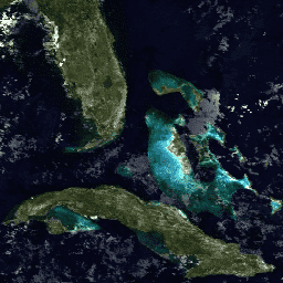
MOD09A1 provides
Bands 1-7 at 500-meter resolution in an 8-day gridded level-3 product in the
Sinusoidal projection. Each MOD09A1 pixel contains the best possible L2G
observation during an 8-day period as selected on the basis of high observation
coverage, low view angle, the absence of clouds or cloud shadow, and aerosol
loading. Science Data Sets provided for this product include reflectance values
for Bands 1-7, quality assessment, and the day of the year for the pixel along
with solar, view, and zenith angles.
The MODIS Surface Reflectance products provide an estimate of the surface spectral reflectance as it would be measured at ground level in the absence of atmospheric scattering or absorption. Low-level data are corrected for atmospheric gases and aerosols, yielding a level-2 basis for several higher-order gridded level-2 (L2G) and level-3 …
[[["Easy to understand","easyToUnderstand","thumb-up"],["Solved my problem","solvedMyProblem","thumb-up"],["Other","otherUp","thumb-up"]],[["Missing the information I need","missingTheInformationINeed","thumb-down"],["Too complicated / too many steps","tooComplicatedTooManySteps","thumb-down"],["Out of date","outOfDate","thumb-down"],["Samples / code issue","samplesCodeIssue","thumb-down"],["Other","otherDown","thumb-down"]],[],[[["\u003cp\u003eThe MOD21A1D dataset provides daily land surface temperature (LST) and emissivity data at a 1,000-meter resolution, derived from daytime MODIS observations.\u003c/p\u003e\n"],["\u003cp\u003eThe LST values are calculated as an average from cloud-free observations with good accuracies, weighted by observation coverage.\u003c/p\u003e\n"],["\u003cp\u003eData quality flags, emissivity bands, view zenith angle, and time of observation are included in the dataset along with LST.\u003c/p\u003e\n"],["\u003cp\u003eThe dataset covers the globe and is available from February 24, 2000, to October 19, 2024.\u003c/p\u003e\n"],["\u003cp\u003eMODIS data acquired through the LP DAAC has no restrictions on subsequent use, sale, or redistribution.\u003c/p\u003e\n"]]],[],null,["# MOD09A1.005 Surface Reflectance 8-Day Global 500m [deprecated]\n\n**Caution:** This dataset has been superseded by [MODIS/061/MOD09A1](/earth-engine/datasets/catalog/MODIS_061_MOD09A1). \n\nDataset Availability\n: 2000-02-18T00:00:00Z--2017-03-22T00:00:00Z\n\nDataset Provider\n:\n\n\n [NASA LP DAAC at the USGS EROS Center](https://lpdaac.usgs.gov/dataset_discovery/modis/modis_products_table/mod09a1)\n\nCadence\n: 8 Days\n\nTags\n:\n 8-day \n global \n mod09a1 \n modis \n satellite-imagery \n surface-reflectance \nterra \n\n#### Description\n\nThe MODIS Surface Reflectance products\nprovide an estimate of the surface spectral reflectance as it would be\nmeasured at ground level in the absence of atmospheric scattering or\nabsorption. Low-level data are corrected for atmospheric gases and\naerosols, yielding a level-2 basis for several higher-order gridded\nlevel-2 (L2G) and level-3 products.\n\nMOD09A1 provides\nBands 1-7 at 500-meter resolution in an 8-day gridded level-3 product in the\nSinusoidal projection. Each MOD09A1 pixel contains the best possible L2G\nobservation during an 8-day period as selected on the basis of high observation\ncoverage, low view angle, the absence of clouds or cloud shadow, and aerosol\nloading. Science Data Sets provided for this product include reflectance values\nfor Bands 1-7, quality assessment, and the day of the year for the pixel along\nwith solar, view, and zenith angles.\n\nPlease visit [LP DAAC 'Citing Our Data' page](https://lpdaac.usgs.gov/citing_our_data) for information on citing LP DAAC datasets.\n\n### Bands\n\n**Bands**\n\n| Name | Pixel Size | Description |\n|------|------------|-------------|\n\n### Terms of Use\n\n**Terms of Use**\n\nMODIS data and products acquired through the LP DAAC have no restrictions on subsequent use, sale, or redistribution.\n**Important:** Earth Engine is a platform for petabyte-scale scientific analysis and visualization of geospatial datasets, both for public benefit and for business and government users. Earth Engine is free to use for research, education, and nonprofit use. To get started, please [register for Earth Engine access.](https://console.cloud.google.com/earth-engine) \n[MOD09A1.005 Surface Reflectance 8-Day Global 500m \\[deprecated\\]](/earth-engine/datasets/catalog/MODIS_MOD09A1) \nThe MODIS Surface Reflectance products provide an estimate of the surface spectral reflectance as it would be measured at ground level in the absence of atmospheric scattering or absorption. Low-level data are corrected for atmospheric gases and aerosols, yielding a level-2 basis for several higher-order gridded level-2 (L2G) and level-3 ... \nMODIS/MOD09A1, 8-day,global,modis,satellite-imagery,surface-reflectance,terra \n2000-02-18T00:00:00Z/2017-03-22T00:00:00Z \n-90 -180 90 180 \nGoogle Earth Engine \nhttps://developers.google.com/earth-engine/datasets\n\n- [](https://doi.org/https://lpdaac.usgs.gov/dataset_discovery/modis/modis_products_table/mod09a1)\n- [](https://doi.org/https://developers.google.com/earth-engine/datasets/catalog/MODIS_MOD09A1)"]]