Page Summary
-
This dataset, providing the Enhanced Vegetation Index (EVI) from MODIS surface reflectance composites, is superseded by MODIS/MCD43A4_006_EVI.
-
The dataset offers 8-day cadence global data from February 18, 2000, to March 14, 2017.
-
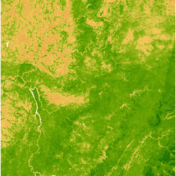
The EVI band measures vegetation index and ranges from -1.0 to 1.0 with a pixel size of 463.313 meters.
-
MODIS data and products acquired through the LP DAAC have no restrictions on subsequent use, while Earth Engine is free for research, education, and nonprofit use.
- Dataset Availability
- 2000-02-18T00:00:00Z–2017-03-14T00:00:00Z
- Dataset Producer
- Cadence
- 8 Days
- Tags
Description
The Enhanced Vegetation Index (EVI) is generated from the Near-IR, Red and Blue bands of each scene, and ranges in value from -1.0 to 1.0. See Huete et al. (2002) for details. This product is generated from the MODIS/MCD43A4 surface reflectance composites.
Bands
Bands
Pixel size: 463.313 meters (all bands)
| Name | Pixel Size | Description |
|---|---|---|
EVI |
463.313 meters | Enhanced Vegetation Index |
Terms of Use
Terms of Use
MODIS data and products acquired through the LP DAAC have no restrictions on subsequent use, sale, or redistribution.