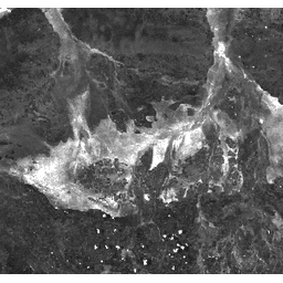
The Burn Area Index (BAI) is generated from the Red and
Near-IR bands, and measures the spectral distance of each pixel from a
reference spectral point (the measured reflectance of charcoal). This
index is intended to emphasize the charcoal signal in post-fire
images. See
Chuvieco et al. (2002)
for details. This product is generated from the MODIS/MCD43A4 surface reflectance composites.
Bands
Bands
Pixel size: 463.313 meters (all bands)
Name
Pixel Size
Description
BAI
463.313 meters
Burn Area Index
Terms of Use
Terms of Use
MODIS data and products acquired through the LP DAAC have no restrictions on subsequent use, sale, or redistribution.
The Burn Area Index (BAI) is generated from the Red and Near-IR bands, and measures the spectral distance of each pixel from a reference spectral point (the measured reflectance of charcoal). This index is intended to emphasize the charcoal signal in post-fire images. See Chuvieco et al. (2002) for details. …
[[["Easy to understand","easyToUnderstand","thumb-up"],["Solved my problem","solvedMyProblem","thumb-up"],["Other","otherUp","thumb-up"]],[["Missing the information I need","missingTheInformationINeed","thumb-down"],["Too complicated / too many steps","tooComplicatedTooManySteps","thumb-down"],["Out of date","outOfDate","thumb-down"],["Samples / code issue","samplesCodeIssue","thumb-down"],["Other","otherDown","thumb-down"]],[],[],["The dataset, MODIS/MCD43A4_BAI, provides the Burn Area Index (BAI), calculated from Red and Near-IR bands to highlight charcoal in post-fire images. It's derived from MODIS/MCD43A4 surface reflectance composites and has an 8-day cadence. The data is available from February 18, 2000, to March 14, 2017, with a 463.313-meter pixel size for the BAI band. It's accessible through Google Earth Engine, and is now superseded by MODIS/MCD43A4_006_BAI.\n"]]