Page Summary
-
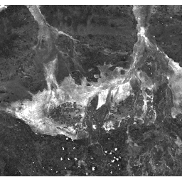
The Burn Area Index (BAI) is derived from Red and Near-IR bands to measure the spectral distance of each pixel from a reference charcoal spectral point, emphasizing the charcoal signal in post-fire images.
-
This dataset, provided by Google and generated from MODIS/006/MCD43A4 surface reflectance composites, has a daily cadence and is available from 2000-02-24 to 2023-02-10.
-
The dataset includes a single band named 'BAI' with a pixel size of 463.313 meters, representing the Burn Area Index.
-
There are no restrictions on the subsequent use, sale, or redistribution of MODIS data and products acquired through the LP DAAC.
-
The dataset can be explored and analyzed using Google Earth Engine, a platform for petabyte-scale geospatial analysis, which is free for research, education, and nonprofit use.
- Dataset Availability
- 2000-02-24T00:00:00Z–2023-02-10T00:00:00Z
- Dataset Producer
- Cadence
- 1 Day
- Tags
Description
The Burn Area Index (BAI) is generated from the Red and Near-IR bands, and measures the spectral distance of each pixel from a reference spectral point (the measured reflectance of charcoal). This index is intended to emphasize the charcoal signal in post-fire images. See Chuvieco et al. (2002) for details. This product is generated from the MODIS/006/MCD43A4 surface reflectance composites.
Bands
Bands
Pixel size: 463.313 meters (all bands)
| Name | Pixel Size | Description |
|---|---|---|
BAI |
463.313 meters | Burn Area Index |
Terms of Use
Terms of Use
MODIS data and products acquired through the LP DAAC have no restrictions on subsequent use, sale, or redistribution.
Explore with Earth Engine
Code Editor (JavaScript)
var dataset = ee.ImageCollection('MODIS/MCD43A4_006_BAI')
                  .filter(ee.Filter.date('2018-04-01', '2018-06-01'));
var scaled = dataset.select('BAI');
var scaledVis = {
  min: 0.0,
  max: 100.0,
};
Map.setCenter(-7.03125, 31.0529339857, 2);
Map.addLayer(scaled, scaledVis, 'Scaled');