Send feedback
MYD09GA.061 Aqua Surface Reflectance Daily Global 1km and 500m
Stay organized with collections
Save and categorize content based on your preferences.
outlined_flag
The MODIS Surface Reflectance products provide an estimate of surface spectral reflectance corrected for atmospheric effects.
The MYD09GA version 6.1 dataset provides daily gridded L2G products in the sinusoidal projection with 500m reflectance values and 1km observation/geolocation statistics.
This dataset includes various bands for surface reflectance (bands 1-7) as well as bands providing observation, state, angle, range, and quality information.
The dataset is available from 2002-07-04 to 2025-10-14 with a daily cadence.
MODIS data and products from LP DAAC have no restrictions on subsequent use, sale, or redistribution.
Description
The MODIS Surface Reflectance products provide an estimate
of the surface spectral reflectance as it would be measured at
ground level in the absence of atmospheric scattering or absorption.
Low-level data are corrected for atmospheric gases and aerosols.
MYD09GA version 6.1 provides bands 1-7 in a daily gridded L2G product
in the sinusoidal projection, including 500m reflectance values
and 1km observation and geolocation statistics.
Documentation:
Bands
Bands
Pixel size: varies
Name
Units
Min
Max
Scale
Pixel Size
Wavelength
Description
num_observations_1km
2
127
1000 meters
None
Number of observations per 1K pixel
state_1km
1000 meters
None
Reflectance data state QA
Bitmask for state_1km
Bits 0-1: Cloud state
0: Clear
1: Cloudy
2: Mixed
3: Not set, assumed clear
Bit 2: Cloud shadow
Bits 3-5: Land/water flag
0: Shallow ocean
1: Land
2: Ocean coastlines and lake shorelines
3: Shallow inland water
4: Ephemeral water
5: Deep inland water
6: Continental/moderate ocean
7: Deep ocean
Bits 6-7: Aerosol quantity
0: Climatology
1: Low
2: Average
3: High
Bits 8-9: Cirrus detected
0: None
1: Small
2: Average
3: High
Bit 10: Internal cloud algorithm flag
Bit 11: Internal fire algorithm flag
Bit 12: MOD35 snow/ice flag
Bit 13: Pixel is adjacent to cloud
Bit 14: BRDF correction performed data
Bit 15: Internal snow mask
SensorZenithdeg
0
18000
0.01
1000 meters
None
Sensor zenith angle
SensorAzimuthdeg
-18000
18000
0.01
1000 meters
None
Sensor azimuth angle
Rangem
27000
65535
25
1000 meters
None
Distance to sensor
SolarZenithdeg
0
18000
0.01
1000 meters
None
Solar zenith angle
SolarAzimuthdeg
-18000
18000
0.01
1000 meters
None
Solar azimuth angle
gflags
1000 meters
None
Geolocation flags
Bitmask for gflags
Bits 0-2: Fill
Bit 3: Sensor range validity flag
Bit 4: Digital elevation model quality flag
0: Valid
1: Missing/inferior
Bit 5: Terrain data validity
Bit 6: Ellipsoid intersection flag
0: Valid intersection
1: No intersection
Bit 7: Input data flag
orbit_pnt
0
15
1000 meters
None
Orbit pointer
granule_pnt
0
254
1000 meters
None
Granule pointer
num_observations_500m
0
127
500 meters
None
Number of observations
sur_refl_b01
-100
16000
0.0001
500 meters
620-670nm
Surface reflectance for band 1
sur_refl_b02
-100
16000
0.0001
500 meters
841-876nm
Surface reflectance for band 2
sur_refl_b03
-100
16000
0.0001
500 meters
459-479nm
Surface reflectance for band 3
sur_refl_b04
-100
16000
0.0001
500 meters
545-565nm
Surface reflectance for band 4
sur_refl_b05
-100
16000
0.0001
500 meters
1230-1250nm
Surface reflectance for band 5
sur_refl_b06
-100
16000
0.0001
500 meters
1628-1652nm
Surface reflectance for band 6
sur_refl_b07
-100
16000
0.0001
500 meters
2105-2155nm
Surface reflectance for band 7
QC_500m
500 meters
None
Surface reflectance quality assurance
Bitmask for QC_500m
Bits 0-1: MODLAND QA bits
0: Corrected product produced at ideal quality - all bands
1: Corrected product produced at less than ideal quality - some or all bands
2: Corrected product not produced due to cloud effects - all bands
3: Corrected product not produced for other reasons
- some or all bands, may be fill value (11) [Note that
a value of (11) overrides a value of (01)]
Bits 2-5: Band 1 data quality, four bit range
0: Highest quality
7: Noisy detector
8: Dead detector, data interpolated in L1B
9: Solar zenith >= 86 degrees
10: Solar zenith >= 85 and < 86 degrees
11: Missing input
12: Internal constant used in place of climatological
data for at least one atmospheric constant
13: Correction out of bounds, pixel constrained to extreme allowable value
14: L1B data faulty
15: Not processed due to deep ocean or clouds
Bits 6-9: Band 2 data quality, four bit range
0: Highest quality
7: Noisy detector
8: Dead detector, data interpolated in L1B
9: Solar zenith >= 86 degrees
10: Solar zenith >= 85 and < 86 degrees
11: Missing input
12: Internal constant used in place of climatological
data for at least one atmospheric constant
13: Correction out of bounds, pixel constrained to extreme allowable value
14: L1B data faulty
15: Not processed due to deep ocean or clouds
Bits 10-13: Band 3 data quality, four bit range
0: Highest quality
7: Noisy detector
8: Dead detector, data interpolated in L1B
9: Solar zenith >= 86 degrees
10: Solar zenith >= 85 and < 86 degrees
11: Missing input
12: Internal constant used in place of climatological
data for at least one atmospheric constant
13: Correction out of bounds, pixel constrained to extreme allowable value
14: L1B data faulty
15: Not processed due to deep ocean or clouds
Bits 14-17: Band 4 data quality, four bit range
0: Highest quality
7: Noisy detector
8: Dead detector, data interpolated in L1B
9: Solar zenith >= 86 degrees
10: Solar zenith >= 85 and < 86 degrees
11: Missing input
12: Internal constant used in place of climatological
data for at least one atmospheric constant
13: Correction out of bounds, pixel constrained to extreme allowable value
14: L1B data faulty
15: Not processed due to deep ocean or clouds
Bits 18-21: Band 5 data quality, four bit range
0: Highest quality
7: Noisy detector
8: Dead detector, data interpolated in L1B
9: Solar zenith >= 86 degrees
10: Solar zenith >= 85 and < 86 degrees
11: Missing input
12: Internal constant used in place of climatological
data for at least one atmospheric constant
13: Correction out of bounds, pixel constrained to extreme allowable value
14: L1B data faulty
15: Not processed due to deep ocean or clouds
Bits 22-25: Band 6 data quality, four bit range
0: Highest quality
7: Noisy detector
8: Dead detector, data interpolated in L1B
9: Solar zenith >= 86 degrees
10: Solar zenith >= 85 and < 86 degrees
11: Missing input
12: Internal constant used in place of climatological
data for at least one atmospheric constant
13: Correction out of bounds, pixel constrained to extreme allowable value
14: L1B data faulty
15: Not processed due to deep ocean or clouds
Bits 26-29: Band 7 data quality, four bit range
0: Highest quality
7: Noisy detector
8: Dead detector, data interpolated in L1B
9: Solar zenith >= 86 degrees
10: Solar zenith >= 85 and < 86 degrees
11: Missing input
12: Internal constant used in place of climatological
data for at least one atmospheric constant
13: Correction out of bounds, pixel constrained
to extreme allowable value
14: L1B data faulty
15: Not processed due to deep ocean or clouds
Bit 30: Atmospheric correction performed
Bit 31: Adjacency correction performed
obscov_500m
0
100
500 meters
None
Observation coverage percent
iobs_res
0
254
500 meters
None
Observation number in coarser grid
q_scan
500 meters
None
250m scan value information
Bitmask for q_scan
Bit 0: Scan of observation in quadrant 1 [-0.5 row, -0.5 column]
Bit 1: Scan of observation in quadrant 2 [-0.5 row, +0.5 column]
Bit 2: Scan of observation in quadrant 3 [+0.5 row, -0.5 column]
Bit 3: Scan of observation in quadrant 4 [+0.5 row, +0.5 column]
Bit 4: Missing observation in quadrant 1 [-0.5 row, -0.5 column]
Bit 5: Missing observation in quadrant 2 [-0.5 row, +0.5 column]
Bit 6: Missing observation in quadrant 3 [+0.5 row, -0.5 column]
Bit 7: Missing observation in quadrant 4 [+0.5 row, +0.5 column]
Terms of Use
Terms of Use
MODIS data and products acquired through the LP DAAC
have no restrictions on subsequent use, sale, or redistribution.
Explore with Earth Engine
Important:
Earth Engine is a platform for petabyte-scale scientific analysis and visualization of
geospatial datasets, both for public benefit and for business and government users.
Earth Engine is free to use for research, education, and nonprofit use. To get started, please
register for Earth Engine access.
Code Editor (JavaScript)
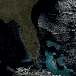
var dataset = ee . ImageCollection ( 'MODIS/061/MYD09GA' )
. filter ( ee . Filter . date ( '2018-04-01' , '2018-06-01' ));
var trueColor143 =
dataset . select ([ 'sur_refl_b01' , 'sur_refl_b04' , 'sur_refl_b03' ]);
var trueColor143Vis = {
min : - 100.0 ,
max : 8000.0 ,
};
Map . setCenter ( - 7.03125 , 31.0529339857 , 2 );
Map . addLayer ( trueColor143 , trueColor143Vis , 'True Color (143)' );
Open in Code Editor
Need to tell us more?
[[["Easy to understand","easyToUnderstand","thumb-up"],["Solved my problem","solvedMyProblem","thumb-up"],["Other","otherUp","thumb-up"]],[["Missing the information I need","missingTheInformationINeed","thumb-down"],["Too complicated / too many steps","tooComplicatedTooManySteps","thumb-down"],["Out of date","outOfDate","thumb-down"],["Samples / code issue","samplesCodeIssue","thumb-down"],["Other","otherDown","thumb-down"]],[],[],[]]