Page Summary
-
The MODIS MCD12Q1 Version 6.1 data product provides global land cover types annually, derived from supervised classifications of MODIS Terra and Aqua reflectance data.
-
This dataset includes land cover types based on multiple classification schemes, such as IGBP, UMD, LAI, BIOME-BGC, and PFT, along with FAO LCCS layers.
-
Additional layers like Land Cover Property and Assessment layers, Quality Control, and a Land Water Mask are also provided within the dataset.
-
The dataset is available from 2001 to 2024 with a yearly cadence and has a pixel size of 500 meters.
- Dataset Availability
- 2001-01-01T00:00:00Z–2024-01-01T00:00:00Z
- Dataset Producer
- NASA LP DAAC at the USGS EROS Center
- Cadence
- 1 Year
- Tags
Description
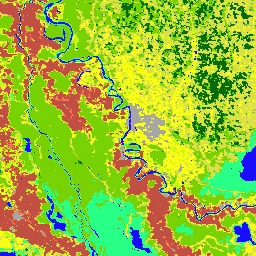
The Terra and Aqua combined Moderate Resolution Imaging Spectroradiometer (MODIS) Land Cover Type (MCD12Q1) Version 6.1 data product provides global land cover types at yearly intervals. The MCD12Q1 Version 6.1 data product is derived using supervised classifications of MODIS Terra and Aqua reflectance data. Land cover types are derived from the International Geosphere-Biosphere Programme (IGBP), University of Maryland (UMD), Leaf Area Index (LAI), BIOME-Biogeochemical Cycles (BGC), and Plant Functional Types (PFT) classification schemes. The supervised classifications then underwent additional post-processing that incorporate prior knowledge and ancillary information to further refine specific classes. Additional land cover property assessment layers are provided by the Food and Agriculture Organization (FAO) Land Cover Classification System (LCCS) for land cover, land use, and surface hydrology.
Layers for Land Cover Type 1-5, Land Cover Property 1-3, Land Cover Property Assessment 1-3, Land Cover Quality Control (QC), and a Land Water Mask are also provided.
Documentation:
Bands
Bands
Pixel size: 500 meters (all bands)
| Name | Units | Min | Max | Pixel Size | Description |
|---|---|---|---|---|---|
LC_Type1 |
500 meters | Land Cover Type 1: Annual International Geosphere-Biosphere Programme (IGBP) classification |
|||
LC_Type2 |
500 meters | Land Cover Type 2: Annual University of Maryland (UMD) classification |
|||
LC_Type3 |
500 meters | Land Cover Type 3: Annual Leaf Area Index (LAI) classification |
|||
LC_Type4 |
500 meters | Land Cover Type 4: Annual BIOME-Biogeochemical Cycles (BGC) classification |
|||
LC_Type5 |
500 meters | Land Cover Type 5: Annual Plant Functional Types classification |
|||
LC_Prop1_Assessment |
% | 0 | 100 | 500 meters | LCCS1 land cover layer confidence |
LC_Prop2_Assessment |
% | 0 | 100 | 500 meters | LCCS2 land use layer confidence |
LC_Prop3_Assessment |
% | 0 | 100 | 500 meters | LCCS3 surface hydrology layer confidence |
LC_Prop1 |
500 meters | FAO-Land Cover Classification System 1 (LCCS1) land cover layer |
|||
LC_Prop2 |
500 meters | FAO-LCCS2 land use layer |
|||
LC_Prop3 |
500 meters | FAO-LCCS3 surface hydrology layer |
|||
QC |
500 meters | Product quality flags |
|||
LW |
500 meters | Binary land (class 2) / water (class 1) mask derived from MOD44W |
LC_Type1 Class Table
| Value | Color | Description |
|---|---|---|
| 1 | #05450a | Evergreen Needleleaf Forests: dominated by evergreen conifer trees (canopy >2m). Tree cover >60%. |
| 2 | #086a10 | Evergreen Broadleaf Forests: dominated by evergreen broadleaf and palmate trees (canopy >2m). Tree cover >60%. |
| 3 | #54a708 | Deciduous Needleleaf Forests: dominated by deciduous needleleaf (larch) trees (canopy >2m). Tree cover >60%. |
| 4 | #78d203 | Deciduous Broadleaf Forests: dominated by deciduous broadleaf trees (canopy >2m). Tree cover >60%. |
| 5 | #009900 | Mixed Forests: dominated by neither deciduous nor evergreen (40-60% of each) tree type (canopy >2m). Tree cover >60%. |
| 6 | #c6b044 | Closed Shrublands: dominated by woody perennials (1-2m height) >60% cover. |
| 7 | #dcd159 | Open Shrublands: dominated by woody perennials (1-2m height) 10-60% cover. |
| 8 | #dade48 | Woody Savannas: tree cover 30-60% (canopy >2m). |
| 9 | #fbff13 | Savannas: tree cover 10-30% (canopy >2m). |
| 10 | #b6ff05 | Grasslands: dominated by herbaceous annuals (<2m). |
| 11 | #27ff87 | Permanent Wetlands: permanently inundated lands with 30-60% water cover and >10% vegetated cover. |
| 12 | #c24f44 | cropland. |
| 13 | #a5a5a5 | Urban and Built-up Lands: at least 30% impervious surface area including building materials, asphalt and vehicles. |
| 14 | #ff6d4c | Cropland/Natural Vegetation Mosaics: mosaics of small-scale cultivation 40-60% with natural tree, shrub, or herbaceous vegetation. |
| 15 | #69fff8 | Permanent Snow and Ice: at least 60% of area is covered by snow and ice for at least 10 months of the year. |
| 16 | #f9ffa4 | (sand, rock, soil) areas with less than 10% vegetation. |
| 17 | #1c0dff | Water Bodies: at least 60% of area is covered by permanent water bodies. |
LC_Type2 Class Table
| Value | Color | Description |
|---|---|---|
| 0 | #1c0dff | Water Bodies: at least 60% of area is covered by permanent water bodies. |
| 1 | #05450a | Evergreen Needleleaf Forests: dominated by evergreen conifer trees (canopy >2m). Tree cover >60%. |
| 2 | #086a10 | Evergreen Broadleaf Forests: dominated by evergreen broadleaf and palmate trees (canopy >2m). Tree cover >60%. |
| 3 | #54a708 | Deciduous Needleleaf Forests: dominated by deciduous needleleaf (larch) trees (canopy >2m). Tree cover >60%. |
| 4 | #78d203 | Deciduous Broadleaf Forests: dominated by deciduous broadleaf trees (canopy >2m). Tree cover >60%. |
| 5 | #009900 | Mixed Forests: dominated by neither deciduous nor evergreen (40-60% of each) tree type (canopy >2m). Tree cover >60%. |
| 6 | #c6b044 | Closed Shrublands: dominated by woody perennials (1-2m height) >60% cover. |
| 7 | #dcd159 | Open Shrublands: dominated by woody perennials (1-2m height) 10-60% cover. |
| 8 | #dade48 | Woody Savannas: tree cover 30-60% (canopy >2m). |
| 9 | #fbff13 | Savannas: tree cover 10-30% (canopy >2m). |
| 10 | #b6ff05 | Grasslands: dominated by herbaceous annuals (<2m). |
| 11 | #27ff87 | Permanent Wetlands: permanently inundated lands with 30-60% water cover and >10% vegetated cover. |
| 12 | #c24f44 | cropland. |
| 13 | #a5a5a5 | Urban and Built-up Lands: at least 30% impervious surface area including building materials, asphalt and vehicles. |
| 14 | #ff6d4c | Cropland/Natural Vegetation Mosaics: mosaics of small-scale cultivation 40-60% with natural tree, shrub, or herbaceous vegetation. |
| 15 | #f9ffa4 | Non-Vegetated Lands: at least 60% of area is non-vegetated barren (sand, rock, soil) or permanent snow and ice with less than 10% vegetation. |
LC_Type3 Class Table
| Value | Color | Description |
|---|---|---|
| 0 | #1c0dff | Water Bodies: at least 60% of area is covered by permanent water bodies. |
| 1 | #b6ff05 | Grasslands: dominated by herbaceous annuals (<2m) including cereal croplands. |
| 2 | #dcd159 | Shrublands: shrub (1-2m) cover >10%. |
| 3 | #c24f44 | Broadleaf Croplands: bominated by herbaceous annuals (<2m) that are cultivated with broadleaf crops. |
| 4 | #fbff13 | Savannas: between 10-60% tree cover (>2m). |
| 5 | #086a10 | Evergreen Broadleaf Forests: dominated by evergreen broadleaf and palmate trees (canopy >2m). Tree cover >60%. |
| 6 | #78d203 | Deciduous Broadleaf Forests: dominated by deciduous broadleaf trees (canopy >2m). Tree cover >60%. |
| 7 | #05450a | Evergreen Needleleaf Forests: dominated by evergreen conifer trees (canopy >2m). Tree cover >60%. |
| 8 | #54a708 | Deciduous Needleleaf Forests: dominated by deciduous needleleaf (larch) trees (canopy >2m). Tree cover >60%. |
| 9 | #f9ffa4 | Non-Vegetated Lands: at least 60% of area is non-vegetated barren (sand, rock, soil) or permanent snow and ice with less than 10% vegetation. |
| 10 | #a5a5a5 | Urban and Built-up Lands: at least 30% impervious surface area including building materials, asphalt and vehicles. |
LC_Type4 Class Table
| Value | Color | Description |
|---|---|---|
| 0 | #1c0dff | Water Bodies: at least 60% of area is covered by permanent water bodies. |
| 1 | #05450a | Evergreen Needleleaf Vegetation: dominated by evergreen conifer trees and shrubs (>1m). Woody vegetation cover >10%. |
| 2 | #086a10 | Evergreen Broadleaf Vegetation: dominated by evergreen broadleaf and palmate trees and shrubs (>1m). Woody vegetation cover
|
| 3 | #54a708 | Deciduous Needleleaf Vegetation: dominated by deciduous needleleaf (larch) trees and shrubs (>1m). Woody vegetation cover
|
| 4 | #78d203 | Deciduous Broadleaf Vegetation: dominated by deciduous broadleaf trees and shrubs (>1m). Woody vegetation cover >10%. |
| 5 | #009900 | Annual Broadleaf Vegetation: dominated by herbaceous annuals (<2m). At least 60% cultivated broadleaf crops. |
| 6 | #b6ff05 | Annual Grass Vegetation: dominated by herbaceous annuals (<2m) including cereal croplands. |
| 7 | #f9ffa4 | Non-Vegetated Lands: at least 60% of area is non-vegetated barren (sand, rock, soil) or permanent snow/ice with less than 10% vegetation. |
| 8 | #a5a5a5 | Urban and Built-up Lands: at least 30% impervious surface area including building materials, asphalt, and vehicles. |
LC_Type5 Class Table
| Value | Color | Description |
|---|---|---|
| 0 | #1c0dff | Water Bodies: at least 60% of area is covered by permanent water bodies. |
| 1 | #05450a | Evergreen Needleleaf Trees: dominated by evergreen conifer trees (>2m). Tree cover >10%. |
| 2 | #086a10 | Evergreen Broadleaf Trees: dominated by evergreen broadleaf and palmate trees (>2m). Tree cover >10%. |
| 3 | #54a708 | Deciduous Needleleaf Trees: dominated by deciduous needleleaf (larch) trees (>2m). Tree cover >10%. |
| 4 | #78d203 | Deciduous Broadleaf Trees: dominated by deciduous broadleaf trees (>2m). Tree cover >10%. |
| 5 | #dcd159 | Shrub: Shrub (1-2m) cover >10%. |
| 6 | #b6ff05 | not cultivated. |
| 7 | #dade48 | Cereal Croplands: dominated by herbaceous annuals (<2m). At least 60% cultivated cereal crops. |
| 8 | #c24f44 | Broadleaf Croplands: dominated by herbaceous annuals (<2m). At least 60% cultivated broadleaf crops. |
| 9 | #a5a5a5 | Urban and Built-up Lands: at least 30% impervious surface area including building materials, asphalt, and vehicles. |
| 10 | #69fff8 | Permanent Snow and Ice: at least 60% of area is covered by snow and ice for at least 10 months of the year. |
| 11 | #f9ffa4 | Non-Vegetated Lands: at least 60% of area is non-vegetated barren (sand, rock, soil) with less than 10% vegetation. |
LC_Prop1 Class Table
| Value | Color | Description |
|---|---|---|
| 1 | #f9ffa4 | (sand, rock, soil) or permanent snow/ice with less than 10% vegetation. |
| 2 | #69fff8 | Permanent Snow and Ice: at least 60% of area is covered by snow and ice for at least 10 months of the year. |
| 3 | #1c0dff | Water Bodies: at least 60% of area is covered by permanent water bodies. |
| 11 | #05450a | Evergreen Needleleaf Forests: dominated by evergreen conifer trees (>2m). Tree cover >60%. |
| 12 | #086a10 | Evergreen Broadleaf Forests: dominated by evergreen broadleaf and palmate trees (>2m). Tree cover >60%. |
| 13 | #54a708 | Deciduous Needleleaf Forests: dominated by deciduous needleleaf (larch) trees (>2m). Tree cover >60%. |
| 14 | #78d203 | Deciduous Broadleaf Forests: dominated by deciduous broadleaf trees (>2m). Tree cover >60%. |
| 15 | #005a00 | Mixed Broadleaf/Needleleaf Forests: co-dominated (40-60%) by broadleaf deciduous and evergreen needleleaf tree (>2m) types. Tree cover >60%. |
| 16 | #009900 | Mixed Broadleaf Evergreen/Deciduous Forests: co-dominated (40-60%) by broadleaf evergreen and deciduous tree (>2m) types. Tree cover >60%. |
| 21 | #006c00 | Open Forests: tree cover 30-60% (canopy >2m). |
| 22 | #00d000 | Sparse Forests: tree cover 10-30% (canopy >2m). |
| 31 | #b6ff05 | Dense Herbaceous: dominated by herbaceous annuals (<2m) at least 60% cover. |
| 32 | #98d604 | Sparse Herbaceous: dominated by herbaceous annuals (<2m) 10-60% cover. |
| 41 | #dcd159 | Dense Shrublands: dominated by woody perennials (1-2m)
|
| 42 | #f1fb58 | Shrubland/Grassland Mosaics: dominated by woody perennials (1-2m) 10-60% cover with dense herbaceous annual understory. |
| 43 | #fbee65 | Sparse Shrublands: dominated by woody perennials (1-2m) 10-60% cover with minimal herbaceous understory. |
LC_Prop2 Class Table
| Value | Color | Description |
|---|---|---|
| 1 | #f9ffa4 | (sand, rock, soil) or permanent snow/ice with less than 10% vegetation. |
| 2 | #69fff8 | Permanent Snow and Ice: at least 60% of area is covered by snow and ice for at least 10 months of the year. |
| 3 | #1c0dff | Water Bodies: at least 60% of area is covered by permanent water bodies. |
| 9 | #a5a5a5 | Urban and Built-up Lands: at least 30% of area is made up ofimpervious surfaces including building materials, asphalt, and vehicles. |
| 10 | #003f00 | Dense Forests: tree cover >60% (canopy >2m). |
| 20 | #006c00 | Open Forests: tree cover 10-60% (canopy >2m). |
| 25 | #e3ff77 | Forest/Cropland Mosaics: mosaics of small-scale cultivation 40-60% with >10% natural tree cover. |
| 30 | #b6ff05 | Natural Herbaceous: dominated by herbaceous annuals (<2m). At least 10% cover. |
| 35 | #93ce04 | Natural Herbaceous/Croplands Mosaics: mosaics of small-scale cultivation 40-60% with natural shrub or herbaceous vegetation. |
| 36 | #77a703 | Herbaceous Croplands: dominated by herbaceous annuals (<2m). At least 60% cover. Cultivated fraction >60%. |
| 40 | #dcd159 | Shrublands: shrub cover >60% (1-2m). |
LC_Prop3 Class Table
| Value | Color | Description |
|---|---|---|
| 1 | #f9ffa4 | (sand, rock, soil) or permanent snow/ice with less than 10% vegetation. |
| 2 | #69fff8 | Permanent Snow and Ice: at least 60% of area is covered by snow and ice for at least 10 months of the year. |
| 3 | #1c0dff | Water Bodies: at least 60% of area is covered by permanent water bodies. |
| 10 | #003f00 | Dense Forests: tree cover >60% (canopy >2m). |
| 20 | #006c00 | Open Forests: tree cover 10-60% (canopy >2m). |
| 27 | #72834a | Woody Wetlands: shrub and tree cover >10% (>1m). Permanently or seasonally inundated. |
| 30 | #b6ff05 | Grasslands: dominated by herbaceous annuals (<2m) >10% cover. |
| 40 | #c6b044 | Shrublands: shrub cover >60% (1-2m). |
| 50 | #3aba73 | Herbaceous Wetlands: dominated by herbaceous annuals (<2m) >10% cover. Permanently or seasonally inundated. |
| 51 | #1e9db3 | months of the year. |
QC Class Table
| Value | Color | Description |
|---|---|---|
| 0 | None | Classified land: has a classification label and is land according to the water mask. |
| 1 | None | Unclassified land: not classified because of missing data but land according to the water mask, labeled as barren. |
| 2 | None | Classified water: has a classification label and is water according to the water mask. |
| 3 | None | Unclassified water: not classified because of missing data but water according to the water mask. |
| 4 | None | Classified sea ice: classified as snow/ice but water mask says it is water and less than 100m elevation, switched to water. |
| 5 | None | Misclassified water: classified as water but water mask says it is land, switched to secondary label. |
| 6 | None | Omitted snow/ice: land according to the water mask that was classified as something other than snow but with a maximum annual temperature below 1°C, relabeled as snow/ice. |
| 7 | None | Misclassified snow/ice: land according to the water mask that was classified as snow but with a minimum annual temperature greater than 1°C, relabeled as barren. |
| 8 | None | Backfilled label: missing label from stabilization, filled with the pre-stabilized result. |
| 9 | None | Forest type changed: climate-based change to forest class. |
LW Class Table
| Value | Color | Description |
|---|---|---|
| 1 | #1c0dff | Water |
| 2 | #f9ffa4 | Land, |
Terms of Use
Terms of Use
MODIS data and products acquired through the LP DAAC have no restrictions on subsequent use, sale, or redistribution.
Citations
Please visit LP DAAC 'Citing Our Data' page for information on citing LP DAAC datasets.
DOIs
Explore with Earth Engine
Code Editor (JavaScript)
var dataset = ee.ImageCollection('MODIS/061/MCD12Q1');
var igbpLandCover = dataset.select('LC_Type1');
var igbpLandCoverVis = {
  min: 1.0,
  max: 17.0,
  palette: [
    '05450a', '086a10', '54a708', '78d203', '009900', 'c6b044', 'dcd159',
    'dade48', 'fbff13', 'b6ff05', '27ff87', 'c24f44', 'a5a5a5', 'ff6d4c',
    '69fff8', 'f9ffa4', '1c0dff'
  ],
};
Map.setCenter(6.746, 46.529, 6);
Map.addLayer(igbpLandCover, igbpLandCoverVis, 'IGBP Land Cover');
import ee
import geemap.core as geemap
Colab (Python)
dataset = ee.ImageCollection('MODIS/061/MCD12Q1')

igbp_land_cover = dataset.select('LC_Type1')

igbp_land_cover_vis = {
    'min': 1.0,
    'max': 17.0,
    'palette': [
        '05450a', '086a10', '54a708', '78d203', '009900', 'c6b044', 'dcd159',
        'dade48', 'fbff13', 'b6ff05', '27ff87', 'c24f44', 'a5a5a5', 'ff6d4c',
        '69fff8', 'f9ffa4', '1c0dff'
    ],
}

m = geemap.Map()
m.set_center(6.746, 46.529, 6)
m.add_layer(igbp_land_cover, igbp_land_cover_vis, 'IGBP Land Cover')
m