MYD09Q1.006 Aqua Surface Reflectance 8-Day Global 250m [deprecated]
Stay organized with collections
Save and categorize content based on your preferences.
Page Summary
This dataset, MODIS/006/MYD09Q1, is now superseded by MODIS/061/MYD09Q1.
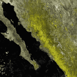
The MYD09Q1 product provides an estimate of surface spectral reflectance for bands 1 and 2 at 250m resolution, corrected for atmospheric conditions.
The dataset includes reflectance bands, a quality layer, and is available from 2002-07-04 to 2023-02-18 with an 8-day cadence.
Data quality is determined based on factors like observation coverage, view angle, cloud presence, and aerosol loading.
MODIS data from LP DAAC have no restrictions on use, sale, or redistribution.
The MYD09Q1 product provides an estimate of the surface
spectral reflectance of bands 1 and 2 at 250m resolution and corrected
for atmospheric conditions such as gasses, aerosols, and Rayleigh
scattering. Along with the two reflectance bands, a quality layer
is also included. For each pixel, a value is selected from all
the acquisitions within the 8-day composite on the basis of high
observation coverage, low view angle, the absence of clouds or
cloud shadow, and aerosol loading.
The MYD09Q1 product provides an estimate of the surface spectral reflectance of bands 1 and 2 at 250m resolution and corrected for atmospheric conditions such as gasses, aerosols, and Rayleigh scattering. Along with the two reflectance bands, a quality layer is also included. For each pixel, a value is selected …
[[["Easy to understand","easyToUnderstand","thumb-up"],["Solved my problem","solvedMyProblem","thumb-up"],["Other","otherUp","thumb-up"]],[["Missing the information I need","missingTheInformationINeed","thumb-down"],["Too complicated / too many steps","tooComplicatedTooManySteps","thumb-down"],["Out of date","outOfDate","thumb-down"],["Samples / code issue","samplesCodeIssue","thumb-down"],["Other","otherDown","thumb-down"]],[],[],["This dataset, MODIS/006/MYD09Q1, offers 8-day composites of surface spectral reflectance for bands 1 and 2 at 250m resolution, corrected for atmospheric conditions. Data spans from July 4, 2002, to February 18, 2023. Each pixel's value is selected from multiple daily acquisitions based on optimal observation coverage and minimal atmospheric interference. A quality layer and a state layer are also included. It is available on Google Earth Engine. The data is deprecated, superseded by MODIS/061/MYD09Q1.\n"]]