Page Summary
-
This dataset contains monthly global atmosphere data including aerosol, ozone, water vapor, and cloud properties from 2002 to 2018.
-
The data is provided at a 1 x 1 degree grid average resolution and is superseded by the MODIS/061/MYD08_M3 dataset.
-
The dataset is available in the public domain without restriction on use and distribution.
-
The product is produced by NASA LAADS DAAC at NASA Goddard Space Flight Center.
- Dataset Availability
- 2002-07-01T00:00:00Z–2018-04-01T00:00:00Z
- Dataset Producer
- NASA LAADS DAAC at NASA Goddard Space Flight Center
- Cadence
- 1 Month
- Tags
Description
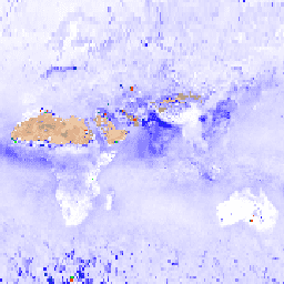
MYD08_M3 V6 is an atmosphere global product that contains monthly 1 x 1 degree grid average values of atmospheric parameters. These parameters are related to atmospheric aerosol particle properties, total ozone burden, atmospheric water vapor, cloud optical and physical properties, and atmospheric stability indices. The product also provides means, standard deviations, QA weighted statistics, log-normal distributions, uncertainty estimates, and statistics for fractions of pixels that satisfy some condition. Below is a subset of the bands, for a complete list see the MOD08 Band List.
Documentation:
Bands
Bands
Pixel size: 111320 meters (all bands)
| Name | Min | Max | Scale | Pixel Size | Description |
|---|---|---|---|---|---|
Aerosol_Optical_Depth_Land_Ocean_Mean_Mean |
-100 | 5000 | 0.001 | 111320 meters | Aerosol optical thickness at 0.55 microns for both ocean (best) and land (corrected): mean of daily mean |
Aerosol_Optical_Depth_Land_Ocean_Std_Deviation_Mean |
-100 | 5000 | 0.001 | 111320 meters | Aerosol optical thickness at 0.55 microns for both ocean (best) and land (corrected): mean of daily standard deviation |
Aerosol_Optical_Depth_Land_QA_Mean_Mean_470 |
-100 | 5000 | 0.001 | 111320 meters | Corrected aerosol optical depth (land) at 0.47 microns: mean of level-3 QA weighted mean |
Aerosol_Optical_Depth_Land_QA_Std_Deviation_Mean_470 |
-100 | 5000 | 0.001 | 111320 meters | Corrected aerosol optical depth (land) at 0.47 microns: mean of level-3 weighted QA standard deviation |
Cirrus_Fraction_SWIR_FMean |
0 | 10000 | 0.0001 | 111320 meters | Cirrus area fraction: mean of daily fraction |
Cirrus_Fraction_SWIR_FStd |
0 | 10000 | 0.0001 | 111320 meters | Cirrus area fraction: standard deviation of daily fraction |
Cloud_Optical_Thickness_Liquid_Log_Mean_Mean |
0 | 4176 | 0.001 | 111320 meters | Liquid water cloud optical thickness: mean of daily log mean |
Cloud_Optical_Thickness_Liquid_Log_Std_Deviation_Mean |
0 | 4176 | 0.001 | 111320 meters | Liquid water cloud optical thickness: mean of daily log standard deviation |
Cloud_Optical_Thickness_Liquid_Mean_Uncertainty |
0 | 2000 | 0.01 | 111320 meters | Liquid water cloud optical thickness: multi-day absolute uncertainty estimate derived from the daily absolute uncertainty estimate |
Cloud_Optical_Thickness_Liquid_Log_Mean_Uncertainty |
0 | 4477 | 0.001 | 111320 meters | Liquid water cloud optical thickness: multi-day absolute log uncertainty estimate derived from the daily absolute log uncertainty estimate |
Terms of Use
Terms of Use
This dataset is in the public domain and is available without restriction on use and distribution. See NASA\'s Earth Science Data & Information Policy for additional information.
Citations
Platnick, S., M. King, P. Hubanks, 2015. MODIS Atmosphere L3 Monthly Product. NASA MODIS Adaptive Processing System, Goddard Space Flight Center, doi:10.5067/MODIS/MYD08_M3.006
DOIs
Explore with Earth Engine
Code Editor (JavaScript)
var dataset = ee.ImageCollection('MODIS/006/MYD08_M3')
                  .filter(ee.Filter.date('2018-01-01', '2018-05-01'));
var aerosolOpticalDepth =
    dataset.select('Aerosol_Optical_Depth_Land_Ocean_Mean_Mean');
var aerosolOpticalDepthVis = {
  min: 0.0,
  max: 3000.0,
  palette: ['ffffff', '1303ff', '01ff09', 'ff2f00'],
};
Map.setCenter(6.746, 46.529, 2);
Map.addLayer(
    aerosolOpticalDepth, aerosolOpticalDepthVis, 'Aerosol Optical Depth');