The MOD16A2 Version 6 Evapotranspiration/Latent Heat Flux product is an
8-day composite product produced at 500 meter pixel resolution. The
algorithm used for the MOD16 data product collection is based on the logic
of the Penman-Monteith equation, which includes inputs of daily
meteorological reanalysis data along with MODIS remotely sensed data
products such as vegetation property dynamics, albedo, and land cover.
The pixel values for the two Evapotranspiration layers (ET & PET) are the
sum of all eight days within the composite period. The pixel values for
the two Latent Heat layers (LE & PLE) are the average of all eight days
within the composite period. Note that the last 8-day period of each year
is a 5 or 6-day composite period, depending on the year.
According to
the "Layers" section of the dataset docs,
the class assignment in fill values 32761 through 32767 might be inaccurate.
They are not included in the EE assets.
The MOD16A2 Version 6 Evapotranspiration/Latent Heat Flux product is an 8-day composite product produced at 500 meter pixel resolution. The algorithm used for the MOD16 data product collection is based on the logic of the Penman-Monteith equation, which includes inputs of daily meteorological reanalysis data along with MODIS remotely sensed …
[[["Easy to understand","easyToUnderstand","thumb-up"],["Solved my problem","solvedMyProblem","thumb-up"],["Other","otherUp","thumb-up"]],[["Missing the information I need","missingTheInformationINeed","thumb-down"],["Too complicated / too many steps","tooComplicatedTooManySteps","thumb-down"],["Out of date","outOfDate","thumb-down"],["Samples / code issue","samplesCodeIssue","thumb-down"],["Other","otherDown","thumb-down"]],[],[[["\u003cp\u003eThis MOD16A2 Version 6 dataset provides an 8-day composite of evapotranspiration and latent heat flux data at 500-meter resolution, covering the period from 2001 to 2023.\u003c/p\u003e\n"],["\u003cp\u003eThe dataset is based on the Penman-Monteith equation, utilizing daily meteorological data and MODIS remotely sensed data like vegetation properties and albedo.\u003c/p\u003e\n"],["\u003cp\u003eIt includes layers for total evapotranspiration (ET), average latent heat flux (LE), total potential evapotranspiration (PET), and average potential latent heat flux (PLE), along with a quality control layer.\u003c/p\u003e\n"],["\u003cp\u003e\u003cstrong\u003eCaution:\u003c/strong\u003e This dataset is deprecated and has been superseded by a newer version, MODIS/061/MOD16A2.\u003c/p\u003e\n"]]],[],null,["# MOD16A2.006: Terra Net Evapotranspiration 8-Day Global 500m [deprecated]\n\n**Caution:** This dataset has been superseded by [MODIS/061/MOD16A2](/earth-engine/datasets/catalog/MODIS_061_MOD16A2). \n\nDataset Availability\n: 2001-01-01T00:00:00Z--2023-02-02T00:00:00Z\n\nDataset Provider\n:\n\n\n [NASA LP DAAC at the USGS EROS Center](https://doi.org/10.5067/MODIS/MOD16A2.006)\n\nCadence\n: 8 Days\n\nTags\n:\n 8-day \n evapotranspiration \n global \n mod16a2 \n modis \n nasa \nwater-vapor \n\n#### Description\n\nThe MOD16A2 Version 6 Evapotranspiration/Latent Heat Flux product is an\n8-day composite product produced at 500 meter pixel resolution. The\nalgorithm used for the MOD16 data product collection is based on the logic\nof the Penman-Monteith equation, which includes inputs of daily\nmeteorological reanalysis data along with MODIS remotely sensed data\nproducts such as vegetation property dynamics, albedo, and land cover.\n\nThe pixel values for the two Evapotranspiration layers (ET \\& PET) are the\nsum of all eight days within the composite period. The pixel values for\nthe two Latent Heat layers (LE \\& PLE) are the average of all eight days\nwithin the composite period. Note that the last 8-day period of each year\nis a 5 or 6-day composite period, depending on the year.\n\nAccording to\n[the \"Layers\" section of the dataset docs](https://lpdaac.usgs.gov/products/mod16a2v006),\nthe class assignment in fill values 32761 through 32767 might be inaccurate.\nThey are not included in the EE assets.\n\nDocumentation:\n\n- [User's Guide](https://lpdaac.usgs.gov/documents/494/MOD16_User_Guide_V6.pdf)\n\n- [Algorithm Theoretical Basis Document (ATBD)](https://lpdaac.usgs.gov/documents/93/MOD16_ATBD.pdf)\n\n- [General Documentation](https://ladsweb.modaps.eosdis.nasa.gov/filespec/MODIS/6/MOD16A2)\n\n### Bands\n\n\n**Pixel Size**\n\n500 meters\n\n**Bands**\n\n| Name | Units | Min | Max | Scale | Pixel Size | Description |\n|---------|--------------|--------|-------|-------|------------|------------------------------------------|---|---|---|---|---|---|---|---|---|---|---|---|---|---|---|---|---|---|---|---|---|---|---|---|---|---|---|---|---|---|---|---|---|---|---|---|---|---|---|---|---|---|---|---|---|---|---|---|---|---|---|---|---|---|---|---|---|---|---|---|---|---|---|---|---|---|---|---|---|---|---|---|---|---|---|---|---|---|---|---|---|---|---|---|---|---|---|---|---|---|---|---|---|\n| `ET` | kg/m\\^2/8day | -32767 | 32700 | 0.1 | meters | Total evapotranspiration |\n| `LE` | J/m\\^2/day | -32767 | 32700 | 10000 | meters | Average latent heat flux |\n| `PET` | kg/m\\^2/8day | -32767 | 32700 | 0.1 | meters | Total potential evapotranspiration |\n| `PLE` | J/m\\^2/day | -32767 | 32700 | 10000 | meters | Average potential latent heat flux |\n| `ET_QC` | | | | | meters | Evapotranspiration quality control flags |\n| Bitmask for ET_QC - Bit 0: MODLAND_QC bits - 0: Good quality (main algorithm with or without saturation) - 1: Other quality (back-up algorithm or fill values) - Bit 1: Sensor - 0: Terra - 1: Aqua - Bit 2: Dead detector - 0: Detectors apparently fine for up to 50% of channels 1, 2 - 1: Dead detectors caused \\\u003e50% adjacent detector retrieval - Bits 3-4: Cloud state - 0: Significant clouds NOT present (clear) - 1: Significant clouds WERE present - 2: Mixed cloud present on pixel - 3: Cloud state not defined, assumed clear - Bits 5-7: SCF_QC 5-level confidence quality score - 0: Main (RT) method used, best result possible (no saturation) - 1: Main (RT) method used with saturation. Good, very usable - 2: Main (RT) method failed due to bad geometry, empirical algorithm used - 3: Main (RT) method failed due to problems other than geometry, empirical algorithm used - 4: Pixel not produced at all, value couldn't be retrieved (possible reasons: bad L1B data, unusable MOD09GA data) ||||||||||||||||||||||||||||||||||||||||||||||||||||||||||||||||||||||||||||||||||||||||||||||||||||\n\n### Terms of Use\n\n**Terms of Use**\n\nMODIS data and products acquired through the LP DAAC\nhave no restrictions on subsequent use, sale, or redistribution.\n\n### Citations\n\nCitations:\n\n- Please visit [LP DAAC 'Citing Our Data' page](https://lpdaac.usgs.gov/citing_our_data)\n for information on citing LP DAAC datasets.\n\n### DOIs\n\n- \u003chttps://doi.org/10.5067/MODIS/MOD16A2.006\u003e\n\n### Explore with Earth Engine\n\n| **Important:** Earth Engine is a platform for petabyte-scale scientific analysis and visualization of geospatial datasets, both for public benefit and for business and government users. Earth Engine is free to use for research, education, and nonprofit use. To get started, please [register for Earth Engine access.](https://console.cloud.google.com/earth-engine)\n\n### Code Editor (JavaScript)\n\n```javascript\n
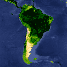
var dataset = ee.ImageCollection('MODIS/006/MOD16A2')\n .filter(ee.Filter.date('2018-01-01', '2018-05-01'));\nvar evapotranspiration = dataset.select('ET');\nvar evapotranspirationVis = {\n min: 0,\n max: 300,\n palette: [\n 'ffffff', 'fcd163', '99b718', '66a000', '3e8601', '207401', '056201',\n '004c00', '011301'\n ],\n};\nMap.setCenter(6.746, 46.529, 2);\nMap.addLayer(evapotranspiration, evapotranspirationVis, 'Evapotranspiration');\n```\n[Open in Code Editor](https://code.earthengine.google.com/?scriptPath=Examples:Datasets/MODIS/MODIS_006_MOD16A2) \n[MOD16A2.006: Terra Net Evapotranspiration 8-Day Global 500m \\[deprecated\\]](/earth-engine/datasets/catalog/MODIS_006_MOD16A2) \nThe MOD16A2 Version 6 Evapotranspiration/Latent Heat Flux product is an 8-day composite product produced at 500 meter pixel resolution. The algorithm used for the MOD16 data product collection is based on the logic of the Penman-Monteith equation, which includes inputs of daily meteorological reanalysis data along with MODIS remotely sensed ... \nMODIS/006/MOD16A2, 8-day,evapotranspiration,global,mod16a2,modis,nasa,water-vapor \n2001-01-01T00:00:00Z/2023-02-02T00:00:00Z \n-90 -180 90 180 \nGoogle Earth Engine \nhttps://developers.google.com/earth-engine/datasets\n\n- [https://doi.org/10.5067/MODIS/MOD16A2.006](https://doi.org/https://doi.org/10.5067/MODIS/MOD16A2.006)\n- [https://doi.org/10.5067/MODIS/MOD16A2.006](https://doi.org/https://developers.google.com/earth-engine/datasets/catalog/MODIS_006_MOD16A2)"]]