Page Summary
-
This dataset, MOD10A1 V6, contains daily global 500m snow cover, snow albedo, fractional snow cover, and quality assessment data.
-
The snow cover data is derived using a snow mapping algorithm based on the Normalized Difference Snow Index (NDSI).
-
This dataset has been superseded by MODIS/061/MOD10A1 and is considered deprecated.
-
The dataset is available from February 24, 2000, to February 17, 2023, with a daily cadence.
- Dataset Availability
- 2000-02-24T00:00:00Z–2023-02-17T00:00:00Z
- Dataset Producer
- NASA NSIDC DAAC at CIRES
- Cadence
- 1 Day
- Tags
Description
The MOD10A1 V6 Snow Cover Daily Global 500m product contains snow cover, snow albedo, fractional snow cover, and quality assessment (QA) data. Snow cover data are based on a snow mapping algorithm that employs a Normalized Difference Snow Index (NDSI) and other criteria tests.
Bands
Bands
Pixel size: 500 meters (all bands)
| Name | Min | Max | Scale | Pixel Size | Description | ||||||||||||||||||||||||||||||||||||||||||||||||||||||||||||||||||||||||||||||||||||||||||||||
|---|---|---|---|---|---|---|---|---|---|---|---|---|---|---|---|---|---|---|---|---|---|---|---|---|---|---|---|---|---|---|---|---|---|---|---|---|---|---|---|---|---|---|---|---|---|---|---|---|---|---|---|---|---|---|---|---|---|---|---|---|---|---|---|---|---|---|---|---|---|---|---|---|---|---|---|---|---|---|---|---|---|---|---|---|---|---|---|---|---|---|---|---|---|---|---|---|---|---|---|
NDSI_Snow_Cover |
0 | 100 | 500 meters | NDSI snow cover. This value is computed for MOD10_L2 and retrieved when the observation of the day is selected. Provider values above 100 are masked out in this band (they can be found in the "NDSI_Snow_Cover_Class" band). |
|||||||||||||||||||||||||||||||||||||||||||||||||||||||||||||||||||||||||||||||||||||||||||||||
NDSI_Snow_Cover_Basic_QA |
500 meters | A basic estimate of the quality of the algorithm result. This value is computed for MOD10_L2 and retrieved with the corresponding observation of the day. |
|||||||||||||||||||||||||||||||||||||||||||||||||||||||||||||||||||||||||||||||||||||||||||||||||
NDSI_Snow_Cover_Algorithm_Flags_QA |
500 meters | Bit flags indicating screen results and the presence of inland water. These flags are set when MOD10_L2 is generated and retrieved with the corresponding observation of the day. |
|||||||||||||||||||||||||||||||||||||||||||||||||||||||||||||||||||||||||||||||||||||||||||||||||
NDSI |
0 | 10000 | 0.0001 | 500 meters | Raw NDSI (i.e. prior to screening). This value is computed for MOD10_L2 and retrieved with the corresponding observation of the day. |
||||||||||||||||||||||||||||||||||||||||||||||||||||||||||||||||||||||||||||||||||||||||||||||
Snow_Albedo_Daily_Tile |
1 | 100 | 500 meters | Snow albedo percentage. Provider values above 100 are masked out in this band (they can be found in the "Snow_Albedo_Daily_Tile_Class" band). |
|||||||||||||||||||||||||||||||||||||||||||||||||||||||||||||||||||||||||||||||||||||||||||||||
orbit_pnt |
500 meters | Pointer to the orbit number of the swath that was selected as the observation of the day. The pointer references by index the list of orbit numbers written to the ORBITNUMBERARRAY metadata object in ArchiveMetadata.0. |
|||||||||||||||||||||||||||||||||||||||||||||||||||||||||||||||||||||||||||||||||||||||||||||||||
granule_pnt |
500 meters | Pointer to the granule (swath) that was mapped into the tile. The pointer references the corresponding value in the GRANULEPOINTERARRAY metadata object written to ArchiveMetadata.0. |
|||||||||||||||||||||||||||||||||||||||||||||||||||||||||||||||||||||||||||||||||||||||||||||||||
NDSI_Snow_Cover_Class |
500 meters | Landcover classes from the "NDSI_Snow_Cover" subdataset (provider values less than or equal to 100 are masked out). |
|||||||||||||||||||||||||||||||||||||||||||||||||||||||||||||||||||||||||||||||||||||||||||||||||
Snow_Albedo_Daily_Tile_Class |
500 meters | Landcover classes from the "Snow_Albedo_Daily_Tile" subdataset (provider values less than or equal to 100 are masked out). |
|||||||||||||||||||||||||||||||||||||||||||||||||||||||||||||||||||||||||||||||||||||||||||||||||
NDSI_Snow_Cover_Class Class Table
| Value | Color | Description |
|---|---|---|
| 200 | None | Missing data |
| 201 | None | No decision |
| 211 | None | Night |
| 237 | None | Inland water |
| 239 | None | Ocean |
| 250 | None | Cloud |
| 254 | None | Detector saturated |
Snow_Albedo_Daily_Tile_Class Class Table
| Value | Color | Description |
|---|---|---|
| 101 | None | No decision |
| 111 | None | Night |
| 125 | None | Land |
| 137 | None | Inland water |
| 139 | None | Ocean |
| 150 | None | Cloud |
| 151 | None | Cloud detected as snow |
| 250 | None | Missing |
| 251 | None | Self-shadowing |
| 252 | None | Land mask mismatch |
| 253 | None | BRDF failure |
| 254 | None | Non-production mask |
Terms of Use
Terms of Use
You may download and use photographs, imagery, or text from the NSIDC web site, unless limitations for its use are specifically stated. For more information on usage and citing NSIDC datasets, please visit the NSIDC 'Use and Copyright' page.
Citations
Hall, D. K., V. V. Salomonson, and G. A. Riggs. 2016. MODIS/Terra Snow Cover Daily L3 Global 500m Grid. Version 6. Boulder, Colorado USA: NASA National Snow and Ice Data Center Distributed Active Archive Center.
DOIs
Explore with Earth Engine
Code Editor (JavaScript)
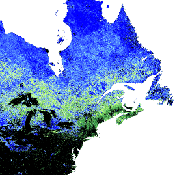
var dataset = ee.ImageCollection('MODIS/006/MOD10A1')
                  .filter(ee.Filter.date('2018-01-01', '2018-05-01'));
var snowCover = dataset.select('NDSI_Snow_Cover');
var snowCoverVis = {
  min: 0.0,
  max: 100.0,
  palette: ['black', '0dffff', '0524ff', 'ffffff'],
};
Map.setCenter(-41.13, 76.35, 2);
Map.addLayer(snowCover, snowCoverVis, 'Snow Cover');