Page Summary
-
This dataset contains monthly global gridded 500m burned area and quality information.
-
The data is available from 2000-11-01 to 2022-12-01 and was provided by NASA LP DAAC at the USGS EROS Center.
-
The dataset has bands including BurnDate, Uncertainty, QA, FirstDay, and LastDay, each with a pixel size of 500 meters.
-
Usage of this data is unrestricted for subsequent use, sale, or redistribution.
- Dataset Availability
- 2000-11-01T00:00:00Z–2022-12-01T00:00:00Z
- Dataset Producer
- NASA LP DAAC at the USGS EROS Center
- Cadence
- 1 Month
- Tags
Description
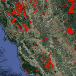
The Terra and Aqua combined MCD64A1 Version 6 Burned Area data product is a monthly, global gridded 500m product containing per-pixel burned-area and quality information. The MCD64A1 burned-area mapping approach employs 500m MODIS Surface Reflectance imagery coupled with 1km MODIS active fire observations. The algorithm uses a burn sensitive vegetation index (VI) to create dynamic thresholds that are applied to the composite data. The VI is derived from MODIS shortwave infrared atmospherically corrected surface reflectance bands 5 and 7 with a measure of temporal texture. The algorithm identifies the date of burn for the 500m grid cells within each individual MODIS tile. The date is encoded in a single data layer as the ordinal day of the calendar year on which the burn occurred, with values assigned to unburned land pixels and additional special values reserved for missing data and water grid cells.
Documentation:
Bands
Bands
Pixel size: 500 meters (all bands)
| Name | Min | Max | Pixel Size | Description | |||||||||||||||||||||||||||||||||||||||||||||||||||||||||||||||||||||||||||||||||||||||||||||||
|---|---|---|---|---|---|---|---|---|---|---|---|---|---|---|---|---|---|---|---|---|---|---|---|---|---|---|---|---|---|---|---|---|---|---|---|---|---|---|---|---|---|---|---|---|---|---|---|---|---|---|---|---|---|---|---|---|---|---|---|---|---|---|---|---|---|---|---|---|---|---|---|---|---|---|---|---|---|---|---|---|---|---|---|---|---|---|---|---|---|---|---|---|---|---|---|---|---|---|---|
BurnDate |
0 | 366 | 500 meters | Burn day of year. Possible values: 0 (unburned), 1-366 (approximate Julian day of burning). |
|||||||||||||||||||||||||||||||||||||||||||||||||||||||||||||||||||||||||||||||||||||||||||||||
Uncertainty |
0 | 100 | 500 meters | Estimated uncertainty in burn day |
|||||||||||||||||||||||||||||||||||||||||||||||||||||||||||||||||||||||||||||||||||||||||||||||
QA |
500 meters | Quality assurance indicators |
|||||||||||||||||||||||||||||||||||||||||||||||||||||||||||||||||||||||||||||||||||||||||||||||||
FirstDay |
0 | 366 | 500 meters | First day of the year of reliable change detection |
|||||||||||||||||||||||||||||||||||||||||||||||||||||||||||||||||||||||||||||||||||||||||||||||
LastDay |
0 | 366 | 500 meters | Last day of the year of reliable change detection |
|||||||||||||||||||||||||||||||||||||||||||||||||||||||||||||||||||||||||||||||||||||||||||||||
Terms of Use
Terms of Use
MODIS data and products acquired through the LP DAAC have no restrictions on subsequent use, sale, or redistribution.
Citations
Please visit LP DAAC 'Citing Our Data' page for information on citing LP DAAC datasets.
DOIs
Explore with Earth Engine
Code Editor (JavaScript)
var dataset = ee.ImageCollection('MODIS/006/MCD64A1')
                  .filter(ee.Filter.date('2017-01-01', '2018-05-01'));
var burnedArea = dataset.select('BurnDate');
var burnedAreaVis = {
  min: 30,
  max: 341,
  palette: ['4e0400', '951003', 'c61503', 'ff1901'],
};
Map.setCenter(6.746, 46.529, 2);
Map.addLayer(burnedArea, burnedAreaVis, 'Burned Area');
import ee
import geemap.core as geemap
Colab (Python)
dataset = ee.ImageCollection('MODIS/006/MCD64A1').filter(
    ee.Filter.date('2017-01-01', '2018-05-01')
)

burned_area = dataset.select('BurnDate')

burned_area_vis = {
    'min': 30,
    'max': 341,
    'palette': ['4e0400', '951003', 'c61503', 'ff1901'],
}

m = geemap.Map()
m.set_center(6.746, 46.529, 2)
m.add_layer(burned_area, burned_area_vis, 'Burned Area')
m